Cascade Creek


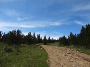
Some of us wanted to get another snow run in and Cascade Creek seemed a good choice. It's close to Denver in case any breakages occur, and it's a relatively easy trail with little danger of damage or mishaps if you get bogged down in the snow.
We met at the McDonalds in Idaho Springs and aired down there. After everyone had arrived, aired down and disconnected we departed for the trailhead. We headed down the road toward Mt. Evans out of Idaho Springs. Soon after the turn-off for Ute Creek, the Cascade Creek turn-off appeared, and we turned right and immediately headed up the trail. The snow wasn't too deep early in the trail, and we wondered if we were going to have a mild day in the snow after all.
It wasn't long before we reached the old abandoned Molly Bawn mine. We stopped briefly to take a couple photos of the gated mine entrance and some old equipment, and resumed our journey.
Not far past the mine, we ran into the first bit of deep snow. Eric, in the lead, was now breaking through fresh snow over a foot deep. He had to work a little to get through a small drift after a switchback. Bob followed, also getting a bit bogged down, and had to use a little more speed to break through the snow. The remainder of the group followed through with less trouble.
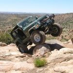
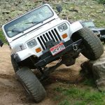
A little further on, we came to the base of the main feature of this trail, a somewhat steep hill with some rocks placed here and there. This hill is normally a nice little climb, but one that usually poses little difficulty even for a stock 4x4 vehicle. Today was a different story, though, because the hill was covered in anywhere from one to three feet of snow.
Eric hit the hill first. He took a few runs at the first hill section before he made it. He stopped at one point, his tires having made dips in the snow as large as they were, and his jeep just sat there oscillating with the wheels turning, but going nowhere. He backed out of the holes, tried a different line to the right, and made his way up the hill.
Bob followed up the hill, and, after Eric had broken tracks in the snow, was able to follow up the hill with no issues. At a switchback on the hill, though, Eric popped right over some rocks at the top of the turn, but Bob didn't have as much luck. He slipped off the line, falling back to the right. He managed to back down and re-set his line, and this time, with some more speed, managed to make it up the hill.
Don came soon after, up the hill with no trouble, making it look easy. As Gary started making his way up the hill, Eric continued to the second half (the bigger half) of the hill, and started working on it. Bob followed, to see if he could assist.
While Eric and Bob were working on the second half of the hill, JJ came up the first half of the hill and had no troubles, walking right up the hill. Austin came up the hill right behind him. On the switchback turn, Austin slipped into the same area Bob had. He re-aligned further to the left, though, and walked right up the remaining rocks with his new 36" tires. After Austin, Mike made his way up the first half of the hill, making short work of it, and quickly joining everyone waiting to tackle the second half of the hill.
The second half of the hill proved to be too deep for any of us. While the second half of the group was making their way up the first half of the hill, Eric had gotten only about a quarter of the way up the second half of the hill, and ended up having to winch from there. It took three seperate winch pulls to get him to the top of the hill, where he was able to turn right and start heading down to the next part of the trail.
Bob gunned the engine and tried to get further now that Eric had plowed tracks into the snow, but first, second, and even third gear couldn't get him any further. He also broke out the winch line and tackled the long task of winching his way up and over the hill.
Don came next, and again, valiant effort aside, was unable to make it further than Eric had originally gone. Out came his winch rope, and up the hill he crawled.
Gary gave a heck of a go at the hill, but had to winch as well. After his first winch pull, though, he was able to push forward a bit further in the snow before reconnecting his winch for the second pull, then proceeded via winch power the rest of the way over the hill.
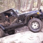
After Gary, JJ headed up the hill. He had a bright and shiny yellow synthetic winch line that got some good exercise, as it ended up pulling him all the way up the hill from the same point as the rest of us.
Only Austin and Mike now remained. The winching operation was taking a while and we were all getting tired. Plus, it was well after noon, and some of us were getting hungry. However, we wanted to finish winching everyone up and over the hill, so we pushed on.
Austin headed up the hill, and made some good strides, but still had to winch up all three pulls as the rest of us had. He had to push a little more between winchings, though, because his rope was only 80 feet in length. After the first pull, he gunned it up the snowy rocks before attaching to the second winch point, and for a moment, we all thought he was going to make it without winching. The rock proved to slippery, though, and he had to winch after all.
Finally, it was Mike's turn to head up this final portion of this snowy hill. He attacked it as everyone else, but ended up winching up to the first point. He then tried to drive to the second point as Austin had, but ran into a bit of a snag. As he was spinning his tires in the snow, his rig turned sideways, with his rear end coming up to his right. At this point, to be safe, he connected his winch line to the second winch point, and pulled his front back around to face up the mountain, and winched himself the remainder of the way up the mountain.
After all that work winching, we headed down the trail to find a sunnier spot for lunch. Not a minute had passed, though, and we found ourselves about to cross a somewhat deep drift that was going down across the trail, causing a lateral slope to appear in front of us.
Eric started across it, but his rear end started slipping down to the right, getting close to the edge of the trail. We ended up connecting his winch to a tree further down the trail to straighten his front out, and after a couple of short winch pulls, he was through. In the meantime, Mike busied himself digging at the snow on the uphill side of the drift to aid the rest of us in getting across. The rest of us followed Eric through the drift, and managed to make it through with minimal sliding.
We were nearing the end of the trail, and thought we were home free. Eric headed down a final sloping hill, but was surprised by an unexpectedly deep drift that swallowed him up to his bumpers. At this point, we decided to go ahead and have lunch, as some of us were getting pretty hungry. It was very cold (20 degrees), though, with a slight breeze, so we all elected to eat our lunches in our Jeeps.
After we finished lunch, Eric hooked his winch up to a tree strap around a massive old tree that was almost six feet around, and pulled himself through the drift and onto the Ute Creek road, which had only been a stone's throw from where he'd gotten stuck in the snow. Bob followed, using a good amount of momentum to ensure he wouldn't get stuck as well, and practically hydroplaned over the top of the snow to get through. Don followed without issue, along with Gary, JJ, Austin, and Mike.
We all headed down the Ute Creek trail back to the road, and cruised back to Idaho Springs, where we aired up at a gas station. It was still rather early (3:00 PM), so after we finished airing up and reconnecting everyone said their goodbyes and headed home. It had been a good day in the snow.


Reports from Other Days: 4
Use the arrows or dots to flip through the previews of the other reports for Cascade Creek. Click one of them to read more and see all of the photos from that day.