TrailDamage.com

Photos, videos and information about 4x4 trails in Colorado and Utah

  • Trails
    • Colorado
    • Utah
  • Reports
    • Featured Photos
    • Featured Videos
    • Reports Calendar
  • Members
  • Search
  • Trail Damage Winners
  • FAQ
  • Community
  • Upcoming Events
  • Membership
  • Log In
  • Facebook
  • Instagram
  • RSS
  • Twitter
  • YouTube

Swan River 140726

July 26, 2014 by Monica

Swan River

Trail Run on July 26, 2014
Report and photos by Monica I., Trail Leader
View trail information for Swan River

Paula S.
Silver 2000 Jeep Wrangler
Austin C.
Khaki 2004 Jeep Wrangler Unlimited Rubicon
Matt K.
White 2016 Jeep Wrangler Unlimited Rubicon
Gary R.
Yellow 1978 Jeep CJ-7
Julie M.
Green 2012 Jeep Wrangler Unlimited Rubicon
Monica I.
Red 2010 Jeep Wrangler Rubicon
Walt S.
Gray 2022 Jeep Wrangler Unlimited Rubicon 392

We came off of Georgia Pass and it was lightly raining as we headed up the Middle Fork of the Swan River trail. There were a few people camping near the start, and we wondered how the mosquitoes were treating them. It wasn't long before the trail started climbing up the steep hill.

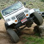
There were a couple trucks ahead of us, but they were making good time. There was a new rock in the trail that made one section a bit challenging. Stock-height vehicles had to go around it, putting them close to the edge. The trucks did fine, with good spotting and driving.

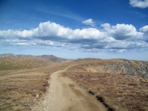
A lot of the climb was in a trench, which made it very safe though very steep, still. It was a fun climb.

When we got to timberline at the switchback with the mine tailings, the trucks pulled to the side and we went by them. We cut up the hill and then headed to Wise Mountain. We had lunch there by the cabin, and the scenery was gorgeous. It rained a little bit off and on, but nothing serious. There was a bit of traffic on the trail.

There were mountain goats all over, and they got pretty close to the cabin and where we were. They were all getting rid of their winter coats, and there were some young ones in the small group. They were definitely used to having people and vehicles around them, but they didn't approach us for food. That was a good sign.

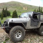
After some exploring and wrapping up lunch we headed up to the ridge. There are a few options up the steep hill, and everyone picked their own path. No one had much trouble, though the hill was loose and rocky. It was a great climb to the top.

We went across the ridge, enjoying driving at the top of the world. We passed by Saints John and took the Deer Creek trail down to Montezuma. Then we took Saints John back up to finish Swan River. There were people from the forest service out on dirt bikes and we would see them off and on along the trail.

We went down the Middle Fork of the Swan River trail and it was much looser and rockier than it was when we were there last. We would definitely need to change our usual way around the loop so we did the Middle Fork uphill instead of downhill. It was fun and very scenic. We stopped for a break at timberline and there were flowers everywhere.

We stopped in Swandyke, but only briefly. We had S.O.B. Hill on our minds. We took that trail to the rock garden, and it was raining hard. The rocks were muddy and the garden was very torn up. It would have been fun if it was dry, but it wasn't and it was pretty impossible. Rather than dragging winch lines out we decided to save it for another day. Bummer!

Swan River is such a great trail, and we had a fantastic day. Airing up in the hail and hard rain is always a challenge, but after a great day it isn't too bad. We had dinner in Dillon before heading down to Denver, wrapping up a near-perfect day.

alpine
basin
bobsled_run
bumpy
chunky
climbing_the_ridge_from_wise_mountain
curve
deer_creek_sign
down_the_middle_fork
dug_in
first_climb
forest_service_sign
fun_descent
gary_walt_and_austin
jeeps_in_scenery
julie_up_the_ridge
laurie_on_wise_mountain
laurie
layers
loose
lush
matt_in_scenery
middle_fork_part_1
middle_fork_part_2
middle_fork_part_3
middle_fork_part_4
middle_fork_part_5
mine_tailings
mining_remnant
mist
monica_and_matt
mountain_goats_at_the_wise_mountain_cabin
mountain_goats_part_1
mountain_goats_part_2
mountain_goats_part_3
mountain_goats_part_4
north_fork_part_1
north_fork_part_2
north_fork_part_3
old_cabin
parked_near_the_middle_fork
parked_on_wise_mountain
paula_muddy
paula_on_the_trail
paula_parked_part_1
paula_parked_part_2
paula_parked_part_3
ridge_climb
ridge_view_part_1
ridge_view_part_2
ridge_view_part_3
ridge_view_part_4
ridge_view_part_5
ridge_view_part_6
river_crossing
rocky_climb
scenery
sheep_mountain
snow
storm_clouds
straight_climb
swandyke_cabin_part_1
swandyke_cabin_part_2
swandyke_car
tall_trees
timberline
to_montezuma
trail_above_timberline
trail_ahead
trail_with_a_view
trench
trouble
up_the_ridge
valley_view
view_from_wise_mountain_part_1
view_from_wise_mountain_part_2
view_from_wise_mountain_part_3
view_from_wise_mountain_part_4
view_from_wise_mountain_part_5
view_from_wise_mountain_part_6
view_from_wise_mountain_part_7
wet_trail
wise_mountain_cabin_part_1
wise_mountain_cabin_part_2
wise_mountain_cabin_part_3
wise_mountain_cabin_part_4
wise_mountain_cabin_part_5
wise_mountain_cabin_part_6

Reports from Other Days: 3

Use the arrows or dots to flip through the previews of the other reports for Swan River. Click one of them to read more and see all of the photos from that day.

September 24, 2011

Led by Monica I.
Our group split up after doing the Saints John trail. Five of us continued on to do Swan River. We ran it in the clockwise direction, going down the middle fork so we could go up the steep north fork. We left the end of the Deer Creek trail and…
»
  • 1
  • 2
  • 3
Join Us!
If you aren’t a Member or Subscriber, you can’t see all of the content on this site. Get membership information to see why this site is best when you join and log in

Information for Subscribers

When you log in you’ll see more information here:

  • Recent Community Forum posts
  • Recent polls
  • Upcoming Events you can attend
  • Links to online users

© 2000-2023 · TrailDamage.com · Terms and Conditions · About · Contact
Trail information is only accurate on the date posted. Trails may have changed or closed since that date. Use this information for historical purposes only.
Contact the Forest Service or Bureau of Land Management for up-to-date trail information.

/* ----------------------------------------- */ /* View slug: reports-other-reports-for-same-trail-slider - start */ /* ----------------------------------------- */ /* place the prev/next controls on the sides */ .td-transition-controls .wpv-filter-next-link, .td-transition-controls .wpv-filter-previous-link { border: none; font-size: 300%; position: absolute; top: 70px; } .td-transition-controls .wpv-filter-previous-link { left: 0; } .td-transition-controls .wpv-filter-next-link { right: 0; } /* center the page selector horizonatally */ .td-transition-controls ul.wpv_pagination_dots { text-align: center; margin-top: 10px; } /* center the page selector horizonatally */ .td-transition-controls ul.wpv_pagination_dots li.wpv_pagination_dots_item, .td-transition-controls .wpv_pagination_dots li a { display: inline-block; float: none; } /* remove the default styles */ .td-transition-controls .wpv_pagination_dots li a { text-decoration: none; border-bottom: none; } .td-slider-container { padding: 0 25px; margin-bottom: 20px; position: relative; width:100%; display:table; } .td-slides { position: relative; } .td-slides-image { float:left; display:table-cell; } .td-slides-image img { border:1px solid #c0c0c0; } .td-slides-content { padding:4px 4px 4px 10px; border-top:1px solid #c0c0c0; border-right:1px solid #c0c0c0; border-bottom:1px solid #c0c0c0; display:table-cell; height:227px; overflow:hidden; } .td-slides-content h3 { margin-top:8px; } .td-slides-leader { font-size:smaller; margin-top:4px; } /* ----------------------------------------- */ /* View slug: reports-other-reports-for-same-trail-slider - end */ /* ----------------------------------------- */
/* ----------------------------------------- */ /* Content Template: Template for a Single Report - start */ /* ----------------------------------------- */ .entry-header { display:none; } .entry-content h1 { margin-top:16px; padding-top:0; } h1 a { color:#222; } h1 a:hover { color:#666; } p.entry-meta { font-size:small; } #report-body-spacer { clear:both; width:100%; height:20px; } #addtoany-bar { margin-bottom:2em; text-align:center; } .category-reports .post-info .author, .post-info .date { display: none; } .addthis_recommended_horizontal { text-align:center !important; } /* ----------------------------------------- */ /* Content Template: Template for a Single Report - end */ /* ----------------------------------------- */ /* ----------------------------------------- */ /* Content Template: Loop item in REPORTS Runners - start */ /* ----------------------------------------- */ #runners-container { width:100%; clear:both; } .runner { border:1px solid #c0c0c0; margin:0 6px 6px 0; float:left; width:49%; height:81px; } .runner-image { float: left; } .runner-image img { margin:2px 10px 0 2px; height:75px; width:75px; } .runner-name { text-transform:uppercase; } .runner-name a { color:#222; } .runner-name a:hover { color:#666; } .runner-vehicle { font-size:small; } @media only screen and (max-width: 768px) { .runner { width:100%; } } /* ----------------------------------------- */ /* Content Template: Loop item in REPORTS Runners - end */ /* ----------------------------------------- */