TrailDamage.com

Photos, videos and information about 4x4 trails in Colorado and Utah

  • Trails
    • Colorado
    • Utah
  • Reports
    • Featured Photos
    • Featured Videos
    • Reports Calendar
  • Members
  • Search
  • Trail Damage Winners
  • FAQ
  • Community
  • Upcoming Events
  • Membership
  • Log In
  • Facebook
  • Instagram
  • RSS
  • Twitter
  • YouTube

Swan River 110924

September 24, 2011 by Monica

Swan River

Trail Run on September 24, 2011
Report and photos by Monica I., Trail Leader
View trail information for Swan River

Bill S.
Yellow 2020 Jeep Wrangler Rubicon
Walt S.
Gray 2022 Jeep Wrangler Unlimited Rubicon 392
Hoa Q.
Black 1995 Land Rover Range Rover
Monica I.
Red 2010 Jeep Wrangler Rubicon
Mike S.
Silver 2004 Jeep Wrangler Rubicon

Our group split up after doing the Saints John trail. Five of us continued on to do Swan River. We ran it in the clockwise direction, going down the middle fork so we could go up the steep north fork.

We left the end of the Deer Creek trail and it was a pretty quick trip to the town of Swandyke. We got out here to stretch our legs and take some pictures. We really wish we knew more about the upside-down car! It's so weird.

We left Swandyke just as another Jeep arrived so we went on ahead and didn't see them again. We were a bit sad to pass the trailhead for S.O.B. Hill as we had hoped to get to it while we were there. We just didn't have enough time. We'll save it for another day because it's one of our favorites.

There were a few people camping near the bottom at Tiger Road but it wasn't that busy. We ended up behind a car for the last bit of the trail so it was slow going. Still, it wasn't long before we were heading up the north fork.

This side of the trail is definitely more interesting. It's a long and narrow trench as you work your way up the steep hill in Garibaldi Gulch. There were even some bigger rocks to play on.

We were almost out of the trench and out of the trees at the mine where we leave the trees behind when we saw a big truck on its way down. We had nowhere to go so the truck worked on getting out of the way. It didn't look like he had lockers and that section of trail was loose and uneven, giving him some troubles. He worked really hard at it, though, and was soon off of the trail. He was grinning when we went by so he enjoyed himself.

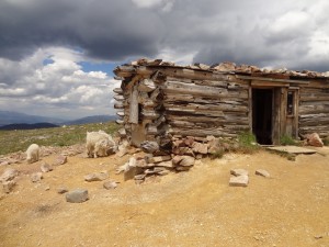
When we got to the spur to go up to Wise Mountain we took it and parked at the cabin. There wasn't anyone in the cabin but we saw a cooler behind it. We looked around a little and took some pictures but we didn't stay long.

It was getting chilly as the sun threatened to leave us for the day. We still had the crazy hill climb and we all had a great time. Well, Hoa might not have enjoyed it as much as the rest of us because he really had to work on it. He had just bought new tires, though, so the work paid off and he made it up the hill without any assistance.

Just after the hill we could see some people wandering around with some goats. It took us a while to get there but when we got there it looked like they had been feeding them. We didn't want to add any more damage so we slowly worked our way through the people and goats. We couldn't believe that people would just get out and feed wild animals.

But then we were passed by a couple of dirt bikes who just tore through the area off of the trail even though we stopped to let them by with enough room next to us on the trail. We were really seeing some bad examples.

But the scenery continued to be gorgeous and we forgot about the bad examples until a few minutes later when we came up to some people letting their dogs run loose everywhere. We were just about ready to get off of the trail at that point. It's frustrating to see people not using any common sense.

Even with all of that we still really enjoyed our loop around Swan River. We passed by the Saints John trail and soon headed down Deer Creek to end our day. We were glad we took the time to do the extra loop.

above_timberline
above_wise_mountain
beaver_ponds
between_saints_john_and_deer_creek
big_view
bill_and_walt
bill_at_swandyke
bill_up_the_hill
bottom_of_the_north_fork
cabin_with_a_view
clear_water
clouds
colorado_scenery
crack
creek_crossing
creek
curves
different_colors
fall_colors
footbridge
gorgeous
hoa_at_swandyke
into_the_trees
layers
marsh
middle_fork_near_the_top
mike_at_swandyke
mike_on_the_trail
monica_at_swandyke
mountain_of_rocks
north_fork_hill_climb
north_fork
open_space
parked_at_wise_mountain
reds
sheep_mountain_basin
sheep_mountain
sheep_part_1
sheep_part_2
sheep_part_3
sheep_part_4
snowfield
swan_river
swandyke_cabin_part_1
swandyke_cabin_part_2
trail_sign
up_the_north_fork_part_1
up_the_north_fork_part_2
up_the_north_fork_part_3
up_the_north_fork_part_4
up_the_north_fork_part_5
upside_down_car_part_1
upside_down_car_part_2
view_from_wise_mountain_part_1
view_from_wise_mountain_part_2
walt_at_swandyke
wise_mountain_in_the_distance
wise_mountain_part_1
wise_mountain_part_2
wise_mountain_part_3
wise_mountain_part_4
wise_mountain_part_5

Reports from Other Days: 3

Use the arrows or dots to flip through the previews of the other reports for Swan River. Click one of them to read more and see all of the photos from that day.

July 26, 2014

Led by Monica I.
We came off of Georgia Pass and it was lightly raining as we headed up the Middle Fork of the Swan River trail. There were a few people camping near the start, and we wondered how the mosquitoes were treating them. It wasn’t long before the trail started climbing up…
»
  • 1
  • 2
  • 3
Join Us!
If you aren’t a Member or Subscriber, you can’t see all of the content on this site. Get membership information to see why this site is best when you join and log in

Information for Subscribers

When you log in you’ll see more information here:

  • Recent Community Forum posts
  • Recent polls
  • Upcoming Events you can attend
  • Links to online users

© 2000-2022 · TrailDamage.com · Terms and Conditions · About · Contact
Trail information is only accurate on the date posted. Trails may have changed or closed since that date. Use this information for historical purposes only.
Contact the Forest Service or Bureau of Land Management for up-to-date trail information.

/* ----------------------------------------- */ /* View slug: reports-other-reports-for-same-trail-slider - start */ /* ----------------------------------------- */ /* place the prev/next controls on the sides */ .td-transition-controls .wpv-filter-next-link, .td-transition-controls .wpv-filter-previous-link { border: none; font-size: 300%; position: absolute; top: 70px; } .td-transition-controls .wpv-filter-previous-link { left: 0; } .td-transition-controls .wpv-filter-next-link { right: 0; } /* center the page selector horizonatally */ .td-transition-controls ul.wpv_pagination_dots { text-align: center; margin-top: 10px; } /* center the page selector horizonatally */ .td-transition-controls ul.wpv_pagination_dots li.wpv_pagination_dots_item, .td-transition-controls .wpv_pagination_dots li a { display: inline-block; float: none; } /* remove the default styles */ .td-transition-controls .wpv_pagination_dots li a { text-decoration: none; border-bottom: none; } .td-slider-container { padding: 0 25px; margin-bottom: 20px; position: relative; width:100%; display:table; } .td-slides { position: relative; } .td-slides-image { float:left; display:table-cell; } .td-slides-image img { border:1px solid #c0c0c0; } .td-slides-content { padding:4px 4px 4px 10px; border-top:1px solid #c0c0c0; border-right:1px solid #c0c0c0; border-bottom:1px solid #c0c0c0; display:table-cell; height:227px; overflow:hidden; } .td-slides-content h3 { margin-top:8px; } .td-slides-leader { font-size:smaller; margin-top:4px; } /* ----------------------------------------- */ /* View slug: reports-other-reports-for-same-trail-slider - end */ /* ----------------------------------------- */
/* ----------------------------------------- */ /* Content Template: Template for a Single Report - start */ /* ----------------------------------------- */ .entry-header { display:none; } .entry-content h1 { margin-top:16px; padding-top:0; } h1 a { color:#222; } h1 a:hover { color:#666; } p.entry-meta { font-size:small; } #report-body-spacer { clear:both; width:100%; height:20px; } #addtoany-bar { margin-bottom:2em; text-align:center; } .category-reports .post-info .author, .post-info .date { display: none; } .addthis_recommended_horizontal { text-align:center !important; } /* ----------------------------------------- */ /* Content Template: Template for a Single Report - end */ /* ----------------------------------------- */ /* ----------------------------------------- */ /* Content Template: Loop item in REPORTS Runners - start */ /* ----------------------------------------- */ #runners-container { width:100%; clear:both; } .runner { border:1px solid #c0c0c0; margin:0 6px 6px 0; float:left; width:49%; height:81px; } .runner-image { float: left; } .runner-image img { margin:2px 10px 0 2px; height:75px; width:75px; } .runner-name { text-transform:uppercase; } .runner-name a { color:#222; } .runner-name a:hover { color:#666; } .runner-vehicle { font-size:small; } @media only screen and (max-width: 768px) { .runner { width:100%; } } /* ----------------------------------------- */ /* Content Template: Loop item in REPORTS Runners - end */ /* ----------------------------------------- */