TrailDamage.com

Photos, videos and information about 4x4 trails in Colorado and Utah

  • Trails
    • Colorado
    • Utah
  • Reports
    • Featured Photos
    • Featured Videos
    • Reports Calendar
  • Members
  • Search
  • Trail Damage Winners
  • FAQ
  • Community
  • Upcoming Events
  • Membership
  • Log In
  • Facebook
  • Instagram
  • RSS
  • Twitter
  • YouTube

Rampart Range Road 060826

August 26, 2006 by Monica

Rampart Range Road

Trail Run on August 26, 2006
Report and photos by Monica I., Trail Leader
View trail information for Rampart Range Road

Dave E.
Blue 1999 Jeep Cherokee
Roger R.
Gray 2021 Jeep Wrangler Rubicon 4xe
Mike S.
Silver 2004 Jeep Wrangler Rubicon
Monica I.
Red 2010 Jeep Wrangler Rubicon
Matt F.
Silver 2000 Jeep Wrangler
Gary R.
Yellow 1978 Jeep CJ-7
Ladd G.
Green 2003 Jeep Wrangler Rubicon
Cheryl W.
Orange 2006 Jeep Wrangler Unlimited Rubicon
Walt S.
Gray 2022 Jeep Wrangler Unlimited Rubicon 392
Julie M.
Green 2012 Jeep Wrangler Unlimited Rubicon

We saw bits and pieces of Rampart Range Road throughout our day as we did a lot of the trails in the area. First we saw just a little bit of it between Dakan Road and Long Hollow Road, then we saw the majority of the south end and middle of it as we worked our way up.

Ladd left early, and he took Rampart Range Road all the way out to the north. Technically, Ladd was the only one who saw the entire trail. The rest of us saw different pieces of it as we split up throughout the day.

We came down Highway 67 from finishing Long Hollow Road and most of us gassed up in Colorado Springs before we headed up to the Garden of the Gods park. Those who gassed up would be able to finish the day, and those who didn't would have to leave early. We covered a lot of miles in one day, and a lot of us went through just a bit more than an entire tank of gas.

We started into the park and unfortunately got behind a tour bus. There was a long line of cars as the bus got to speeds of 5mph with many stops along the way. It took us awhile to get to Balanced Rock even though it's not very far into the park. Even though it was slow going we all had a chance to enjoy the scenery, which was a nice benefit.

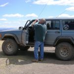
We had a hard time finding enough parking, but we worked it out. Then we all sat on some rock ledges and had a great lunch. We definitely attracted some attention -- you don't often see a large group of people having lunch together at a tourist area like that. We even took a silly picture of everyone pointing in a different direction.

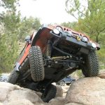
The start of Rampart Range Road at the south end was a lot different than the road to the north and in the middle. It was very rocky and bumpy for quite awhile.

There were some gorgeous houses on that end, and a shooting area fairly close by that was pretty crowded.

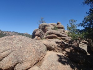
We were getting close to Schubarth Road when the trail finally mellowed out. It was bumpy, but the views were amazing.

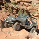
This would be a great trail to do on its own for someone in an SUV or someone who is new to wheeling.

The best part was lunch at Balanced Rock in the Garden of the Gods park. The sun was out and it was the perfect temperature when we got there.

balanced_rock
big_view
blue_sky
colorado_springs
following_a_tour_bus
julie_on_the_trail
kissing_camels_and_white_rock
kissing_camels
ladd_on_the_trail
lunch_part_1
lunch_part_2
lunch_part_3
matt_on_the_trail
mellow_road
mike_on_the_trail
rainy
roger_and_ladd
signature_rock
south_end_of_the_trail
start_of_garden_of_the_gods_road
tourists
white_rock_and_kissing_camels
white_rock_and_north_gateway_rock

Reports from Other Days: 2

Use the arrows or dots to flip through the previews of the other reports for Rampart Range Road. Click one of them to read more and see all of the photos from that day.

June 12, 2011

Led by Matt K.
It was a nice, warm, sunny day. Matt’s new axle basically blew up in Moab last month and this was his test run with the new, replacement axle. Matt started Rampart Range Road from the south end. When he got to the Garden of the Gods the road was closed…
»
  • 1
  • 2
Join Us!
If you aren’t a Member or Subscriber, you can’t see all of the content on this site. Get membership information to see why this site is best when you join and log in

Information for Subscribers

When you log in you’ll see more information here:

  • Recent Community Forum posts
  • Recent polls
  • Upcoming Events you can attend
  • Links to online users

© 2000-2023 · TrailDamage.com · Terms and Conditions · About · Contact
Trail information is only accurate on the date posted. Trails may have changed or closed since that date. Use this information for historical purposes only.
Contact the Forest Service or Bureau of Land Management for up-to-date trail information.

/* ----------------------------------------- */ /* View slug: reports-other-reports-for-same-trail-slider - start */ /* ----------------------------------------- */ /* place the prev/next controls on the sides */ .td-transition-controls .wpv-filter-next-link, .td-transition-controls .wpv-filter-previous-link { border: none; font-size: 300%; position: absolute; top: 70px; } .td-transition-controls .wpv-filter-previous-link { left: 0; } .td-transition-controls .wpv-filter-next-link { right: 0; } /* center the page selector horizonatally */ .td-transition-controls ul.wpv_pagination_dots { text-align: center; margin-top: 10px; } /* center the page selector horizonatally */ .td-transition-controls ul.wpv_pagination_dots li.wpv_pagination_dots_item, .td-transition-controls .wpv_pagination_dots li a { display: inline-block; float: none; } /* remove the default styles */ .td-transition-controls .wpv_pagination_dots li a { text-decoration: none; border-bottom: none; } .td-slider-container { padding: 0 25px; margin-bottom: 20px; position: relative; width:100%; display:table; } .td-slides { position: relative; } .td-slides-image { float:left; display:table-cell; } .td-slides-image img { border:1px solid #c0c0c0; } .td-slides-content { padding:4px 4px 4px 10px; border-top:1px solid #c0c0c0; border-right:1px solid #c0c0c0; border-bottom:1px solid #c0c0c0; display:table-cell; height:227px; overflow:hidden; } .td-slides-content h3 { margin-top:8px; } .td-slides-leader { font-size:smaller; margin-top:4px; } /* ----------------------------------------- */ /* View slug: reports-other-reports-for-same-trail-slider - end */ /* ----------------------------------------- */
/* ----------------------------------------- */ /* Content Template: Template for a Single Report - start */ /* ----------------------------------------- */ .entry-header { display:none; } .entry-content h1 { margin-top:16px; padding-top:0; } h1 a { color:#222; } h1 a:hover { color:#666; } p.entry-meta { font-size:small; } #report-body-spacer { clear:both; width:100%; height:20px; } #addtoany-bar { margin-bottom:2em; text-align:center; } .category-reports .post-info .author, .post-info .date { display: none; } .addthis_recommended_horizontal { text-align:center !important; } /* ----------------------------------------- */ /* Content Template: Template for a Single Report - end */ /* ----------------------------------------- */ /* ----------------------------------------- */ /* Content Template: Loop item in REPORTS Runners - start */ /* ----------------------------------------- */ #runners-container { width:100%; clear:both; } .runner { border:1px solid #c0c0c0; margin:0 6px 6px 0; float:left; width:49%; height:81px; } .runner-image { float: left; } .runner-image img { margin:2px 10px 0 2px; height:75px; width:75px; } .runner-name { text-transform:uppercase; } .runner-name a { color:#222; } .runner-name a:hover { color:#666; } .runner-vehicle { font-size:small; } @media only screen and (max-width: 768px) { .runner { width:100%; } } /* ----------------------------------------- */ /* Content Template: Loop item in REPORTS Runners - end */ /* ----------------------------------------- */