TrailDamage.com

Photos, videos and information about 4x4 trails in Colorado and Utah

  • Trails
    • Colorado
    • Utah
  • Reports
    • Featured Photos
    • Featured Videos
    • Reports Calendar
  • Members
  • Search
  • Trail Damage Winners
  • FAQ
  • Community
  • Upcoming Events
  • Membership
  • Log In
  • Facebook
  • Instagram
  • RSS
  • Twitter
  • YouTube

Miller Rock 110709

July 9, 2011 by Monica

Miller Rock

Trail Run on July 9, 2011
Report and photos by Monica I., Trail Leader
View trail information for Miller Rock

Roger R.
Gray 2021 Jeep Wrangler Rubicon 4xe
Katie L.
Blue 2004 Nissan Xterra
Mike S.
Silver 2004 Jeep Wrangler Rubicon
Bob S.
Green 1997 Jeep Wrangler
Jeffrey M.
Khaki 2006 Jeep Wrangler Unlimited Rubicon
Mark U.
Red 1989 Jeep Wrangler
Jim D.
Silver 2003 Jeep Wrangler
Monica I.
Red 2010 Jeep Wrangler Rubicon
Austin C.
Khaki 2004 Jeep Wrangler Unlimited Rubicon
Matt K.
White 2016 Jeep Wrangler Unlimited Rubicon
Mark C.
Green 1993 Jeep Cherokee

It had been quite a while since we'd been on Miller Rock, and very few of us had been on it at all. It was time to check it out again and go explore the other spurs we never got to in the past. We called the Glacier View Ranch and they said they'd leave the gate open for us in the afternoon.

We aired down on the highway before we got there. It wasn't too difficult to find the trail with the GPS coordinates so we were soon all on the trail. We started climbing right away and as soon as we got to a wide, flat spot we stopped for a break. It was good to get out and relax for a second.

When we got to the crossroads we found an overheated vehicle though the owner wasn't too concerned. We saw a few other vehicles head down to the ranch while we turned to do forest service road 523. This was a new section of trail for us.

We were hoping for some fun and we didn't really find much of it on that spur. We got to the locked gate and it was very frustrating because we could see the pavement from where we were. Turning around was challenging for the people at the gate but we got it worked out and headed back to the "Y" in the trail.

We joked about getting constantly slapped in the face with trees as we wound our way through them on the other half of the "Y" in the trail. When we got to the section where it got too narrow between trees we stopped at a big meadow for lunch. The weather was perfect and we had a nice, relaxing meal. A couple of people on an ATV came up from the creek and they looked like they were having a great time.

After lunch we worked our way back to the crossroads. The overheating vehicle was gone. We started down the other half of forest service road 252, another spur that was new to us. It wasn't long before we found the overheated vehicle again, this time missing the driver. He was parked at the top of the Rock Hill but we never saw him.

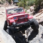
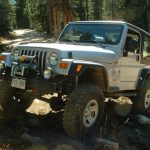
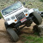
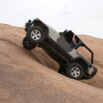
The Rock Hill was a blast. We all took our time going down it and we were often surrounded by hikers. It was pretty busy at times. The top of the Rock Hill was chunky and then it got crazy the farther you went. There were some very tippy sections near the bottom of the obstacle but everyone stayed safe and there were no issues.

It was a quick trip the rest of the way down to the St. Vrain Creek crossing. We found more hikers down there along with other vehicles across the creek. There was another vehicle behind us, someone who was meeting the vehicles in front of us.

We discussed the creek crossing for a bit. Monica pulled off before the creek and she was the only one not to go through it. It was rushing hard and the water was deep but everyone else had big tires and they made it through to the other side. There was enough room over there to let the other group back through and they headed back up the trail.

We had heard from many people about the rest of the trail on the other side of the creek and it sounded best to avoid it. So everyone came back through the creek. Water rushed over Jeffrey's door sills and filled his Jeep up with water on the way through the first time, so the second time he had his doors in. The water was deeper coming back through the creek but no one had any issues.

It was a blast going back up the Rock Hill and for some reason it was easier for everyone. It didn't seem as tippy, so that might have been the reason. We all enjoyed it and we knew it would be a hill we'd see on a regular basis.

Once we got back to the crossroads we finally headed over to Miller Rock. We all parked and hung out while some people in the group hiked up to the top of the rock. The weather was still perfect so we were having a nice time just hanging out and chatting.

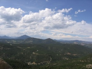
The sun was out as we worked our way down to the ranch, and it made the green trail absolutely gorgeous. There were lots of wildflowers and beautiful meadows and we took lots of pictures. When we got to the gate we passed through and locked it behind us as they had asked. We didn't see any people on our way through the ranch but we saw lots of cars. It looks like a really nice camp.

When we got to the road we left Jim and Mark C. as they headed for home. The rest of us went to explore a new area and a new trail. Miller Rock was a great time, especially with all of the spurs. It rained like crazy in town but we didn't get a single raindrop. We'll be back!

airing_down
aspens
austin_down_the_rock_hill_part_1
austin_down_the_rock_hill_part_2
austin_down_the_rock_hill_part_3
austin_down_the_rock_hill_part_4
blue_sky
bob_down_the_rock_hill_part_1
bob_down_the_rock_hill_part_2
bob_down_the_rock_hill_part_3
bob_down_the_rock_hill_part_4
bob_down_the_rock_hill_part_5
bob_down_the_rock_hill_part_6
bob_down_the_rock_hill_part_7
bumpy_start
clearing
climbing
crazy_tree
down_to_the_camp
early_trail
easier_climb
first_rocks
green_meadow
greens
jeeps_at_miller_rock
jeffrey_down_the_rock_hill_part_1
jeffrey_down_the_rock_hill_part_2
jeffrey_down_the_rock_hill_part_3
jeffrey_down_the_rock_hill_part_4
jeffrey_down_the_rock_hill_part_5
jim_down_the_rock_hill_part_1
jim_down_the_rock_hill_part_2
jim_down_the_rock_hill_part_3
jim_down_the_rock_hill_part_4
jim_down_the_rock_hill_part_5
jim_roger_and_mark_c
katie_down_the_rock_hill_part_1
katie_down_the_rock_hill_part_2
katie_down_the_rock_hill_part_3
katie_down_the_rock_hill_part_4
katie_down_the_rock_hill_part_5
katie_down_the_rock_hill_part_6
katie_down_the_rock_hill_part_7
katie_down_the_rock_hill_part_8
katie_down_the_rock_hill_part_9
katie_on_the_trail
lonnie_and_jeeps
loose
lunch
mark_c_down_the_rock_hill_part_1
mark_c_down_the_rock_hill_part_2
mark_c_down_the_rock_hill_part_3
mark_c_down_the_rock_hill_part_4
mark_c_down_the_rock_hill_part_5
mark_c_down_the_rock_hill_part_6
mark_c_down_the_rock_hill_part_7
mark_c_down_the_rock_hill_part_8
mark_u_and_jeffrey_on_miller_rock_part_1
mark_u_and_jeffrey_on_miller_rock_part_2
mark_u_down_the_rock_hill_part_1
mark_u_down_the_rock_hill_part_2
mark_u_down_the_rock_hill_part_3
mark_u_down_the_rock_hill_part_4
mark_u_down_the_rock_hill_part_5
mark_u_down_the_rock_hill_part_6
mark_u_down_the_rock_hill_part_7
mark_u_down_the_rock_hill_part_8
mark_u_down_the_rock_hill_part_9
matt_down_the_rock_hill_part_1
matt_down_the_rock_hill_part_2
matt_down_the_rock_hill_part_3
matt_down_the_rock_hill_part_4
matt_down_the_rock_hill_part_5
matt_down_the_rock_hill_part_6
matt_down_the_rock_hill_part_7
matt_down_the_rock_hill_part_8
meadow_view
mike_down_the_rock_hill_part_1
mike_down_the_rock_hill_part_2
mike_down_the_rock_hill_part_3
mike_down_the_rock_hill_part_4
mike_down_the_rock_hill_part_5
mike_down_the_rock_hill_part_6
mike_down_the_rock_hill_part_7
miller_rock_parking_part_1
miller_rock_parking_part_2
miller_rock
monica_down_the_rock_hill_part_1
monica_down_the_rock_hill_part_2
monica_down_the_rock_hill_part_3
monica_down_the_rock_hill_part_4
monica_down_the_rock_hill_part_5
monica_down_the_rock_hill_part_6
monica_down_the_rock_hill_part_7
monica_down_the_rock_hill_part_8
monica_down_the_rock_hill_part_9
monica_turning_around
narrow_climb
out_of_the_trees
rock_hill
roger_down_the_rock_hill_part_1
roger_down_the_rock_hill_part_2
roger_down_the_rock_hill_part_3
roger_down_the_rock_hill_part_4
roger_down_the_rock_hill_part_5
roger_down_the_rock_hill_part_6
roger_relaxing
shadows
small_ledges
st_vrain_creek_crossing
st_vrain_creek
stormy_skies
taking_a_break
to_miller_rock
tree_roots
up_miller_rock_part_1
up_miller_rock_part_2
weird_hanging_rock

Reports from Other Days: 2

Use the arrows or dots to flip through the previews of the other reports for Miller Rock. Click one of them to read more and see all of the photos from that day.

July 3, 2005

Led by Monica I.
This has to be the most difficult trail to find in the state. Luckily Sean knew the way and we found the trailhead without any difficulty. We pulled onto the trail and past the house to air down. It was pretty chilly (about 60 degrees) and raining off and on…
«
  • 1
  • 2
Join Us!
If you aren’t a Member or Subscriber, you can’t see all of the content on this site. Get membership information to see why this site is best when you join and log in

Information for Subscribers

When you log in you’ll see more information here:

  • Recent Community Forum posts
  • Recent polls
  • Upcoming Events you can attend
  • Links to online users

© 2000-2023 · TrailDamage.com · Terms and Conditions · About · Contact
Trail information is only accurate on the date posted. Trails may have changed or closed since that date. Use this information for historical purposes only.
Contact the Forest Service or Bureau of Land Management for up-to-date trail information.

/* ----------------------------------------- */ /* View slug: reports-other-reports-for-same-trail-slider - start */ /* ----------------------------------------- */ /* place the prev/next controls on the sides */ .td-transition-controls .wpv-filter-next-link, .td-transition-controls .wpv-filter-previous-link { border: none; font-size: 300%; position: absolute; top: 70px; } .td-transition-controls .wpv-filter-previous-link { left: 0; } .td-transition-controls .wpv-filter-next-link { right: 0; } /* center the page selector horizonatally */ .td-transition-controls ul.wpv_pagination_dots { text-align: center; margin-top: 10px; } /* center the page selector horizonatally */ .td-transition-controls ul.wpv_pagination_dots li.wpv_pagination_dots_item, .td-transition-controls .wpv_pagination_dots li a { display: inline-block; float: none; } /* remove the default styles */ .td-transition-controls .wpv_pagination_dots li a { text-decoration: none; border-bottom: none; } .td-slider-container { padding: 0 25px; margin-bottom: 20px; position: relative; width:100%; display:table; } .td-slides { position: relative; } .td-slides-image { float:left; display:table-cell; } .td-slides-image img { border:1px solid #c0c0c0; } .td-slides-content { padding:4px 4px 4px 10px; border-top:1px solid #c0c0c0; border-right:1px solid #c0c0c0; border-bottom:1px solid #c0c0c0; display:table-cell; height:227px; overflow:hidden; } .td-slides-content h3 { margin-top:8px; } .td-slides-leader { font-size:smaller; margin-top:4px; } /* ----------------------------------------- */ /* View slug: reports-other-reports-for-same-trail-slider - end */ /* ----------------------------------------- */
/* ----------------------------------------- */ /* Content Template: Template for a Single Report - start */ /* ----------------------------------------- */ .entry-header { display:none; } .entry-content h1 { margin-top:16px; padding-top:0; } h1 a { color:#222; } h1 a:hover { color:#666; } p.entry-meta { font-size:small; } #report-body-spacer { clear:both; width:100%; height:20px; } #addtoany-bar { margin-bottom:2em; text-align:center; } .category-reports .post-info .author, .post-info .date { display: none; } .addthis_recommended_horizontal { text-align:center !important; } /* ----------------------------------------- */ /* Content Template: Template for a Single Report - end */ /* ----------------------------------------- */ /* ----------------------------------------- */ /* Content Template: Loop item in REPORTS Runners - start */ /* ----------------------------------------- */ #runners-container { width:100%; clear:both; } .runner { border:1px solid #c0c0c0; margin:0 6px 6px 0; float:left; width:49%; height:81px; } .runner-image { float: left; } .runner-image img { margin:2px 10px 0 2px; height:75px; width:75px; } .runner-name { text-transform:uppercase; } .runner-name a { color:#222; } .runner-name a:hover { color:#666; } .runner-vehicle { font-size:small; } @media only screen and (max-width: 768px) { .runner { width:100%; } } /* ----------------------------------------- */ /* Content Template: Loop item in REPORTS Runners - end */ /* ----------------------------------------- */