TrailDamage.com

Photos, videos and information about 4x4 trails in Colorado and Utah

  • Trails
    • Colorado
    • Utah
  • Reports
    • Featured Photos
    • Featured Videos
    • Reports Calendar
  • Members
  • Search
  • Trail Damage Winners
  • FAQ
  • Community
  • Upcoming Events
  • Membership
  • Log In
  • Facebook
  • Instagram
  • RSS
  • Twitter
  • YouTube

Lost Canyon 081018

October 18, 2008 by Monica

Lost Canyon

Trail Run on October 18, 2008
Report and photos by Monica I., Trail Leader
View trail information for Lost Canyon

Monica I.
Red 2010 Jeep Wrangler Rubicon
Julie M.
Green 2012 Jeep Wrangler Unlimited Rubicon
Mike S.
Silver 2004 Jeep Wrangler Rubicon
Bill S.
Yellow 2020 Jeep Wrangler Rubicon
Mark U.
Red 1989 Jeep Wrangler
Matt K.
White 2016 Jeep Wrangler Unlimited Rubicon
Walt S.
Gray 2022 Jeep Wrangler Unlimited Rubicon 392
Mark F.
Blue 2002 Jeep Wrangler
Roger R.
Gray 2021 Jeep Wrangler Rubicon 4xe

This was a new one for the group, though Roger had done it before. It was one of his favorites, and he enjoyed expertly showing us around. We spent so much time enjoying the trail that we ran out of time to do Flume Creek, a trail right next to Lost Canyon. There's always next year.

We found the trailhead behind the gas station in Granite, and we were soon headed down the very dusty and easy dirt road to the main trail. We were soon heading up, happy to get out of the dust.

The early switchbacks for the first half of the trail were nice and mellow. We were really surrounded by aspen trees for a good portion of it, and they made a canopy over the trail in many places. Unfortunately, the leaves had already fallen off of them. We were already talking about coming back in future years to see them all yellow.

We wondered if the trail would always be this easy, but at about the halfway mark it suddenly got more difficult. It was right at some mining equipment. Up to this point, it would be a really good trail for an SUV driver new to mountain driving.

It got steeper and rockier as we climbed above timberline. We first took the little spur to the gate at the Gold Basin Mine, and we all got out to enjoy the scenery. We saw a couple of trucks at the very top, high above the mine, and we knew that was our destination.

We started climbing up to the top, and we soon passed the trucks. We were headed out to Roger's favorite overlook, Overlook 3 on the map. We didn't get out again until we were all parked there.

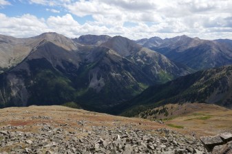
The views were amazing! It was windy and a little chilly, but not too bad at all. We could see the Clear Creek Reservoir and Lost Canyon below us, as well as a lot of surrounding mountains.

We headed back out, stopping again at the big cabin. It was almost like a duplex, with two doors and a wall between the two big rooms. Where it was situated was very windy, and we couldn't imagine why someone would build such a big structure there.

We didn't hike down to the mine, but Roger told us about it. We had more to explore. We soon headed over to the Overlook 2 area.

This part was the fun and challenging section of the trail. It was a steep climb, and soon we found the trail covered in snow. Luckily, there were bare patches of snow where the tire tracks were that formed the trail, so we could see where it was. Everyone had a good time slipping and sliding to the top.

We stayed at Overlook 2 for awhile, really enjoying the views. We were at over 13,000 feet, which was a real treat. We were all reminded of the rocks at the top of Twin Cone. It was extremely scenic, and we were glad we could get to the top.

We headed down and then over to the smaller cabin and Overlook 1. The views from Overlook 1 were also good, but not as good as the ones we'd seen. Still, it offered a new view of the area to the west and north.

The sun was going down already, an unfortunate part of wheeling in the fall. It looked like we weren't going to get to Flume Creek. We headed down and aired up in the daylight, which was nice.

Six of us even made it to Quincy's in Leadville for prime rib, one of our favorite places to eat dinner after a long day of wheeling. There was hardly anyone there, and we were waited on hand and foot. We all talked about the biggest wheeling adventures we'd ever had, and it was a great time. It wasn't too long before we were headed for home. What a great day!

across_the_tundra
aspens_part_2
aspens_part_3
aspens
basin_view
big_cabin_part_1
big_cabin_part_2
big_cabin_part_3
big_cabin_part_4
bill_on_the_trail
blue_sky
cabin_near_overlook_1
clear_creek_reservoir
climbing_above_timberline
curves
down_a_short_hill
early_trail
easier_trail_ends_here
gold_basin_mine_gate
gold_basin_mine_signs
high_trail
julie_on_the_trail
layers
little_snow
mark_u_on_the_trail
parked_at_overlook_3
random_old_cabin
start_of_rougher_trail
start_of_the_trail
switchback_view
to_overlook_3_part_2
to_overlook_3
trail_signs
trailhead
turn_uphill
view_behind_us
view_from_overlook_1
view_from_overlook_2_part_1
view_from_overlook_2_part_2
view_from_overlook_2_part_3
view_from_overlook_2_part_4
view_from_overlook_2_part_5
view_from_overlook_2_part_6
view_from_overlook_2_part_7
view_from_overlook_3_part_1
view_from_overlook_3_part_2
view_from_overlook_3_part_3
view_from_the_big_cabin_part_1
view_from_the_big_cabin_part_2
walt_on_the_trail

Reports from Other Days: 2

Use the arrows or dots to flip through the previews of the other reports for Lost Canyon. Click one of them to read more and see all of the photos from that day.

August 18, 2018

Led by Monica I.
The weather started out pretty nasty in the morning, but it was early in the afternoon and the skies were blue with puffy clouds.  We had a quick discussion and decided to continue our day by heading over to Lost Canyon.  We were already aired down, so we headed straight…
»
  • 1
  • 2
Join Us!
If you aren’t a Member or Subscriber, you can’t see all of the content on this site. Get membership information to see why this site is best when you join and log in

Information for Subscribers

When you log in you’ll see more information here:

  • Recent Community Forum posts
  • Recent polls
  • Upcoming Events you can attend
  • Links to online users

© 2000-2023 · TrailDamage.com · Terms and Conditions · About · Contact
Trail information is only accurate on the date posted. Trails may have changed or closed since that date. Use this information for historical purposes only.
Contact the Forest Service or Bureau of Land Management for up-to-date trail information.

/* ----------------------------------------- */ /* View slug: reports-other-reports-for-same-trail-slider - start */ /* ----------------------------------------- */ /* place the prev/next controls on the sides */ .td-transition-controls .wpv-filter-next-link, .td-transition-controls .wpv-filter-previous-link { border: none; font-size: 300%; position: absolute; top: 70px; } .td-transition-controls .wpv-filter-previous-link { left: 0; } .td-transition-controls .wpv-filter-next-link { right: 0; } /* center the page selector horizonatally */ .td-transition-controls ul.wpv_pagination_dots { text-align: center; margin-top: 10px; } /* center the page selector horizonatally */ .td-transition-controls ul.wpv_pagination_dots li.wpv_pagination_dots_item, .td-transition-controls .wpv_pagination_dots li a { display: inline-block; float: none; } /* remove the default styles */ .td-transition-controls .wpv_pagination_dots li a { text-decoration: none; border-bottom: none; } .td-slider-container { padding: 0 25px; margin-bottom: 20px; position: relative; width:100%; display:table; } .td-slides { position: relative; } .td-slides-image { float:left; display:table-cell; } .td-slides-image img { border:1px solid #c0c0c0; } .td-slides-content { padding:4px 4px 4px 10px; border-top:1px solid #c0c0c0; border-right:1px solid #c0c0c0; border-bottom:1px solid #c0c0c0; display:table-cell; height:227px; overflow:hidden; } .td-slides-content h3 { margin-top:8px; } .td-slides-leader { font-size:smaller; margin-top:4px; } /* ----------------------------------------- */ /* View slug: reports-other-reports-for-same-trail-slider - end */ /* ----------------------------------------- */
/* ----------------------------------------- */ /* Content Template: Template for a Single Report - start */ /* ----------------------------------------- */ .entry-header { display:none; } .entry-content h1 { margin-top:16px; padding-top:0; } h1 a { color:#222; } h1 a:hover { color:#666; } p.entry-meta { font-size:small; } #report-body-spacer { clear:both; width:100%; height:20px; } #addtoany-bar { margin-bottom:2em; text-align:center; } .category-reports .post-info .author, .post-info .date { display: none; } .addthis_recommended_horizontal { text-align:center !important; } /* ----------------------------------------- */ /* Content Template: Template for a Single Report - end */ /* ----------------------------------------- */ /* ----------------------------------------- */ /* Content Template: Loop item in REPORTS Runners - start */ /* ----------------------------------------- */ #runners-container { width:100%; clear:both; } .runner { border:1px solid #c0c0c0; margin:0 6px 6px 0; float:left; width:49%; height:81px; } .runner-image { float: left; } .runner-image img { margin:2px 10px 0 2px; height:75px; width:75px; } .runner-name { text-transform:uppercase; } .runner-name a { color:#222; } .runner-name a:hover { color:#666; } .runner-vehicle { font-size:small; } @media only screen and (max-width: 768px) { .runner { width:100%; } } /* ----------------------------------------- */ /* Content Template: Loop item in REPORTS Runners - end */ /* ----------------------------------------- */