TrailDamage.com

Photos, videos and information about 4x4 trails in Colorado and Utah

  • Trails
    • Colorado
    • Utah
  • Reports
    • Featured Photos
    • Featured Videos
    • Reports Calendar
  • Members
  • Search
  • Trail Damage Winners
  • FAQ
  • Community
  • Upcoming Events
  • Membership
  • Log In
  • Facebook
  • Instagram
  • RSS
  • Twitter
  • YouTube

Lockhart Basin 210605

June 5, 2021 by Matt Kuczborski

Lockhart Basin

Trail Run on June 5, 2021
Report and photos by Matt K., Trail Leader
View trail information for Lockhart Basin

Julie M.
Green 2012 Jeep Wrangler Unlimited Rubicon
Niko K.
Gray 2017 Jeep Wrangler Unlimited
Matt K.
White 2016 Jeep Wrangler Unlimited Rubicon

We drove the Lockhart Basin trail after Hurrah Pass during our weekend in Moab. They had forecasted temperatures in the triple digits, so when we started Lockhart Basin it was getting pretty hot outside! We prepared ourselves to be on this trail for a long time, as the trail is over 37 miles long.

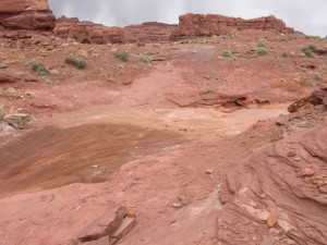
The beginning of Lockhart Basin is a lot more difficult than the end. Going up into the wash and getting out of the canyon was very fun. In some places it would get a little tippy with big rocks just to add more excitement.

At the top of the climb out of the canyon, there was a cliff wall above us that we drove along for some time. That cliff was the only area that had any type of shade, so we stopped and had lunch in the middle of the road on Lockhart Basin trail. We did not see anyone on the trail, but if some would have come down the trail, we would have had to move for them.

After lunch, we came upon a few people on bikes way out in the middle of Lockhart Basin. There were three people on bikes but they were separate from each other.

As we were approaching the end of the harder part of Lockhart Basin, we stopped and looked for an aircraft crash site we'd read about. Only Matt and Corrigan braved the heat to walk around looking, and after a short time they found parts of the aircraft that had crashed here. Corrigan had worked hard on finding these airplane pieces strewn about the crash site!

Shortly after the aircraft crash area, the Lockhart Basin trail smoothed out a lot and we were able to make a lot faster progress.

After a hill climb, we came to a creek crossing that was all dried out this year. After the creek crossing, Lockhart Basin turned into an easy drive dirt road all the way to the end.

At the end near a campground, we stopped to air back up for the long drive back to Moab on paved roads.

IMG_8605
IMG_8606
IMG_8607
IMG_8608
IMG_8609
IMG_8610
IMG_8611
IMG_8612
IMG_8613
IMG_8614
IMG_8615
IMG_8616
IMG_8617
IMG_8619
IMG_8620
IMG_8621
IMG_8623
IMG_8625
IMG_8626
IMG_8627
IMG_8629
IMG_8630
IMG_8631
IMG_8632
IMG_8633
IMG_8635
IMG_8636
IMG_8637
IMG_8639
IMG_8640
IMG_8641
IMG_8642
IMG_8643
IMG_8644
IMG_8645
IMG_8646
IMG_8648
IMG_8649
IMG_8652
IMG_8654
IMG_8655
IMG_8656
IMG_8658
IMG_8659
IMG_8660
IMG_8662
IMG_8663
IMG_8664
IMG_8665
IMG_8667
IMG_8668
IMG_8669
IMG_8670
IMG_8671
IMG_8672
IMG_8675
IMG_8676
IMG_8677
IMG_8678
IMG_8679
IMG_8680
IMG_8681
IMG_8682
IMG_8684
IMG_8685
IMG_8686
IMG_8687
IMG_8688
IMG_8689
IMG_8690
IMG_8692
IMG_8693
IMG_8694
IMG_8696
IMG_8697
IMG_8698
IMG_8702
IMG_8703
IMG_8704
IMG_8705
IMG_8706
IMG_8707
IMG_8708
IMG_8709
IMG_8710

Reports from Other Days: 3

Use the arrows or dots to flip through the previews of the other reports for Lockhart Basin. Click one of them to read more and see all of the photos from that day.

April 9, 2008

Led by Mike S.
We hit the trailhead after running Chicken Corners and were immediately lost. There were apparently a lot of people that had made the same mistake as we did because we were on a well traveled trail but it soon dead ended. The side trip wasn’t a total loss however, as…
« »
  • 1
  • 2
  • 3
Join Us!
If you aren’t a Member or Subscriber, you can’t see all of the content on this site. Get membership information to see why this site is best when you join and log in

Information for Subscribers

When you log in you’ll see more information here:

  • Recent Community Forum posts
  • Recent polls
  • Upcoming Events you can attend
  • Links to online users

© 2000-2023 · TrailDamage.com · Terms and Conditions · About · Contact
Trail information is only accurate on the date posted. Trails may have changed or closed since that date. Use this information for historical purposes only.
Contact the Forest Service or Bureau of Land Management for up-to-date trail information.

/* ----------------------------------------- */ /* View slug: reports-other-reports-for-same-trail-slider - start */ /* ----------------------------------------- */ /* place the prev/next controls on the sides */ .td-transition-controls .wpv-filter-next-link, .td-transition-controls .wpv-filter-previous-link { border: none; font-size: 300%; position: absolute; top: 70px; } .td-transition-controls .wpv-filter-previous-link { left: 0; } .td-transition-controls .wpv-filter-next-link { right: 0; } /* center the page selector horizonatally */ .td-transition-controls ul.wpv_pagination_dots { text-align: center; margin-top: 10px; } /* center the page selector horizonatally */ .td-transition-controls ul.wpv_pagination_dots li.wpv_pagination_dots_item, .td-transition-controls .wpv_pagination_dots li a { display: inline-block; float: none; } /* remove the default styles */ .td-transition-controls .wpv_pagination_dots li a { text-decoration: none; border-bottom: none; } .td-slider-container { padding: 0 25px; margin-bottom: 20px; position: relative; width:100%; display:table; } .td-slides { position: relative; } .td-slides-image { float:left; display:table-cell; } .td-slides-image img { border:1px solid #c0c0c0; } .td-slides-content { padding:4px 4px 4px 10px; border-top:1px solid #c0c0c0; border-right:1px solid #c0c0c0; border-bottom:1px solid #c0c0c0; display:table-cell; height:227px; overflow:hidden; } .td-slides-content h3 { margin-top:8px; } .td-slides-leader { font-size:smaller; margin-top:4px; } /* ----------------------------------------- */ /* View slug: reports-other-reports-for-same-trail-slider - end */ /* ----------------------------------------- */
/* ----------------------------------------- */ /* Content Template: Template for a Single Report - start */ /* ----------------------------------------- */ .entry-header { display:none; } .entry-content h1 { margin-top:16px; padding-top:0; } h1 a { color:#222; } h1 a:hover { color:#666; } p.entry-meta { font-size:small; } #report-body-spacer { clear:both; width:100%; height:20px; } #addtoany-bar { margin-bottom:2em; text-align:center; } .category-reports .post-info .author, .post-info .date { display: none; } .addthis_recommended_horizontal { text-align:center !important; } /* ----------------------------------------- */ /* Content Template: Template for a Single Report - end */ /* ----------------------------------------- */ /* ----------------------------------------- */ /* Content Template: Loop item in REPORTS Runners - start */ /* ----------------------------------------- */ #runners-container { width:100%; clear:both; } .runner { border:1px solid #c0c0c0; margin:0 6px 6px 0; float:left; width:49%; height:81px; } .runner-image { float: left; } .runner-image img { margin:2px 10px 0 2px; height:75px; width:75px; } .runner-name { text-transform:uppercase; } .runner-name a { color:#222; } .runner-name a:hover { color:#666; } .runner-vehicle { font-size:small; } @media only screen and (max-width: 768px) { .runner { width:100%; } } /* ----------------------------------------- */ /* Content Template: Loop item in REPORTS Runners - end */ /* ----------------------------------------- */