TrailDamage.com

Photos, videos and information about 4x4 trails in Colorado and Utah

  • Trails
    • Colorado
    • Utah
  • Reports
    • Featured Photos
    • Featured Videos
    • Reports Calendar
  • Members
  • Search
  • Trail Damage Winners
  • FAQ
  • Community
  • Upcoming Events
  • Membership
  • Log In
  • Facebook
  • Instagram
  • RSS
  • Twitter
  • YouTube

Lockhart Basin 080409

April 9, 2008 by Mike Shannon

Lockhart Basin

Trail Run on April 9, 2008
Report and photos by Mike S., Trail Leader
View trail information for Lockhart Basin

Mike S.
Silver 2004 Jeep Wrangler Rubicon
Walt S.
Gray 2022 Jeep Wrangler Unlimited Rubicon 392
Roger R.
Gray 2021 Jeep Wrangler Rubicon 4xe

We hit the trailhead after running Chicken Corners and were immediately lost. There were apparently a lot of people that had made the same mistake as we did because we were on a well traveled trail but it soon dead ended. The side trip wasn't a total loss however, as it did take us down a tippy ledge into the streambed. After back-tracking we quickly found where we went wrong and headed up the correct canyon.

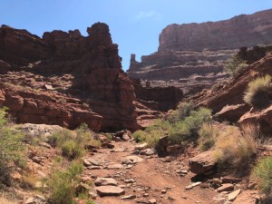
The trail was all pretty easy, suitable for a stock SUV for the most part. The one obstacle that did cause some problems was a rocky climb in the narrow canyon within a mile of the start of the trail. Roger had a little difficulty when he went through. Mike got hung up with a rock under his transfer case skid plate and rocks at his control arm mounts. After some good spotting, and some rock stacking he was through the tough part. Walt then came through, learning from the others' mistakes. He took a line that put his passenger-side tires up on the ledge on the passenger's side of the Jeep and walked right through without so much as a tire chirp.

After that, the trail was relatively easy and we found ourselves in two-wheel drive for most of the rest of the trip. The views were great and the weather cooperated by being cool but with no rain, and there was no dust because of the rains earlier. We met no other traffic on the trail until we were almost at the end when we met one pickup with a bicyclist heading in.

The weather was beginning to look threatening by the time we hit the end of the trail, with very dark clouds rolling in from the west. The Needles Overlook was completely lost in the clouds although it had been sunlit when we passed beneath it. We aired up, reconnected and hit the pavement for the long trip back to Moab. It wasn't long before it began to snow, and then sleet, and then hail. Soon the pavement was white and we were driving very cautiously as it was quite slick. We were glad that we hadn't been hit with those conditions while on the trail. It was an interesting end to a fantastic day.

mike_down_a_ledge_part_1
mike_down_a_ledge_part_2
roger_down_a_ledge
roger_through_rocks
roger_up_a_wash
start_of_the_trail
walt_down_a_ledge
walt_in_a_tippy_part
walt_through_rocks_part_1
walt_through_rocks_part_2

Reports from Other Days: 3

Use the arrows or dots to flip through the previews of the other reports for Lockhart Basin. Click one of them to read more and see all of the photos from that day.

June 5, 2021

Led by Matt K.
We drove the Lockhart Basin trail after Hurrah Pass during our weekend in Moab. They had forecasted temperatures in the triple digits, so when we started Lockhart Basin it was getting pretty hot outside! We prepared ourselves to be on this trail for a long time, as the trail is…
»
  • 1
  • 2
  • 3
Join Us!
If you aren’t a Member or Subscriber, you can’t see all of the content on this site. Get membership information to see why this site is best when you join and log in

Information for Subscribers

When you log in you’ll see more information here:

  • Recent Community Forum posts
  • Recent polls
  • Upcoming Events you can attend
  • Links to online users

© 2000-2022 · TrailDamage.com · Terms and Conditions · About · Contact
Trail information is only accurate on the date posted. Trails may have changed or closed since that date. Use this information for historical purposes only.
Contact the Forest Service or Bureau of Land Management for up-to-date trail information.

/* ----------------------------------------- */ /* View slug: reports-other-reports-for-same-trail-slider - start */ /* ----------------------------------------- */ /* place the prev/next controls on the sides */ .td-transition-controls .wpv-filter-next-link, .td-transition-controls .wpv-filter-previous-link { border: none; font-size: 300%; position: absolute; top: 70px; } .td-transition-controls .wpv-filter-previous-link { left: 0; } .td-transition-controls .wpv-filter-next-link { right: 0; } /* center the page selector horizonatally */ .td-transition-controls ul.wpv_pagination_dots { text-align: center; margin-top: 10px; } /* center the page selector horizonatally */ .td-transition-controls ul.wpv_pagination_dots li.wpv_pagination_dots_item, .td-transition-controls .wpv_pagination_dots li a { display: inline-block; float: none; } /* remove the default styles */ .td-transition-controls .wpv_pagination_dots li a { text-decoration: none; border-bottom: none; } .td-slider-container { padding: 0 25px; margin-bottom: 20px; position: relative; width:100%; display:table; } .td-slides { position: relative; } .td-slides-image { float:left; display:table-cell; } .td-slides-image img { border:1px solid #c0c0c0; } .td-slides-content { padding:4px 4px 4px 10px; border-top:1px solid #c0c0c0; border-right:1px solid #c0c0c0; border-bottom:1px solid #c0c0c0; display:table-cell; height:227px; overflow:hidden; } .td-slides-content h3 { margin-top:8px; } .td-slides-leader { font-size:smaller; margin-top:4px; } /* ----------------------------------------- */ /* View slug: reports-other-reports-for-same-trail-slider - end */ /* ----------------------------------------- */
/* ----------------------------------------- */ /* Content Template: Template for a Single Report - start */ /* ----------------------------------------- */ .entry-header { display:none; } .entry-content h1 { margin-top:16px; padding-top:0; } h1 a { color:#222; } h1 a:hover { color:#666; } p.entry-meta { font-size:small; } #report-body-spacer { clear:both; width:100%; height:20px; } #addtoany-bar { margin-bottom:2em; text-align:center; } .category-reports .post-info .author, .post-info .date { display: none; } .addthis_recommended_horizontal { text-align:center !important; } /* ----------------------------------------- */ /* Content Template: Template for a Single Report - end */ /* ----------------------------------------- */ /* ----------------------------------------- */ /* Content Template: Loop item in REPORTS Runners - start */ /* ----------------------------------------- */ #runners-container { width:100%; clear:both; } .runner { border:1px solid #c0c0c0; margin:0 6px 6px 0; float:left; width:49%; height:81px; } .runner-image { float: left; } .runner-image img { margin:2px 10px 0 2px; height:75px; width:75px; } .runner-name { text-transform:uppercase; } .runner-name a { color:#222; } .runner-name a:hover { color:#666; } .runner-vehicle { font-size:small; } @media only screen and (max-width: 768px) { .runner { width:100%; } } /* ----------------------------------------- */ /* Content Template: Loop item in REPORTS Runners - end */ /* ----------------------------------------- */