TrailDamage.com

Photos, videos and information about 4x4 trails in Colorado and Utah

  • Trails
    • Colorado
    • Utah
  • Reports
    • Featured Photos
    • Featured Videos
    • Reports Calendar
  • Members
  • Search
  • Trail Damage Winners
  • FAQ
  • Community
  • Upcoming Events
  • Membership
  • Log In
  • Facebook
  • Instagram
  • RSS
  • Twitter
  • YouTube

Keystone Gulch 080816

August 16, 2008 by Monica

Keystone Gulch

Trail Run on August 16, 2008
Report and photos by Monica I., Trail Leader
View trail information for Keystone Gulch

Don W.
Silver 2005 Jeep Wrangler Rubicon
Brian S.
Blue 1997 Jeep Wrangler
Mark F.
Blue 2002 Jeep Wrangler
Bill S.
Yellow 2020 Jeep Wrangler Rubicon
Gary R.
Yellow 1978 Jeep CJ-7
Mike S.
Silver 2004 Jeep Wrangler Rubicon
Michael M.
Black 2006 Jeep Wrangler Unlimited Rubicon
Walt S.
Gray 2022 Jeep Wrangler Unlimited Rubicon 392
Mark U.
Red 1989 Jeep Wrangler
Ryan S.
Red 1999 Jeep Wrangler
Bob S.
Green 1997 Jeep Wrangler

The weekend before was sunny and gorgeous, like it always is in August in Colorado. But then the weather took a crazy turn. The prediction was a high of 47 degrees in Breckenridge, where were were headed. We planned on getting higher in elevation than Breckenridge, so we were planning for some chilly weather. It was raining in town, but we found more than that on the mountain.

We started in Keystone, planning on running up Keystone Mountain. The trail ended up being closed for the moment as they worked on some ski equipment, so we had to skip it this time. We'll come back for it some other time.

We headed off to Keystone Gulch, and found a fairly mellow trail. It was cool seeing the ski lifts and runs up close, with no snow on them. It was raining, though, and pretty chilly.

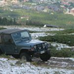
When we got to the spur, we crossed the creek and started up. As we climbed, the rain changed to snow. Snow! In August! It was even sticking on the trail and on the trees. It was crazy, but very cool to see.

We went through quite a few switchbacks in the trees, expecting to finally climb out. But then the spur just ended. We had quite a few vehicles, making it difficult to get everyone turned around. But we did it, and we were soon headed back down to the main trail.

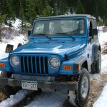
We kept going on the main trail, following the gulch. Then the trail turned up the mountain, and we climbed. We soon ended up above timberline, and we found the buildings from the Erickson Mine. The trail had a couple of inches of snow on it, and the rocks underneath our tires were slippery.

Everyone found a place to stop, and we all got out to appreciate the scenery. It was gorgeous. And then the clouds disappeared and we were surrounded by blue skies and a warm sun. It still looked like it was raining below us, but we were in fabulous weather above the clouds.

We had a great lunch, all lined up along the road and facing the valley below us. Even though we were on a couple of inches of snow, it wasn't cold. We couldn't have asked for a more scenic and enjoyable lunch.

We soon headed back down, and as we descended we drove back into the bad weather. It was raining back in town, and it looked like it had never stopped. It was pretty cool to get out and above the bad weather. We headed off for Breckenridge and the rest of our trails for the day.

beaver_dam
big_view
climbing
deer
early_trail
erickson_mine
forest_service_sign
hole_in_the_wall
keystone_mountain
kiosk
looks_like_winter
michael_in_snow
mine_buildings_part_1
mine_buildings_part_2
no_4x4_vehicles
ski_sign
snow_on_the_spur
start_of_the_spur
tracks_in_snow
trailhead_signs
trailhead
up_the_spur
view_from_the_mine
water_crossing_at_the_spur
Join Us!
If you aren’t a Member or Subscriber, you can’t see all of the content on this site. Get membership information to see why this site is best when you join and log in

Information for Subscribers

When you log in you’ll see more information here:

  • Recent Community Forum posts
  • Recent polls
  • Upcoming Events you can attend
  • Links to online users

© 2000-2022 · TrailDamage.com · Terms and Conditions · About · Contact
Trail information is only accurate on the date posted. Trails may have changed or closed since that date. Use this information for historical purposes only.
Contact the Forest Service or Bureau of Land Management for up-to-date trail information.

/* ----------------------------------------- */ /* View slug: reports-other-reports-for-same-trail-slider - start */ /* ----------------------------------------- */ /* place the prev/next controls on the sides */ .td-transition-controls .wpv-filter-next-link, .td-transition-controls .wpv-filter-previous-link { border: none; font-size: 300%; position: absolute; top: 70px; } .td-transition-controls .wpv-filter-previous-link { left: 0; } .td-transition-controls .wpv-filter-next-link { right: 0; } /* center the page selector horizonatally */ .td-transition-controls ul.wpv_pagination_dots { text-align: center; margin-top: 10px; } /* center the page selector horizonatally */ .td-transition-controls ul.wpv_pagination_dots li.wpv_pagination_dots_item, .td-transition-controls .wpv_pagination_dots li a { display: inline-block; float: none; } /* remove the default styles */ .td-transition-controls .wpv_pagination_dots li a { text-decoration: none; border-bottom: none; } .td-slider-container { padding: 0 25px; margin-bottom: 20px; position: relative; width:100%; display:table; } .td-slides { position: relative; } .td-slides-image { float:left; display:table-cell; } .td-slides-image img { border:1px solid #c0c0c0; } .td-slides-content { padding:4px 4px 4px 10px; border-top:1px solid #c0c0c0; border-right:1px solid #c0c0c0; border-bottom:1px solid #c0c0c0; display:table-cell; height:227px; overflow:hidden; } .td-slides-content h3 { margin-top:8px; } .td-slides-leader { font-size:smaller; margin-top:4px; } /* ----------------------------------------- */ /* View slug: reports-other-reports-for-same-trail-slider - end */ /* ----------------------------------------- */
/* ----------------------------------------- */ /* Content Template: Template for a Single Report - start */ /* ----------------------------------------- */ .entry-header { display:none; } .entry-content h1 { margin-top:16px; padding-top:0; } h1 a { color:#222; } h1 a:hover { color:#666; } p.entry-meta { font-size:small; } #report-body-spacer { clear:both; width:100%; height:20px; } #addtoany-bar { margin-bottom:2em; text-align:center; } .category-reports .post-info .author, .post-info .date { display: none; } .addthis_recommended_horizontal { text-align:center !important; } /* ----------------------------------------- */ /* Content Template: Template for a Single Report - end */ /* ----------------------------------------- */ /* ----------------------------------------- */ /* Content Template: Loop item in REPORTS Runners - start */ /* ----------------------------------------- */ #runners-container { width:100%; clear:both; } .runner { border:1px solid #c0c0c0; margin:0 6px 6px 0; float:left; width:49%; height:81px; } .runner-image { float: left; } .runner-image img { margin:2px 10px 0 2px; height:75px; width:75px; } .runner-name { text-transform:uppercase; } .runner-name a { color:#222; } .runner-name a:hover { color:#666; } .runner-vehicle { font-size:small; } @media only screen and (max-width: 768px) { .runner { width:100%; } } /* ----------------------------------------- */ /* Content Template: Loop item in REPORTS Runners - end */ /* ----------------------------------------- */