TrailDamage.com

Photos, videos and information about 4x4 trails in Colorado and Utah

  • Trails
    • Colorado
    • Utah
  • Reports
    • Featured Photos
    • Featured Videos
    • Reports Calendar
  • Members
  • Search
  • Trail Damage Winners
  • FAQ
  • Community
  • Upcoming Events
  • Membership
  • Log In
  • Facebook
  • Instagram
  • RSS
  • Twitter
  • YouTube

Ballard Road 101009

October 9, 2010 by Matt Kuczborski

Ballard Road

Trail Run on October 9, 2010
Report and photos by Matt K., Trail Leader
View trail information for Ballard Road

Walt S.
Gray 2022 Jeep Wrangler Unlimited Rubicon 392
Matt K.
White 2016 Jeep Wrangler Unlimited Rubicon
Gary R.
Yellow 1978 Jeep CJ-7
Austin C.
Khaki 2004 Jeep Wrangler Unlimited Rubicon
Ray S.
Green 2008 Jeep Wrangler Rubicon
Roger R.
Gray 2021 Jeep Wrangler Rubicon 4xe
Mike S.
Silver 2004 Jeep Wrangler Rubicon
Ryan S.
Red 1999 Jeep Wrangler

It was a gorgeous morning, one that was perfect for a day of exploring. We ended up getting a late start due to alarm clock issues, but we were eventually on our way. There were eight in our group and it was a little difficult keeping everyone together as we drove through Loveland. Once we were out of town it was a peaceful drive in the hills.

Ballard Road was the first of four trails we planned on exploring on this run and we had a mellow start to our day. We aired down and disconnected at a big turnout shortly before the trailhead on Buckhorn Road, and then we were on our way.

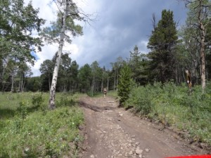
The trail started as an easy road with "no trespassing" signs posted on each side. We made sure not to stop in this area. We climbed for quite a while, passing what appeared to be driveways. We continued to climb, passing a spur on one of the switchbacks that looked very tempting. But we stayed on the trail, determined to reach the top.

We passed a couple of spurs, but at about five miles up the trail there were some mines on the GPS and a spur off to our right so we decided to explore it. This turned out to be the best part of the trail. This spur climbed higher in elevation and had some rocks to negotiate, but the best part was the lean that really had Gary's attention the whole way up. It turned out that the spur looped back onto itself, so we got to experience the lean again as we headed back to the main trail.

We knew there were mines nearby on the spur, but we could not see them from the trail. We decided not to waste time looking for them, so we kept driving.

Once back onto the main trail we continued to climb toward the top, passing piles of wood on the side of the trail. They looked to be edgings from a sawmill.

The trail ends at a very large pile of wood. We managed to get all eight vehicles parked and decided it would be a good place for lunch. After a relaxing lunch, we backtracked down the mountain. When we reached the spur on the switchback, we stopped for a moment and took a vote if we should explore the spur or not. We decided we needed to get to the next trail. Some research discovered that this spur is called Greer Road. We definitely need to check this out the next time we are in the area and have more time.

Our group headed back to the trailhead looking forward to our next trail.

airing_down_part_1
airing_down_part_2
airing_down_part_3
fall_colors
follow_129
glimpse_of_fall_colors
going_up_ballard_road
little_chunky
lunch_part_1
lunch_part_2
lunch_part_3
matt_and_gary
mike_on_the_trail
old_sawmill_operation
ray_and_mike
rocky_spur
roger_at_the_top
ryan_at_the_top
walt_on_the_trail

Reports from Other Days: 2

Use the arrows or dots to flip through the previews of the other reports for Ballard Road. Click one of them to read more and see all of the photos from that day.

July 20, 2013

Led by Monica I.
Though we had already done more than half of Pennock Pass, it was Ballard Road and Greer Road South we were really looking forward to for the day. We found the trailhead easily enough and headed south. It would be a day of wandering around. We saw the trailhead for…
»
  • 1
  • 2
Join Us!
If you aren’t a Member or Subscriber, you can’t see all of the content on this site. Get membership information to see why this site is best when you join and log in

Information for Subscribers

When you log in you’ll see more information here:

  • Recent Community Forum posts
  • Recent polls
  • Upcoming Events you can attend
  • Links to online users

© 2000-2023 · TrailDamage.com · Terms and Conditions · About · Contact
Trail information is only accurate on the date posted. Trails may have changed or closed since that date. Use this information for historical purposes only.
Contact the Forest Service or Bureau of Land Management for up-to-date trail information.

/* ----------------------------------------- */ /* View slug: reports-other-reports-for-same-trail-slider - start */ /* ----------------------------------------- */ /* place the prev/next controls on the sides */ .td-transition-controls .wpv-filter-next-link, .td-transition-controls .wpv-filter-previous-link { border: none; font-size: 300%; position: absolute; top: 70px; } .td-transition-controls .wpv-filter-previous-link { left: 0; } .td-transition-controls .wpv-filter-next-link { right: 0; } /* center the page selector horizonatally */ .td-transition-controls ul.wpv_pagination_dots { text-align: center; margin-top: 10px; } /* center the page selector horizonatally */ .td-transition-controls ul.wpv_pagination_dots li.wpv_pagination_dots_item, .td-transition-controls .wpv_pagination_dots li a { display: inline-block; float: none; } /* remove the default styles */ .td-transition-controls .wpv_pagination_dots li a { text-decoration: none; border-bottom: none; } .td-slider-container { padding: 0 25px; margin-bottom: 20px; position: relative; width:100%; display:table; } .td-slides { position: relative; } .td-slides-image { float:left; display:table-cell; } .td-slides-image img { border:1px solid #c0c0c0; } .td-slides-content { padding:4px 4px 4px 10px; border-top:1px solid #c0c0c0; border-right:1px solid #c0c0c0; border-bottom:1px solid #c0c0c0; display:table-cell; height:227px; overflow:hidden; } .td-slides-content h3 { margin-top:8px; } .td-slides-leader { font-size:smaller; margin-top:4px; } /* ----------------------------------------- */ /* View slug: reports-other-reports-for-same-trail-slider - end */ /* ----------------------------------------- */
/* ----------------------------------------- */ /* Content Template: Template for a Single Report - start */ /* ----------------------------------------- */ .entry-header { display:none; } .entry-content h1 { margin-top:16px; padding-top:0; } h1 a { color:#222; } h1 a:hover { color:#666; } p.entry-meta { font-size:small; } #report-body-spacer { clear:both; width:100%; height:20px; } #addtoany-bar { margin-bottom:2em; text-align:center; } .category-reports .post-info .author, .post-info .date { display: none; } .addthis_recommended_horizontal { text-align:center !important; } /* ----------------------------------------- */ /* Content Template: Template for a Single Report - end */ /* ----------------------------------------- */ /* ----------------------------------------- */ /* Content Template: Loop item in REPORTS Runners - start */ /* ----------------------------------------- */ #runners-container { width:100%; clear:both; } .runner { border:1px solid #c0c0c0; margin:0 6px 6px 0; float:left; width:49%; height:81px; } .runner-image { float: left; } .runner-image img { margin:2px 10px 0 2px; height:75px; width:75px; } .runner-name { text-transform:uppercase; } .runner-name a { color:#222; } .runner-name a:hover { color:#666; } .runner-vehicle { font-size:small; } @media only screen and (max-width: 768px) { .runner { width:100%; } } /* ----------------------------------------- */ /* Content Template: Loop item in REPORTS Runners - end */ /* ----------------------------------------- */