TrailDamage.com

Photos, videos and information about 4x4 trails in Colorado and Utah

  • Trails
    • Colorado
    • Utah
  • Reports
    • Featured Photos
    • Featured Videos
    • Reports Calendar
  • Members
  • Search
  • Trail Damage Winners
  • FAQ
  • Community
  • Upcoming Events
  • Membership
  • Log In
  • Facebook
  • Instagram
  • RSS
  • Twitter
  • YouTube

Swan River 060916

September 16, 2006 by Monica

Swan River

Trail Run on September 16, 2006
Report and photos by Monica I., Trail Leader
View trail information for Swan River

Mike S.
Silver 2004 Jeep Wrangler Rubicon
Walt S.
Gray 2022 Jeep Wrangler Unlimited Rubicon 392
Roger R.
Gray 2021 Jeep Wrangler Rubicon 4xe
Cheryl W.
Orange 2006 Jeep Wrangler Unlimited Rubicon
Michael M.
Black 2006 Jeep Wrangler Unlimited Rubicon
Gary R.
Yellow 1978 Jeep CJ-7
Dane R.
Silver 2007 Jeep Wrangler Rubicon
Monica I.
Red 2010 Jeep Wrangler Rubicon

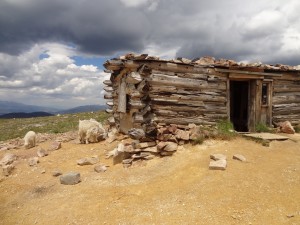
We only ran the middle fork of the Swan River this time. First we ran the bottom half, then did S.O.B. Hill to the top and then back down. We had lunch at the cabin there, then headed out to do the top half of the middle fork of the Swan River.

We stopped for only a little while in Swandyke, to check out the buried truck. It has been a year since we first saw it, and we still don't know its history. Like last year, it was driving us crazy wondering how it got there. It's definitely one of the weirdest things we've seen out on the trail.

It was snowing, but it wasn't really sticking until we started to get to about timberline. When we came out of the trees we could see that the trail and all of the mountains were about half-covered in snow. It was still snowing, and snowing really hard. It made everything a bit slick and wet, but because only half of any given section was snowy it wasn't too bad.

The top part of the middle fork is pretty steep in places, but we weren't really sliding around much, if at all. It would have been very bad on street tires, though.

We finally got to the top and breathed a sigh of relief. We worked our way over to the top of Radical Hill, and we met up with three Jeeps coming the other way. We talked with them briefly and they said they had run Red Cone and Radical Hill and that it wasn't too bad. They were on their way to S.O.B. Hill, and we confirmed that they were headed in the right direction.

When we could finally see Red Cone we were all very happy that we hadn't been on it on that day. It looked really slick and scary.

We all decided that we're not quite ready for winter! We headed off to Radical Hill and hoped it wouldn't be too snowy.

at_the_top
bottom_of_middle_fork
curves
fall_colors
gary_in_swandyke
mellow_trail
michael_in_swandyke
mike_in_swandyke
monica_in_swandyke
mountain_range
mountain_view
on_the_trail
open_area
rocky_section_part_1
rocky_section_part_2
roger_in_swandyke
snow_covered_trail
snowing_ahead
snowy_climb_above_timberline
swandyke_cabin
swandyke_truck_part_1
swandyke_truck_part_2
through_trees
to_the_top
view_back_toward_the_trailhead
walt_in_swandyke

Reports from Other Days: 3

Use the arrows or dots to flip through the previews of the other reports for Swan River. Click one of them to read more and see all of the photos from that day.

July 26, 2014

Led by Monica I.
We came off of Georgia Pass and it was lightly raining as we headed up the Middle Fork of the Swan River trail. There were a few people camping near the start, and we wondered how the mosquitoes were treating them. It wasn’t long before the trail started climbing up…
»
  • 1
  • 2
  • 3
Join Us!
If you aren’t a Member or Subscriber, you can’t see all of the content on this site. Get membership information to see why this site is best when you join and log in

Information for Subscribers

When you log in you’ll see more information here:

  • Recent Community Forum posts
  • Recent polls
  • Upcoming Events you can attend
  • Links to online users

© 2000-2022 · TrailDamage.com · Terms and Conditions · About · Contact
Trail information is only accurate on the date posted. Trails may have changed or closed since that date. Use this information for historical purposes only.
Contact the Forest Service or Bureau of Land Management for up-to-date trail information.

/* ----------------------------------------- */ /* View slug: reports-other-reports-for-same-trail-slider - start */ /* ----------------------------------------- */ /* place the prev/next controls on the sides */ .td-transition-controls .wpv-filter-next-link, .td-transition-controls .wpv-filter-previous-link { border: none; font-size: 300%; position: absolute; top: 70px; } .td-transition-controls .wpv-filter-previous-link { left: 0; } .td-transition-controls .wpv-filter-next-link { right: 0; } /* center the page selector horizonatally */ .td-transition-controls ul.wpv_pagination_dots { text-align: center; margin-top: 10px; } /* center the page selector horizonatally */ .td-transition-controls ul.wpv_pagination_dots li.wpv_pagination_dots_item, .td-transition-controls .wpv_pagination_dots li a { display: inline-block; float: none; } /* remove the default styles */ .td-transition-controls .wpv_pagination_dots li a { text-decoration: none; border-bottom: none; } .td-slider-container { padding: 0 25px; margin-bottom: 20px; position: relative; width:100%; display:table; } .td-slides { position: relative; } .td-slides-image { float:left; display:table-cell; } .td-slides-image img { border:1px solid #c0c0c0; } .td-slides-content { padding:4px 4px 4px 10px; border-top:1px solid #c0c0c0; border-right:1px solid #c0c0c0; border-bottom:1px solid #c0c0c0; display:table-cell; height:227px; overflow:hidden; } .td-slides-content h3 { margin-top:8px; } .td-slides-leader { font-size:smaller; margin-top:4px; } /* ----------------------------------------- */ /* View slug: reports-other-reports-for-same-trail-slider - end */ /* ----------------------------------------- */
/* ----------------------------------------- */ /* Content Template: Template for a Single Report - start */ /* ----------------------------------------- */ .entry-header { display:none; } .entry-content h1 { margin-top:16px; padding-top:0; } h1 a { color:#222; } h1 a:hover { color:#666; } p.entry-meta { font-size:small; } #report-body-spacer { clear:both; width:100%; height:20px; } #addtoany-bar { margin-bottom:2em; text-align:center; } .category-reports .post-info .author, .post-info .date { display: none; } .addthis_recommended_horizontal { text-align:center !important; } /* ----------------------------------------- */ /* Content Template: Template for a Single Report - end */ /* ----------------------------------------- */ /* ----------------------------------------- */ /* Content Template: Loop item in REPORTS Runners - start */ /* ----------------------------------------- */ #runners-container { width:100%; clear:both; } .runner { border:1px solid #c0c0c0; margin:0 6px 6px 0; float:left; width:49%; height:81px; } .runner-image { float: left; } .runner-image img { margin:2px 10px 0 2px; height:75px; width:75px; } .runner-name { text-transform:uppercase; } .runner-name a { color:#222; } .runner-name a:hover { color:#666; } .runner-vehicle { font-size:small; } @media only screen and (max-width: 768px) { .runner { width:100%; } } /* ----------------------------------------- */ /* Content Template: Loop item in REPORTS Runners - end */ /* ----------------------------------------- */