TrailDamage.com

Photos, videos and information about 4x4 trails in Colorado and Utah

  • Trails
    • Colorado
    • Utah
  • Reports
    • Featured Photos
    • Featured Videos
    • Reports Calendar
  • Members
  • Search
  • Trail Damage Winners
  • FAQ
  • Community
  • Upcoming Events
  • Membership
  • Log In
  • Facebook
  • Instagram
  • RSS
  • Twitter
  • YouTube

Swan River 050827

August 27, 2005 by Monica

Swan River

Trail Run on August 27, 2005
Report and photos by Monica I., Trail Leader
View trail information for Swan River

Gary R.
Yellow 1978 Jeep CJ-7
Bob R.
Green 2003 Jeep Wrangler Rubicon
Monica I.
Red 2010 Jeep Wrangler Rubicon
Bob S.
Green 1997 Jeep Wrangler
Rob C.
Silver 2003 Jeep Wrangler Rubicon
Walt S.
Gray 2018 Jeep Wrangler Unlimited Rubicon

We made a loop of these trails along with S.O.B. Hill and had a really great day filled with scenery and challenges. Even though the day started out sunny it ended up being rainy and chilly for most of our trip, but these trails ended up being good ones for that kind of weather. These trails were a great addition to our list.

We started out by going up the Middle Fork and we turned at the intersection for S.O.B. Hill a couple miles into the trail. We were glad to have this intersection in the GPS, as it was hard to find. It was a right turn marked with a brown Forest Service sign with no numbers or any other clues.

We did S.O.B. Hill (see the other report for details about that trail) and had lunch at the top of Glacier Ridge. Then we went down to Georgia Pass and turned to go down the South Fork of the Swan River. From Glacier Ridge and Georgia Pass we could see the fork in the road on the North Fork as well as the top of Wise Mountain -- our destinations.

The South Fork was pretty mellow and we got down to Tiger Road really quickly. Then we backtracked just a little to go up the North Fork.

We had come down the North Fork the weekend before on our way from Radical Hill, and we were looking forward to driving up the hill instead of down it. It is a really long hill, and steep the entire time. Luckily we didn't run across anyone coming down, as it would have been difficult to pass.

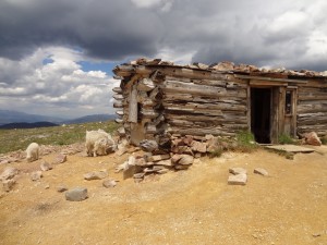
We went all the way up Wise Mountain and hung out for a bit at the cabin, enjoying the view. It was clear enough to see Breckenridge and Keystone ski runs, and it wasn't as windy as it was the last time we were there. There were some people staying at the cabin but they were off enjoying the day.

Walt had been overheating on the way up the North Fork so he let his Blazer cool down for a bit. There was an odd smell, too, so we hoped for the best.

We headed off of Wise Mountain and up to the fork. The right part of the fork is an illegal route so we went up the left side. Both sides are very steep and loose, and the left side is a switchback right next to a cliff. It was definitely intimidating, but not too particularly difficult.

Walt decided he would play it safe and get off the mountain, and Jim volunteered to make sure he got home safely. They turned off at Deer Creek to take the easiest and shortest way down, while the rest of us continued on the Swan River loop. Walt made it home okay but he had issues all the way home.

The sign pointing the way to the trail at the top of the Middle Fork was down, so we put it back up in the supporting rocks, then we headed down. It was misty and rainy and it made the lush basin next to Sheep Mountain very green and gorgeous. There was a spur that took off to the left at the bottom of the basin but we decided to save that exploration for another time, so we continued on.

When we got to the old ghost town site of Swandyke we got out to check it out and stretch our legs. We noticed a tire half buried in the dirt and thought it was odd, but not nearly as odd as it was when we realized it was still attached to an entire truck.

The truck or car is buried upside down and you can see part of the frame, the half-tire, and some of both axles. It has been here for a very long time. We wondered about the history of it, and how it came to be there. Is the driver in there?

The well-preserved cabin in Swandyke isn't much compared to the one on Wise Mountain, but it's still very cool. This used to be a big town, with a huge hotel. It's hard to believe, with all of the trees there now.

We worked our way down to the intersection for S.O.B. Hill and took it again, planning to run back up and down it again before we left for the day. It had been raining all afternoon so this attempt was much different than our run in the sunny morning, and it was a blast!

These trails are beautiful and we had a really nice time. I'm sure we'll do these once a year.

airing_down
big_view
bob_r_in_swandyke
bob_r_on_wise_mountain
bob_s_in_swandyke_cabin
breckenridge_ski_resort
cabin_at_the_crossroads_to_north_fork
cabin_on_wise_mountain
climbing_the_fork
coming_down_middle_fork
coming_from_wise_mountain
dirt_road
down_middle_fork
early_trail
elk_part_1
elk_part_2
fork_in_the_distance
fork
gary_at_the_gate
gary_on_the_north_fork
georgia_pass_seen_from_wise_mountain
jim_on_wise_mountain
mine_on_north_fork
monica_on_wise_mountain
mountain_view
north_fork
old_house
on_the_trail
open_meadow
parked_in_swandyke
parked_on_wise_mountain
permanent_snow
rain
red_cone
river_crossing
river_on_middle_fork
rob_on_wise_mountain
sheep_mountain_basin
sheep_mountain
sign_down
sign_near_radical_hill
snow_in_august
steps_on_north_fork
swan_river
swandyke_cabin
swandyke_truck_part_1
swandyke_truck_part_2
swandyke_truck_part_3
swandyke_truck_part_4
swandyke_truck_part_5
tony_mine
trail_ahead
trail_in_the_distance
walt_cooling_down
walt_on_wise_mountain
way_above_timberline
wrong_way

Reports from Other Days: 3

Use the arrows or dots to flip through the previews of the other reports for Swan River. Click one of them to read more and see all of the photos from that day.

July 26, 2014

Led by Monica I.
We came off of Georgia Pass and it was lightly raining as we headed up the Middle Fork of the Swan River trail. There were a few people camping near the start, and we wondered how the mosquitoes were treating them. It wasn’t long before the trail started climbing up…
»
  • 1
  • 2
  • 3
Join Us!
If you aren’t a Member or Subscriber, you can’t see all of the content on this site. Get membership information to see why this site is best when you join and log in

Information for Subscribers

When you log in you’ll see more information here:

  • Recent Community Forum posts
  • Recent polls
  • Upcoming Events you can attend
  • Links to online users

© 2000-2021 · TrailDamage.com · Terms and Conditions · About · Contact
Trail information is only accurate on the date posted. Trails may have changed or closed since that date. Use this information for historical purposes only.
Contact the Forest Service or Bureau of Land Management for up-to-date trail information.

/* ----------------------------------------- */ /* View slug: reports-other-reports-for-same-trail-slider - start */ /* ----------------------------------------- */ /* place the prev/next controls on the sides */ .td-transition-controls .wpv-filter-next-link, .td-transition-controls .wpv-filter-previous-link { border: none; font-size: 300%; position: absolute; top: 70px; } .td-transition-controls .wpv-filter-previous-link { left: 0; } .td-transition-controls .wpv-filter-next-link { right: 0; } /* center the page selector horizonatally */ .td-transition-controls ul.wpv_pagination_dots { text-align: center; margin-top: 10px; } /* center the page selector horizonatally */ .td-transition-controls ul.wpv_pagination_dots li.wpv_pagination_dots_item, .td-transition-controls .wpv_pagination_dots li a { display: inline-block; float: none; } /* remove the default styles */ .td-transition-controls .wpv_pagination_dots li a { text-decoration: none; border-bottom: none; } .td-slider-container { padding: 0 25px; margin-bottom: 20px; position: relative; width:100%; display:table; } .td-slides { position: relative; } .td-slides-image { float:left; display:table-cell; } .td-slides-image img { border:1px solid #c0c0c0; } .td-slides-content { padding:4px 4px 4px 10px; border-top:1px solid #c0c0c0; border-right:1px solid #c0c0c0; border-bottom:1px solid #c0c0c0; display:table-cell; height:227px; overflow:hidden; } .td-slides-content h3 { margin-top:8px; } .td-slides-leader { font-size:smaller; margin-top:4px; } /* ----------------------------------------- */ /* View slug: reports-other-reports-for-same-trail-slider - end */ /* ----------------------------------------- */
/* ----------------------------------------- */ /* Content Template: Template for a Single Report - start */ /* ----------------------------------------- */ .entry-header { display:none; } .entry-content h1 { margin-top:16px; padding-top:0; } h1 a { color:#222; } h1 a:hover { color:#666; } p.entry-meta { font-size:small; } #report-body-spacer { clear:both; width:100%; height:20px; } #addtoany-bar { margin-bottom:2em; text-align:center; } .category-reports .post-info .author, .post-info .date { display: none; } .addthis_recommended_horizontal { text-align:center !important; } /* ----------------------------------------- */ /* Content Template: Template for a Single Report - end */ /* ----------------------------------------- */ /* ----------------------------------------- */ /* Content Template: Loop item in REPORTS Runners - start */ /* ----------------------------------------- */ #runners-container { width:100%; clear:both; } .runner { border:1px solid #c0c0c0; margin:0 6px 6px 0; float:left; width:49%; height:81px; } .runner-image { float: left; } .runner-image img { margin:2px 10px 0 2px; height:75px; width:75px; } .runner-name { text-transform:uppercase; } .runner-name a { color:#222; } .runner-name a:hover { color:#666; } .runner-vehicle { font-size:small; } @media only screen and (max-width: 768px) { .runner { width:100%; } } /* ----------------------------------------- */ /* Content Template: Loop item in REPORTS Runners - end */ /* ----------------------------------------- */