TrailDamage.com

Photos, videos and information about 4x4 trails in Colorado and Utah

  • Trails
    • Colorado
    • Utah
  • Reports
    • Featured Photos
    • Featured Videos
    • Reports Calendar
  • Members
  • Search
  • Trail Damage Winners
  • FAQ
  • Community
  • Upcoming Events
  • Membership
  • Log In
  • Facebook
  • Instagram
  • RSS
  • Twitter
  • YouTube

Strike Ravine 051007

October 7, 2005 by Monica

Strike Ravine

Trail Run on October 7, 2005
Report and photos by Monica I., Trail Leader
View trail information for Strike Ravine

Monica I.
Red 2010 Jeep Wrangler Rubicon
Cheryl W.
Orange 2006 Jeep Wrangler Unlimited Rubicon
Eric B.
Green 2000 Jeep Wrangler
Roger R.
Gray 2021 Jeep Wrangler Rubicon 4xe
Ladd G.
Green 2003 Jeep Wrangler Rubicon
Mike S.
Silver 2004 Jeep Wrangler Rubicon
Bob S.
Green 1997 Jeep Wrangler
Matt F.
Silver 2000 Jeep Wrangler

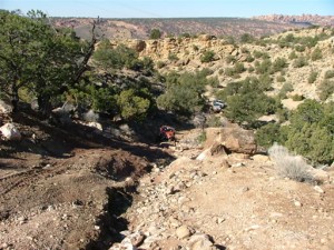
It was frustrating for a good portion of the day as we explored nearly every spur on the trail, following it until it dead ended. We missed an important turn, and instead worked our way across the area to Area BFE instead of around it. Still, we had a good time finding our way.

We found the trailhead easily enough, and it was good to have a large area to air down and get ready. After we started, the first thing we did was miss the campsite. We went up the hill and it didn't look very well used when we got to the top, so we turned around and went back down.

The Big Ugly hill after the campsite was a blast, and everyone had a good time clawing their way to the top.

Once we got to the next ridge we could see trails across the way but we had a hard time figuring out how to get to them. It turned out they were the wrong trails anyway, but they were still fun. We had to have gone down at least 5 spurs that ended at a fence or just ended.

We were following the tracks of some big 4x4 vehicles, but it turned out they were lost too. They went down every spur and turned around, just like we did.

Finally we got over the next ridge and down into a valley. There we found an old trail that was closed. It hadn't been used in awhile, but it looked like it was a fun one. We thought it may have been Lower Helldorado (that trail was closed in late 2003) but it turned out that wasn't it. We still have no idea what it was. We had lunch and enjoyed the sunshine.

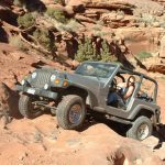
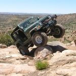
The climb out of the ravine was a blast, though. It started out as a very rocky series of ledges, and near the top there was a ledge that had a deep hole at the start. Monica left a lot of rubber on it, but everyone else who followed did fine. Until Ladd.

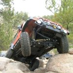
Ladd got a little sideways on it and managed to get extremely tippy, with his back tire in the hole. He held on with both hands as everyone got him back down to earth. With a bunch of people on a strap attached to his bumper and Bob hanging on like a monkey, Ladd slowly backed off of it to safety.

We kept going, coming down a huge hill as a couple of nicely built Cherokees came down from the other side. It turns out these were the two we had been following, and it was their first time there.

At the bottom of the ravine was the Helldorado trail (formerly Upper Helldorado). We walked a bit of it, amazed that people could do it. It was much too big for our Jeeps.

The Cherokees were broken, so we loaned them some tools and hung around for a bit. When they were done, we climbed up out of the ravine and found ourselves in the main part Area BFE, where we played some more.

Hopefully the next time on this trail will be easier, and we'll be able to see all of it.

airing_down
big_ugly
big_view
bob_up_a_hill
cheryl_close_up
cheryl_in_the_ravine_part_1
cheryl_in_the_ravine_part_2
cheryl_in_the_ravine_part_3
cheryl_in_the_ravine_part_4
cheryl_in_the_ravine_part_5
cheryl_on_the_trail
cheryl_up_a_hill
chunky_slickrock_hill
down_a_shelf_road
eric_down_the_trail
eric_in_the_ravine_part_1
eric_in_the_ravine_part_2
eric_in_the_ravine_part_3
eric_on_the_trail
eric_up_a_hill
eric_up_ledges
everyone_lost
geo
helldorado_closed
helldorado_entrance_part_1
helldorado_entrance_part_2
helldorado_obstacle_2
helldorado_obstacle_3_part_1
helldorado_obstacle_3_part_2
helldorado_obstacle_4_part_1
helldorado_obstacle_4_part_2
helldorado_sign
jeeps
ladd_in_the_ravine_part_1
ladd_in_the_ravine_part_2
ladd_in_the_ravine_part_3
ladd_in_the_ravine_part_4
ladd_in_the_ravine_part_5
ladd_in_the_ravine_part_6
ladd_in_the_ravine_part_7
ladd_on_the_rough_ledge
ladd_up_a_hill
ledges
matt_in_the_ravine_part_1
matt_in_the_ravine_part_2
matt_in_the_ravine_part_3
matt_in_the_ravine_part_4
matt_in_the_ravine_part_5
matt_on_the_rough_ledge_part_1
matt_on_the_rough_ledge_part_2
matt_up_a_hill
mellow_road
mike_in_the_ravine
mike_up_a_hill
moab
monica_in_the_ravine_part_1
monica_in_the_ravine_part_2
monica_in_the_ravine_part_3
monica_in_the_ravine_part_4
monica_in_the_ravine_part_5
narrow
on_the_mesa
on_the_trail
out_of_the_ravine
parked_at_helldorado
powerlines
road_closed_part_1
road_closed_part_2
road_closed_part_3
rocky
roger_up_a_hill
rough_ledge
rough_trail
slickrock_blocks
steep_downhill
steep_hill
suicidal_tendencies_sign
through_the_campsite_part_1
through_the_campsite_part_2
tippy
trail_continues
trailhead_part_1
trailhead_part_2
walking_helldorado
wide_road
wrong_way

Report from a Different Day

October 27, 2006

Led by Monica I.
We couldn’t find the trail last year, so this year we were even more prepared. We had lots of maps and more information, but it was still difficult to find the trail at times. Though it is a frustrating trail, the Big Ugly obstacle makes it all worth it. We…
Join Us!
If you aren’t a Member or Subscriber, you can’t see all of the content on this site. Get membership information to see why this site is best when you join and log in

Information for Subscribers

When you log in you’ll see more information here:

  • Recent Community Forum posts
  • Recent polls
  • Upcoming Events you can attend
  • Links to online users

© 2000-2023 · TrailDamage.com · Terms and Conditions · About · Contact
Trail information is only accurate on the date posted. Trails may have changed or closed since that date. Use this information for historical purposes only.
Contact the Forest Service or Bureau of Land Management for up-to-date trail information.

/* ----------------------------------------- */ /* View slug: reports-other-reports-for-same-trail-slider - start */ /* ----------------------------------------- */ /* place the prev/next controls on the sides */ .td-transition-controls .wpv-filter-next-link, .td-transition-controls .wpv-filter-previous-link { border: none; font-size: 300%; position: absolute; top: 70px; } .td-transition-controls .wpv-filter-previous-link { left: 0; } .td-transition-controls .wpv-filter-next-link { right: 0; } /* center the page selector horizonatally */ .td-transition-controls ul.wpv_pagination_dots { text-align: center; margin-top: 10px; } /* center the page selector horizonatally */ .td-transition-controls ul.wpv_pagination_dots li.wpv_pagination_dots_item, .td-transition-controls .wpv_pagination_dots li a { display: inline-block; float: none; } /* remove the default styles */ .td-transition-controls .wpv_pagination_dots li a { text-decoration: none; border-bottom: none; } .td-slider-container { padding: 0 25px; margin-bottom: 20px; position: relative; width:100%; display:table; } .td-slides { position: relative; } .td-slides-image { float:left; display:table-cell; } .td-slides-image img { border:1px solid #c0c0c0; } .td-slides-content { padding:4px 4px 4px 10px; border-top:1px solid #c0c0c0; border-right:1px solid #c0c0c0; border-bottom:1px solid #c0c0c0; display:table-cell; height:227px; overflow:hidden; } .td-slides-content h3 { margin-top:8px; } .td-slides-leader { font-size:smaller; margin-top:4px; } /* ----------------------------------------- */ /* View slug: reports-other-reports-for-same-trail-slider - end */ /* ----------------------------------------- */
/* ----------------------------------------- */ /* Content Template: Template for a Single Report - start */ /* ----------------------------------------- */ .entry-header { display:none; } .entry-content h1 { margin-top:16px; padding-top:0; } h1 a { color:#222; } h1 a:hover { color:#666; } p.entry-meta { font-size:small; } #report-body-spacer { clear:both; width:100%; height:20px; } #addtoany-bar { margin-bottom:2em; text-align:center; } .category-reports .post-info .author, .post-info .date { display: none; } .addthis_recommended_horizontal { text-align:center !important; } /* ----------------------------------------- */ /* Content Template: Template for a Single Report - end */ /* ----------------------------------------- */ /* ----------------------------------------- */ /* Content Template: Loop item in REPORTS Runners - start */ /* ----------------------------------------- */ #runners-container { width:100%; clear:both; } .runner { border:1px solid #c0c0c0; margin:0 6px 6px 0; float:left; width:49%; height:81px; } .runner-image { float: left; } .runner-image img { margin:2px 10px 0 2px; height:75px; width:75px; } .runner-name { text-transform:uppercase; } .runner-name a { color:#222; } .runner-name a:hover { color:#666; } .runner-vehicle { font-size:small; } @media only screen and (max-width: 768px) { .runner { width:100%; } } /* ----------------------------------------- */ /* Content Template: Loop item in REPORTS Runners - end */ /* ----------------------------------------- */