TrailDamage.com

Photos, videos and information about 4x4 trails in Colorado and Utah

  • Trails
    • Colorado
    • Utah
  • Reports
    • Featured Photos
    • Featured Videos
    • Reports Calendar
  • Members
  • Search
  • Trail Damage Winners
  • FAQ
  • Community
  • Upcoming Events
  • Membership
  • Log In
  • Facebook
  • Instagram
  • RSS
  • Twitter
  • YouTube

Spring Canyon Bottom 100520

May 20, 2010 by Monica

Spring Canyon Bottom

Trail Run on May 20, 2010
Report and photos by Monica I., Trail Leader
View trail information for Spring Canyon Bottom

Roger R.
White 2005 Jeep Wrangler Unlimited Rubicon
Julie M.
Green 2012 Jeep Wrangler Unlimited Rubicon
Mark U.
Red 1989 Jeep Wrangler
Bob S.
Green 1997 Jeep Wrangler

It had been awhile since we last saw Spring Canyon Bottom. It's a good trail to run with Hey Joe Canyon, and we really didn't have a great time the last time we were on that trail. However, we had heard that the BLM had the tamerisk somewhat under control in that area, and it was time to check out the trail one more time.

Andrew was still pretty delirious in the morning and didn't get up in time to join us. Robert had some more work to do on his Jeep so he also stayed behind. They ended up running the Trifecta (Poison Spider Mesa, Golden Spike and Gold Bar Rim) but didn't take any pictures.

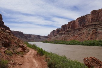
The rest of us found the trailhead easily enough using our GPS track from years ago. We aired down and headed down the easy dirt road. It's definitely an easy trail while you're still above the canyon, but the views are amazing. We made note of Tombstone Butte, a rock we'd be seeing throughout the day.

We were soon at the top of the canyon just before the switchbacks that head down to the bottom. We all got out and enjoyed the views, and it seemed that no one wanted to get too close to the edge. The skies were blue and the temperatures were already pretty warm. It was promising to be a toasty day.

We headed down the switchbacks, enjoying the fun on the way down. It really is a great descent. It always ends too soon, though, and we were quickly at the bottom.

We worked our way through the canyon and soon found the trailhead for Hey Joe Canyon. We passed it, planning on coming back after finishing Spring Canyon Bottom.

The last time we were there, the trail simply got too narrow to continue. We were wondering what we'd find this time around. When we got to the point where we had turned around before, the trail continued around a tippy spot.

We kept driving next to the river and really enjoyed the views. Then the trail just ended at a sign. Luckily, we weren't too stacked up. Julie was first and she turned around at the end and came back to a wide spot in the trail. Then everyone went to the end and turned around, one by one. It worked out very well.

It was really getting hot outside. We all applied more sunscreen and headed off to Hey Joe Canyon to see how it was. Spring Canyon Bottom really is a great trail!

We beat Andrew and Robert back to town by many hours. It was a great day.

airing_down
around_the_bend
big_views_at_the_top
bob_checking_on_the_way_out_of_town
bob_on_the_trail
bowknot_bend
canyon_below
canyon_edge
crack
down_to_the_bottom_part_1
down_to_the_bottom_part_2
down_to_the_bottom_part_3
down_to_the_bottom_part_4
down_to_the_bottom_part_5
down_to_the_bottom_part_6
down_to_the_bottom_part_7
down_to_the_bottom_part_8
down_to_the_bottom_part_9
green_river
hot
julie_taking_pictures
looking_back_up
mellow_trail
parked_at_the_top
sign_at_the_end
start_of_the_trail
starting_down
through_the_canyon
trail_ahead

Reports from Other Days: 2

Use the arrows or dots to flip through the previews of the other reports for Spring Canyon Bottom. Click one of them to read more and see all of the photos from that day.

May 14, 2017

Led by Monica I.
We had a big loop planned for the day that started on Blue Hills Road and ended on Crystal Geyser.  Spring Canyon Bottom would take us through a good portion of the middle of that loop, so we left Highway 313 and headed in.  The morning was crisp and cool,…
»
  • 1
  • 2
Join Us!
If you aren’t a Member or Subscriber, you can’t see all of the content on this site. Get membership information to see why this site is best when you join and log in

Information for Subscribers

When you log in you’ll see more information here:

  • Recent Community Forum posts
  • Recent polls
  • Upcoming Events you can attend
  • Links to online users

© 2000-2021 · TrailDamage.com · Terms and Conditions · About · Contact
Trail information is only accurate on the date posted. Trails may have changed or closed since that date. Use this information for historical purposes only.
Contact the Forest Service or Bureau of Land Management for up-to-date trail information.

/* ----------------------------------------- */ /* View slug: reports-other-reports-for-same-trail-slider - start */ /* ----------------------------------------- */ /* place the prev/next controls on the sides */ .td-transition-controls .wpv-filter-next-link, .td-transition-controls .wpv-filter-previous-link { border: none; font-size: 300%; position: absolute; top: 70px; } .td-transition-controls .wpv-filter-previous-link { left: 0; } .td-transition-controls .wpv-filter-next-link { right: 0; } /* center the page selector horizonatally */ .td-transition-controls ul.wpv_pagination_dots { text-align: center; margin-top: 10px; } /* center the page selector horizonatally */ .td-transition-controls ul.wpv_pagination_dots li.wpv_pagination_dots_item, .td-transition-controls .wpv_pagination_dots li a { display: inline-block; float: none; } /* remove the default styles */ .td-transition-controls .wpv_pagination_dots li a { text-decoration: none; border-bottom: none; } .td-slider-container { padding: 0 25px; margin-bottom: 20px; position: relative; width:100%; display:table; } .td-slides { position: relative; } .td-slides-image { float:left; display:table-cell; } .td-slides-image img { border:1px solid #c0c0c0; } .td-slides-content { padding:4px 4px 4px 10px; border-top:1px solid #c0c0c0; border-right:1px solid #c0c0c0; border-bottom:1px solid #c0c0c0; display:table-cell; height:227px; overflow:hidden; } .td-slides-content h3 { margin-top:8px; } .td-slides-leader { font-size:smaller; margin-top:4px; } /* ----------------------------------------- */ /* View slug: reports-other-reports-for-same-trail-slider - end */ /* ----------------------------------------- */
/* ----------------------------------------- */ /* Content Template: Template for a Single Report - start */ /* ----------------------------------------- */ .entry-header { display:none; } .entry-content h1 { margin-top:16px; padding-top:0; } h1 a { color:#222; } h1 a:hover { color:#666; } p.entry-meta { font-size:small; } #report-body-spacer { clear:both; width:100%; height:20px; } #addtoany-bar { margin-bottom:2em; text-align:center; } .category-reports .post-info .author, .post-info .date { display: none; } .addthis_recommended_horizontal { text-align:center !important; } /* ----------------------------------------- */ /* Content Template: Template for a Single Report - end */ /* ----------------------------------------- */ /* ----------------------------------------- */ /* Content Template: Loop item in REPORTS Runners - start */ /* ----------------------------------------- */ #runners-container { width:100%; clear:both; } .runner { border:1px solid #c0c0c0; margin:0 6px 6px 0; float:left; width:49%; height:81px; } .runner-image { float: left; } .runner-image img { margin:2px 10px 0 2px; height:75px; width:75px; } .runner-name { text-transform:uppercase; } .runner-name a { color:#222; } .runner-name a:hover { color:#666; } .runner-vehicle { font-size:small; } @media only screen and (max-width: 768px) { .runner { width:100%; } } /* ----------------------------------------- */ /* Content Template: Loop item in REPORTS Runners - end */ /* ----------------------------------------- */