TrailDamage.com

Photos, videos and information about 4x4 trails in Colorado and Utah

  • Trails
    • Colorado
    • Utah
  • Reports
    • Featured Photos
    • Featured Videos
    • Reports Calendar
  • Members
  • Search
  • Trail Damage Winners
  • FAQ
  • Community
  • Upcoming Events
  • Membership
  • Log In
  • Facebook
  • Instagram
  • RSS
  • Twitter
  • YouTube

Sand Flats Road 151009

October 9, 2015 by Monica

Sand Flats Road

Trail Run on October 9, 2015
Report and photos by Monica I., Trail Leader
View trail information for Sand Flats Road

Monica I.
Red 2010 Jeep Wrangler Rubicon
Julie M.
Green 2012 Jeep Wrangler Unlimited Rubicon
Roger R.
Gray 2021 Jeep Wrangler Rubicon 4xe
Mike S.
Silver 2004 Jeep Wrangler Rubicon

We'd spent the majority of the day exploring Pinhook Valley next to Castle Valley, all the way up to Miners Basin. We were looking forward to getting on Sand Flats Road so we could look down on where we'd been from the top of Porcupine Rim. We started Sand Flats Road on the eastern end on the La Sal Loop Road.

The beginning of the trail is mellow as it pops in and out of the Manti-La Sal National Forest. It didn't take long at all to get to the Castle Valley overlook. When we got there, we found people camping at the end and getting ready for a bike ride. We imagined that they'd see people up here all day, so it might not be the best place to stay.

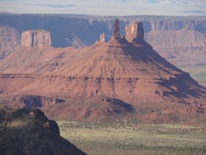
The overlook was breathtaking. The rim is so steep, long, and straight that it's actually difficult to wrap your head around it. The valleys are so huge, and there is so much to see. Round Mountain doesn't look as big from up there, either.

We could see that we were directly across from where we'd stopped at a gate on Porcupine Ranch not too long before we were at this overlook. We could see that whole trail and most of the Pinhook Valley trail. Though we couldn't see the Miners Basin trail, we could see the patch of yellow aspen trees where we'd taken so many pictures that morning. It was cool to see where we'd been earlier, so we hung out there for a while.

The Porcupine Rim trailhead isn't too far down Sand Flats Road from the overlook, and when we got there we got out to discuss doing the Porcupine 4x4 Trail. It was probably too long to get done before the sun went down, but we had time to do one leg of it. We headed down Porcupine Rim to check it out.

The turn to get onto the trail was tight, so we worked on that. Julie ended up going first and wasn't crazy about the tippy obstacle on that end of the Porcupine 4x4 Trail. We didn't know if the rest of the trail was going to be more of the same, so we decided to find out on another day. We worked our way back out to Sand Flats Road.

The trail is scenic and nice, and we saw lots of people enjoying the recreation area. We also saw emergency responders at the campground, which wasn't good. We hoped everyone was okay, and we kept moving. We made a note of the actual trailhead for the Porcupine 4x4 Trail and enjoyed the rest of the drive.

We had to stop at Baby Lion's Back, of course. We all had a good time going up and over the obstacle on the side of the road. It was our first bit of slickrock, and it's funny how it can be very intimidating when you haven't done those steep hills in a while. It's definitely a good time.

We wrapped up our day and headed into town to grab some dinner. It looked like it was going to be a fantastic stay in Moab.

beautiful
between_bumps
castle_valley_overlook_part_1
castle_valley_overlook_part_2
castle_valley_overlook_part_3
castle_valley_overlook_part_4
castle_valley_overlook_part_5
castle_valley_overlook_part_6
castle_valley_overlook_part_7
castle_valley_overlook_part_8
changes
colors
drop_off
easy_trail
fins
julie_and_mike
julie_parked
layers
mellow
moab_below
one_lane
out_to_the_overlook
paved_section
porcupine_4x4_trail
road_sign
rock_formation
roger_on_the_trail
sand_flats_map
shadows
slickrock
southern_pavement
wall_of_rock
warning_sign
wispy_clouds

Report from a Different Day

September 2, 2013

Led by Monica I.
Both of us had been on Sand Flats Road many times to get to the other trails in that area, but neither of us had seen the rest of the trail. We were both happy to go check it out even though we’d aired up already. It was definitely worth…
Join Us!
If you aren’t a Member or Subscriber, you can’t see all of the content on this site. Get membership information to see why this site is best when you join and log in

Information for Subscribers

When you log in you’ll see more information here:

  • Recent Community Forum posts
  • Recent polls
  • Upcoming Events you can attend
  • Links to online users

© 2000-2022 · TrailDamage.com · Terms and Conditions · About · Contact
Trail information is only accurate on the date posted. Trails may have changed or closed since that date. Use this information for historical purposes only.
Contact the Forest Service or Bureau of Land Management for up-to-date trail information.

/* ----------------------------------------- */ /* View slug: reports-other-reports-for-same-trail-slider - start */ /* ----------------------------------------- */ /* place the prev/next controls on the sides */ .td-transition-controls .wpv-filter-next-link, .td-transition-controls .wpv-filter-previous-link { border: none; font-size: 300%; position: absolute; top: 70px; } .td-transition-controls .wpv-filter-previous-link { left: 0; } .td-transition-controls .wpv-filter-next-link { right: 0; } /* center the page selector horizonatally */ .td-transition-controls ul.wpv_pagination_dots { text-align: center; margin-top: 10px; } /* center the page selector horizonatally */ .td-transition-controls ul.wpv_pagination_dots li.wpv_pagination_dots_item, .td-transition-controls .wpv_pagination_dots li a { display: inline-block; float: none; } /* remove the default styles */ .td-transition-controls .wpv_pagination_dots li a { text-decoration: none; border-bottom: none; } .td-slider-container { padding: 0 25px; margin-bottom: 20px; position: relative; width:100%; display:table; } .td-slides { position: relative; } .td-slides-image { float:left; display:table-cell; } .td-slides-image img { border:1px solid #c0c0c0; } .td-slides-content { padding:4px 4px 4px 10px; border-top:1px solid #c0c0c0; border-right:1px solid #c0c0c0; border-bottom:1px solid #c0c0c0; display:table-cell; height:227px; overflow:hidden; } .td-slides-content h3 { margin-top:8px; } .td-slides-leader { font-size:smaller; margin-top:4px; } /* ----------------------------------------- */ /* View slug: reports-other-reports-for-same-trail-slider - end */ /* ----------------------------------------- */
/* ----------------------------------------- */ /* Content Template: Template for a Single Report - start */ /* ----------------------------------------- */ .entry-header { display:none; } .entry-content h1 { margin-top:16px; padding-top:0; } h1 a { color:#222; } h1 a:hover { color:#666; } p.entry-meta { font-size:small; } #report-body-spacer { clear:both; width:100%; height:20px; } #addtoany-bar { margin-bottom:2em; text-align:center; } .category-reports .post-info .author, .post-info .date { display: none; } .addthis_recommended_horizontal { text-align:center !important; } /* ----------------------------------------- */ /* Content Template: Template for a Single Report - end */ /* ----------------------------------------- */ /* ----------------------------------------- */ /* Content Template: Loop item in REPORTS Runners - start */ /* ----------------------------------------- */ #runners-container { width:100%; clear:both; } .runner { border:1px solid #c0c0c0; margin:0 6px 6px 0; float:left; width:49%; height:81px; } .runner-image { float: left; } .runner-image img { margin:2px 10px 0 2px; height:75px; width:75px; } .runner-name { text-transform:uppercase; } .runner-name a { color:#222; } .runner-name a:hover { color:#666; } .runner-vehicle { font-size:small; } @media only screen and (max-width: 768px) { .runner { width:100%; } } /* ----------------------------------------- */ /* Content Template: Loop item in REPORTS Runners - end */ /* ----------------------------------------- */