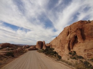
TrailDamage.com

Photos, videos and information about 4x4 trails in Colorado and Utah

  • Trails
    • Colorado
    • Utah
  • Reports
    • Featured Photos
    • Featured Videos
    • Reports Calendar
  • Members
  • Search
  • Trail Damage Winners
  • FAQ
  • Community
  • Upcoming Events
  • Membership
  • Log In
  • Facebook
  • Instagram
  • RSS
  • Twitter
  • YouTube

Sand Flats Road 130902

September 2, 2013 by Monica

Sand Flats Road

Trail Run on September 2, 2013
Report and photos by Monica I., Trail Leader
View trail information for Sand Flats Road

Monica I.
Red 2010 Jeep Wrangler Rubicon
Julie M.
Green 2012 Jeep Wrangler Unlimited Rubicon

Both of us had been on Sand Flats Road many times to get to the other trails in that area, but neither of us had seen the rest of the trail. We were both happy to go check it out even though we'd aired up already. It was definitely worth the trip, and we ran it from the far end into town.

The pavement between the end of Geyser Pass and the end of Sand Flats Road is scenic, but it isn't long. We turned at Jimmy Keen Flat to follow Sand Flats Road. It was a nice drive, winding around the trees.

The trail was curvier as we got a little lower in elevation, and then we saw the turn for Castle Valley Overlook. We'd both spent lots of time in Castle Valley and we knew how pretty it was, so we took it. The spur was much more difficult than the main trail, but it wasn't too bad. We were surprised to find a pit toilet and multiple sites with picnic tables. It would be a pretty cool place for lunch, but not nearly as cool as the end of the trail.

It was another jaw-dropping moment when we saw the views. The whole valley was stretched out before us. There were a few vantage points that allowed us to see the whole area, and it was amazing. We took a lot of pictures. We also noticed that the trail just kept going, right off of the cliff. If it was dark some seriously bad things could happen.

Julie had biked Porcupine Rim before, and she noted that you could start that trail from this overlook spur. There was a sign noting it was The Whole Enchilada. We could have stayed there all day, but now we wanted Mexican food.

The main trail remained easy as it turned west and headed away from the rim. It was still very scenic as it wound its way along. We came to the trailhead for Porcupine Rim and we both recognized it instantly. We stopped to check out the nice map they had there and noted there was a new trail between Porcupine Rim and Fins & Things that we didn't even know about. Next time!

We found yet another surprise at the Juniper Campground, a nice campsite that we didn't know about. It looked brand new, and no one was there. We drove through it and thought it would be a great place to stay as long as the temperatures weren't too high.

As we worked our way west it was a very familiar area. We'd both been there many times, after all. It was interesting to see Sand Flats Road as a destination instead of a means to an end, and it made it very enjoyable.

When we got to Baby Lion's Back we had to do it for old time's sake. We went up to the top and found a Land Rover up there and a driver unsure about the water at the bottom. He pulled to the side and watched us go down the other side. It wasn't a big deal and you could get around it while staying on the trail, so he also came down. Monica drove through the huge puddle and it wasn't deep at all.

Of course, it was a quick trip back out to town from there. The combination of La Sal Pass, Geyser Pass, and Sand Flats Road was the perfect way to do some scenic touring away from the heat of the day. We wrapped up our fall trip to Moab with big grins and happy memories.

behind_the_rocks
between_fins_part_1
between_fins_part_2
between_fins_part_3
big_pine_tree
big_sky
blue_sky
campground_signs
castle_valley_overlook_end
castle_valley_overlook_part_1
castle_valley_overlook_part_2
castle_valley_overlook_part_3
castle_valley_overlook_part_4
castle_valley_overlook_part_5
castle_valley_overlook_part_6
castle_valley_overlook_part_7
castle_valley_overlook_part_8
castle_valley_overlook_part_9
castle_valley_overlook_picnic_part_1
castle_valley_overlook_picnic_part_2
castle_valley_overlook_sign
castle_valley_panorama
colors
dirt_road
down_baby_lions_back
elevations
far_end
fins_part_1
fins_part_2
graded
gravel
julie_and_her_jeep
julie_at_the_castle_valley_overlook
julie_back_from_the_castle_valley_overlook
julie_in_the_sun
julie_on_baby_lions_back_part_1
julie_on_baby_lions_back_part_2
julie_on_baby_lions_back_part_3
julie_on_baby_lions_back_part_4
julie_on_baby_lions_back_part_5
julie_on_baby_lions_back_part_6
julie_on_baby_lions_back_part_7
julie_on_baby_lions_back_part_8
juniper_campground_sign
juniper_campground
la_sal_mountains_part_1
la_sal_mountains_part_2
layers
lumps
map
mellow
monica_at_the_castle_valley_overlook
monica_in_the_sun
new_trail
on_top_of_baby_lions_back
porcupine_rim_pit_toilet
recreation_area_sign
ridge
rock_cut
rock_formations
scenic
scrub
shaded
shades_of_green
slickrock_life
slickrock_trail_parking
slickrock_trail_sign
switchback
the_whole_enchilada
to_castle_valley_overlook_part_1
to_castle_valley_overlook_part_2
utah_and_colorado_mixed
view_from_baby_lions_back

Report from a Different Day

October 9, 2015

Led by Monica I.
We’d spent the majority of the day exploring Pinhook Valley next to Castle Valley, all the way up to Miners Basin. We were looking forward to getting on Sand Flats Road so we could look down on where we’d been from the top of Porcupine Rim. We started Sand Flats…
Join Us!
If you aren’t a Member or Subscriber, you can’t see all of the content on this site. Get membership information to see why this site is best when you join and log in

Information for Subscribers

When you log in you’ll see more information here:

  • Recent Community Forum posts
  • Recent polls
  • Upcoming Events you can attend
  • Links to online users

© 2000-2021 · TrailDamage.com · Terms and Conditions · About · Contact
Trail information is only accurate on the date posted. Trails may have changed or closed since that date. Use this information for historical purposes only.
Contact the Forest Service or Bureau of Land Management for up-to-date trail information.

/* ----------------------------------------- */ /* View slug: reports-other-reports-for-same-trail-slider - start */ /* ----------------------------------------- */ /* place the prev/next controls on the sides */ .td-transition-controls .wpv-filter-next-link, .td-transition-controls .wpv-filter-previous-link { border: none; font-size: 300%; position: absolute; top: 70px; } .td-transition-controls .wpv-filter-previous-link { left: 0; } .td-transition-controls .wpv-filter-next-link { right: 0; } /* center the page selector horizonatally */ .td-transition-controls ul.wpv_pagination_dots { text-align: center; margin-top: 10px; } /* center the page selector horizonatally */ .td-transition-controls ul.wpv_pagination_dots li.wpv_pagination_dots_item, .td-transition-controls .wpv_pagination_dots li a { display: inline-block; float: none; } /* remove the default styles */ .td-transition-controls .wpv_pagination_dots li a { text-decoration: none; border-bottom: none; } .td-slider-container { padding: 0 25px; margin-bottom: 20px; position: relative; width:100%; display:table; } .td-slides { position: relative; } .td-slides-image { float:left; display:table-cell; } .td-slides-image img { border:1px solid #c0c0c0; } .td-slides-content { padding:4px 4px 4px 10px; border-top:1px solid #c0c0c0; border-right:1px solid #c0c0c0; border-bottom:1px solid #c0c0c0; display:table-cell; height:227px; overflow:hidden; } .td-slides-content h3 { margin-top:8px; } .td-slides-leader { font-size:smaller; margin-top:4px; } /* ----------------------------------------- */ /* View slug: reports-other-reports-for-same-trail-slider - end */ /* ----------------------------------------- */
/* ----------------------------------------- */ /* Content Template: Template for a Single Report - start */ /* ----------------------------------------- */ .entry-header { display:none; } .entry-content h1 { margin-top:16px; padding-top:0; } h1 a { color:#222; } h1 a:hover { color:#666; } p.entry-meta { font-size:small; } #report-body-spacer { clear:both; width:100%; height:20px; } #addtoany-bar { margin-bottom:2em; text-align:center; } .category-reports .post-info .author, .post-info .date { display: none; } .addthis_recommended_horizontal { text-align:center !important; } /* ----------------------------------------- */ /* Content Template: Template for a Single Report - end */ /* ----------------------------------------- */ /* ----------------------------------------- */ /* Content Template: Loop item in REPORTS Runners - start */ /* ----------------------------------------- */ #runners-container { width:100%; clear:both; } .runner { border:1px solid #c0c0c0; margin:0 6px 6px 0; float:left; width:49%; height:81px; } .runner-image { float: left; } .runner-image img { margin:2px 10px 0 2px; height:75px; width:75px; } .runner-name { text-transform:uppercase; } .runner-name a { color:#222; } .runner-name a:hover { color:#666; } .runner-vehicle { font-size:small; } @media only screen and (max-width: 768px) { .runner { width:100%; } } /* ----------------------------------------- */ /* Content Template: Loop item in REPORTS Runners - end */ /* ----------------------------------------- */