TrailDamage.com

Photos, videos and information about 4x4 trails in Colorado and Utah

  • Trails
    • Colorado
    • Utah
  • Reports
    • Featured Photos
    • Featured Videos
    • Reports Calendar
  • Members
  • Search
  • Trail Damage Winners
  • FAQ
  • Community
  • Upcoming Events
  • Membership
  • Log In
  • Facebook
  • Instagram
  • RSS
  • Twitter
  • YouTube

Russell Gulch 061118

November 18, 2006 by Monica

Russell Gulch

Trail Run on November 18, 2006
Report and photos by Monica I., Trail Leader
View trail information for Russell Gulch

Gary R.
Yellow 1978 Jeep CJ-7
Dane R.
Silver 2007 Jeep Wrangler Rubicon

We finished our day with an extensive exploration of the system of trails south of Russell Gulch and east of Oh-My-God Road. We spent a lot of time and saw a lot of dead ends, but there was still more to explore as we headed back.

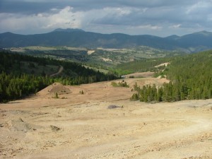
We got a fairly late start in Russell Gulch as we headed for Frontenac Mine. Dane was still in two-wheel drive as we headed up the icy hill, and he was rewarded with a fast, sideways slide back down to the bottom. We explored the mine a bit, and enjoyed the big views from the top. There was a lot of trash around and in the mine, which was disappointing.

We left the mine and headed down to the bottom so we could continue south. We figured we'd find a way to connect back with Oh-My-God Road in that direction. We explored quite a few spurs.

The first one went up to the top of a hill and circled around on itself. We were coming back down when we came face to face with a big truck on the narrow trail. They left some trash for us to pick up on our way down, then we never saw them again.

We explored another road that went by a house and some private driveways to private land. We went by the Santa Fe Shaft Mine and then the trail just dead ended at a fence. We turned around and headed back.

We took another spur that was partially hidden in the trees. We saw a hunter on the way by the Kokomo Shaft Mine who didn't seem too happy to see us. We kept following the trail as it got more and more faint, and then we decided that it was just too faint to keep following so we turned around. We took another way out, and that ended up looping back to the big crossroads again.

There was probably more to explore, but the light was fading so we wanted to get out of the network of confusing trails. We headed back for Frontenac Mine and went out a different way. We popped back out onto Oh-My-God Road just a bit south of Russell Gulch, then we headed back down to Idaho Springs.

We had a great dinner at Beau Jo's, wrapping up the 2006 season. It was a great year!

admiring_the_view
approaching_russell_gulch
bench
big_mine
dane_at_frontenac_mine
dane_describing_his_slide
dead_end
fading_trail
frontenac_mine_part_1
frontenac_mine_part_2
frontenac_mine_part_3
frontenac_mine_part_4
gary_at_frontenac_mine
into_the_snow
joey_exploring
little-used_trail
mellow_trail
old_structure
open_area
santa_fe_shaft_mine
snowy_mountains

Reports from Other Days: 2

Use the arrows or dots to flip through the previews of the other reports for Russell Gulch. Click one of them to read more and see all of the photos from that day.

June 2, 2007

Led by Monica I.
Most of us did Russell Gulch as a side trip on our way down Oh-My-God Road. We didn’t take too long exploring, but it was long enough to really enjoy the gorgeous scenery that the trail has to offer. We started on the Central City end, going directly to the…
»
  • 1
  • 2
Join Us!
If you aren’t a Member or Subscriber, you can’t see all of the content on this site. Get membership information to see why this site is best when you join and log in

Information for Subscribers

When you log in you’ll see more information here:

  • Recent Community Forum posts
  • Recent polls
  • Upcoming Events you can attend
  • Links to online users

© 2000-2021 · TrailDamage.com · Terms and Conditions · About · Contact
Trail information is only accurate on the date posted. Trails may have changed or closed since that date. Use this information for historical purposes only.
Contact the Forest Service or Bureau of Land Management for up-to-date trail information.

/* ----------------------------------------- */ /* View slug: reports-other-reports-for-same-trail-slider - start */ /* ----------------------------------------- */ /* place the prev/next controls on the sides */ .td-transition-controls .wpv-filter-next-link, .td-transition-controls .wpv-filter-previous-link { border: none; font-size: 300%; position: absolute; top: 70px; } .td-transition-controls .wpv-filter-previous-link { left: 0; } .td-transition-controls .wpv-filter-next-link { right: 0; } /* center the page selector horizonatally */ .td-transition-controls ul.wpv_pagination_dots { text-align: center; margin-top: 10px; } /* center the page selector horizonatally */ .td-transition-controls ul.wpv_pagination_dots li.wpv_pagination_dots_item, .td-transition-controls .wpv_pagination_dots li a { display: inline-block; float: none; } /* remove the default styles */ .td-transition-controls .wpv_pagination_dots li a { text-decoration: none; border-bottom: none; } .td-slider-container { padding: 0 25px; margin-bottom: 20px; position: relative; width:100%; display:table; } .td-slides { position: relative; } .td-slides-image { float:left; display:table-cell; } .td-slides-image img { border:1px solid #c0c0c0; } .td-slides-content { padding:4px 4px 4px 10px; border-top:1px solid #c0c0c0; border-right:1px solid #c0c0c0; border-bottom:1px solid #c0c0c0; display:table-cell; height:227px; overflow:hidden; } .td-slides-content h3 { margin-top:8px; } .td-slides-leader { font-size:smaller; margin-top:4px; } /* ----------------------------------------- */ /* View slug: reports-other-reports-for-same-trail-slider - end */ /* ----------------------------------------- */
/* ----------------------------------------- */ /* Content Template: Template for a Single Report - start */ /* ----------------------------------------- */ .entry-header { display:none; } .entry-content h1 { margin-top:16px; padding-top:0; } h1 a { color:#222; } h1 a:hover { color:#666; } p.entry-meta { font-size:small; } #report-body-spacer { clear:both; width:100%; height:20px; } #addtoany-bar { margin-bottom:2em; text-align:center; } .category-reports .post-info .author, .post-info .date { display: none; } .addthis_recommended_horizontal { text-align:center !important; } /* ----------------------------------------- */ /* Content Template: Template for a Single Report - end */ /* ----------------------------------------- */ /* ----------------------------------------- */ /* Content Template: Loop item in REPORTS Runners - start */ /* ----------------------------------------- */ #runners-container { width:100%; clear:both; } .runner { border:1px solid #c0c0c0; margin:0 6px 6px 0; float:left; width:49%; height:81px; } .runner-image { float: left; } .runner-image img { margin:2px 10px 0 2px; height:75px; width:75px; } .runner-name { text-transform:uppercase; } .runner-name a { color:#222; } .runner-name a:hover { color:#666; } .runner-vehicle { font-size:small; } @media only screen and (max-width: 768px) { .runner { width:100%; } } /* ----------------------------------------- */ /* Content Template: Loop item in REPORTS Runners - end */ /* ----------------------------------------- */