TrailDamage.com

Photos, videos and information about 4x4 trails in Colorado and Utah

  • Trails
    • Colorado
    • Utah
  • Reports
    • Featured Photos
    • Featured Videos
    • Reports Calendar
  • Members
  • Search
  • Trail Damage Winners
  • FAQ
  • Community
  • Upcoming Events
  • Membership
  • Log In
  • Facebook
  • Instagram
  • RSS
  • Twitter
  • YouTube

Pickle Gulch 091017

October 17, 2009 by Mike Shannon

Pickle Gulch

Trail Run on October 17, 2009
Report and photos by Mike S., Trail Leader
View trail information for Pickle Gulch

Cody H.
Black 1994 Toyota Pickup
Jeffrey M.
Khaki 2006 Jeep Wrangler Unlimited Rubicon
Walt S.
Gray 2022 Jeep Wrangler Unlimited Rubicon 392
Bill S.
Yellow 2020 Jeep Wrangler Rubicon
Ryan S.
Red 1999 Jeep Wrangler
Mike S.
Silver 2004 Jeep Wrangler Rubicon

Three trails down and one to go to finish out the day. It sounded easy enough, but it wasn't. Impressive as it was to drive right to the trailhead of Eldorado Mountain early in the morning, it was equally unimpressive watching us try to find the Pickle Gulch trailhead.

Sometimes it pays to read the TrailDamage.com trail reports for directions to the trails. We did not do that this time and it cost us about 45 minutes wandering around on Missouri Gulch Road looking for the trailhead. We had almost given up on finding Pickle Gulch. We finally headed back to the blacktop and there we found a sign to the Pickle Gulch group campground. We thought that we would give that a try, and guess what we found? We found the trailhead and we were finally working our way up the trail.

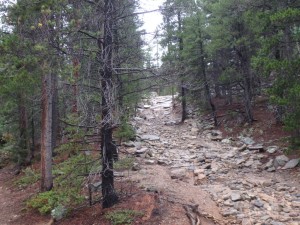
The trail started out going uphill in heavy trees, and it wasn't long before we reached the only obstacle. The trail split here with the rocky area to the right and an easier bypass to the left. Cody decided to take the bypass and everyone else tackled the obstacle. Unfortunately, we did not take pictures of the rocks or of any of us going over them. I think we were just too happy to be on the trail.

The trail merges back together again shortly after the obstacle. We continued on past a cabin that had seen better days. Walt tried to find the Snowden Mine but was having GPS issues and passed it before he knew it. We'll have to look for it next time. We seem to do this trail every six years so we'll be back in 2015.

The group wanted to finish the trail in daylight this time so we skipped all of the spurs. We would have to come back to explore the whole area. There was a great view to our left as we rode along a ridge before we came across the old camping trailer that had been there since 2003 when we were here last.

It wasn't very long before we were at the buildings with equipment that still looked like they were in use, yet somehow it seemed to be closed for quite some time. This was the end of the trail just above the town of Apex.

We did all four trails just like we planned and we had a great time doing it. A couple of us went out for Mexican food and the rest had plans to head for home. It was a fantastic day with good friends.

cabin
cool_trail
distant_road
group_on_the_trail_part_1
group_on_the_trail_part_2
old_trailer
see_for_miles
trailhead
unusual_shaped_mountain

Reports from Other Days: 3

Use the arrows or dots to flip through the previews of the other reports for Pickle Gulch. Click one of them to read more and see all of the photos from that day.

July 29, 2017

Led by Monica I.
We planned on camping for the entire weekend, but things came up and everyone canceled.  When we got to the meeting place in Black Hawk, we all agreed that it was a lucky break.  It was chilly and raining, and camping wouldn’t have been as much fun as it usually…
»
  • 1
  • 2
  • 3
Join Us!
If you aren’t a Member or Subscriber, you can’t see all of the content on this site. Get membership information to see why this site is best when you join and log in

Information for Subscribers

When you log in you’ll see more information here:

  • Recent Community Forum posts
  • Recent polls
  • Upcoming Events you can attend
  • Links to online users

© 2000-2023 · TrailDamage.com · Terms and Conditions · About · Contact
Trail information is only accurate on the date posted. Trails may have changed or closed since that date. Use this information for historical purposes only.
Contact the Forest Service or Bureau of Land Management for up-to-date trail information.

/* ----------------------------------------- */ /* View slug: reports-other-reports-for-same-trail-slider - start */ /* ----------------------------------------- */ /* place the prev/next controls on the sides */ .td-transition-controls .wpv-filter-next-link, .td-transition-controls .wpv-filter-previous-link { border: none; font-size: 300%; position: absolute; top: 70px; } .td-transition-controls .wpv-filter-previous-link { left: 0; } .td-transition-controls .wpv-filter-next-link { right: 0; } /* center the page selector horizonatally */ .td-transition-controls ul.wpv_pagination_dots { text-align: center; margin-top: 10px; } /* center the page selector horizonatally */ .td-transition-controls ul.wpv_pagination_dots li.wpv_pagination_dots_item, .td-transition-controls .wpv_pagination_dots li a { display: inline-block; float: none; } /* remove the default styles */ .td-transition-controls .wpv_pagination_dots li a { text-decoration: none; border-bottom: none; } .td-slider-container { padding: 0 25px; margin-bottom: 20px; position: relative; width:100%; display:table; } .td-slides { position: relative; } .td-slides-image { float:left; display:table-cell; } .td-slides-image img { border:1px solid #c0c0c0; } .td-slides-content { padding:4px 4px 4px 10px; border-top:1px solid #c0c0c0; border-right:1px solid #c0c0c0; border-bottom:1px solid #c0c0c0; display:table-cell; height:227px; overflow:hidden; } .td-slides-content h3 { margin-top:8px; } .td-slides-leader { font-size:smaller; margin-top:4px; } /* ----------------------------------------- */ /* View slug: reports-other-reports-for-same-trail-slider - end */ /* ----------------------------------------- */
/* ----------------------------------------- */ /* Content Template: Template for a Single Report - start */ /* ----------------------------------------- */ .entry-header { display:none; } .entry-content h1 { margin-top:16px; padding-top:0; } h1 a { color:#222; } h1 a:hover { color:#666; } p.entry-meta { font-size:small; } #report-body-spacer { clear:both; width:100%; height:20px; } #addtoany-bar { margin-bottom:2em; text-align:center; } .category-reports .post-info .author, .post-info .date { display: none; } .addthis_recommended_horizontal { text-align:center !important; } /* ----------------------------------------- */ /* Content Template: Template for a Single Report - end */ /* ----------------------------------------- */ /* ----------------------------------------- */ /* Content Template: Loop item in REPORTS Runners - start */ /* ----------------------------------------- */ #runners-container { width:100%; clear:both; } .runner { border:1px solid #c0c0c0; margin:0 6px 6px 0; float:left; width:49%; height:81px; } .runner-image { float: left; } .runner-image img { margin:2px 10px 0 2px; height:75px; width:75px; } .runner-name { text-transform:uppercase; } .runner-name a { color:#222; } .runner-name a:hover { color:#666; } .runner-vehicle { font-size:small; } @media only screen and (max-width: 768px) { .runner { width:100%; } } /* ----------------------------------------- */ /* Content Template: Loop item in REPORTS Runners - end */ /* ----------------------------------------- */