TrailDamage.com

Photos, videos and information about 4x4 trails in Colorado and Utah

  • Trails
    • Colorado
    • Utah
  • Reports
    • Featured Photos
    • Featured Videos
    • Reports Calendar
  • Members
  • Search
  • Trail Damage Winners
  • FAQ
  • Community
  • Upcoming Events
  • Membership
  • Log In
  • Facebook
  • Instagram
  • RSS
  • Twitter
  • YouTube

Phantom Canyon 080621

June 21, 2008 by Monica

Phantom Canyon

Trail Run on June 21, 2008
Report and photos by Monica I., Trail Leader
View trail information for Phantom Canyon

Mark U.
Red 1989 Jeep Wrangler
Don W.
Silver 2005 Jeep Wrangler Rubicon
Mike S.
Silver 2004 Jeep Wrangler Rubicon
Walt S.
Gray 2022 Jeep Wrangler Unlimited Rubicon 392
Roger R.
Gray 2021 Jeep Wrangler Rubicon 4xe
Brian D.
Brown 1978 International Scout II

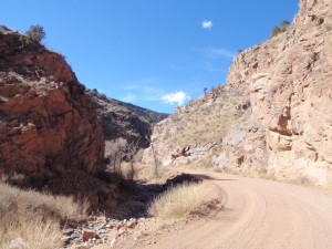
We finished up our day and our exploration of the Gold Belt Byway Tour by running Phantom Canyon from the south end back up to the north end at Victor. It was definitely more mellow and easy than Shelf Road was, but it had more scenery.

There were lots of trees and steep walls around us, with lots of people camping in available spaces. It was really pretty. We passed a nice rest area with a pit toilet, and then the cool scenery started. There were a few small bridges as we crossed over the creek a few times (though the creek bed was usually dry).

Then we passed through two tunnels. They were only wide enough to let one vehicle pass through, and we all imagined how cool the train trip must have been as it went through those tunnels and over those bridges. It really must have been an amazing ride.

One of the bridges stood out from the others because it was very high above the ground and it had guard rails that were painted red. There is even a parking area just south of it so you can get some good pictures and read the informational sign there. It was very pretty.

The northern half of the trail was pretty but uneventful. We stopped at the rest area on the other end (with pit toilets and parking) to put in windows and get ready for the drive home. It was starting to look like rain.

When we got started up again, Mark discovered that his Jeep was hot and didn't feel like running. He put a water bottle between his hood and the body of his Jeep and then used a bungee cord to hold the hood down. With the hood popped open just a bit like that, his Jeep stayed cool enough to continue right away.

At the far end, we discovered that a race in Victor was just finishing up, causing more detours. We aired up on a street in town, and got caught in a little rain. It was nice out, though, so no one really minded.

On the way home, everyone stopped in Woodland Park for a big dinner. It was a fabulous end to a fantastic day!

blue_sky
climbing
colorful
green_and_brown
lush
mark_overheating_part_1
mark_overheating_part_2
mark_overheating_part_3
mellow_trail
northern_tunnel
pavement_at_the_south_end
small_creek
south_end
southern_bridge
southern_rest_area
southern_tunnel_part_1
southern_tunnel_part_2
steep_walls
trail_sign
trail_through_rock
wooden_bridge_part_1
wooden_bridge_part_2
wooden_bridge_part_3

Reports from Other Days: 11

Use the arrows or dots to flip through the previews of the other reports for Phantom Canyon. Click one of them to read more and see all of the photos from that day.

February 19, 2012

Led by Matt K.
Phantom Canyon was our second and last trail run for the day. It’s an easy trail with bridges, old train tunnels and camping areas with rest stops. Though there were some spots along the trail with a bit of snow on them we didn’t have any issues along the way….
« »
  • 1
  • 2
  • 3
  • 4
  • 5
  • 6
  • 7
  • 8
  • 9
  • 10
  • 11
Join Us!
If you aren’t a Member or Subscriber, you can’t see all of the content on this site. Get membership information to see why this site is best when you join and log in

Information for Subscribers

When you log in you’ll see more information here:

  • Recent Community Forum posts
  • Recent polls
  • Upcoming Events you can attend
  • Links to online users

© 2000-2023 · TrailDamage.com · Terms and Conditions · About · Contact
Trail information is only accurate on the date posted. Trails may have changed or closed since that date. Use this information for historical purposes only.
Contact the Forest Service or Bureau of Land Management for up-to-date trail information.

/* ----------------------------------------- */ /* View slug: reports-other-reports-for-same-trail-slider - start */ /* ----------------------------------------- */ /* place the prev/next controls on the sides */ .td-transition-controls .wpv-filter-next-link, .td-transition-controls .wpv-filter-previous-link { border: none; font-size: 300%; position: absolute; top: 70px; } .td-transition-controls .wpv-filter-previous-link { left: 0; } .td-transition-controls .wpv-filter-next-link { right: 0; } /* center the page selector horizonatally */ .td-transition-controls ul.wpv_pagination_dots { text-align: center; margin-top: 10px; } /* center the page selector horizonatally */ .td-transition-controls ul.wpv_pagination_dots li.wpv_pagination_dots_item, .td-transition-controls .wpv_pagination_dots li a { display: inline-block; float: none; } /* remove the default styles */ .td-transition-controls .wpv_pagination_dots li a { text-decoration: none; border-bottom: none; } .td-slider-container { padding: 0 25px; margin-bottom: 20px; position: relative; width:100%; display:table; } .td-slides { position: relative; } .td-slides-image { float:left; display:table-cell; } .td-slides-image img { border:1px solid #c0c0c0; } .td-slides-content { padding:4px 4px 4px 10px; border-top:1px solid #c0c0c0; border-right:1px solid #c0c0c0; border-bottom:1px solid #c0c0c0; display:table-cell; height:227px; overflow:hidden; } .td-slides-content h3 { margin-top:8px; } .td-slides-leader { font-size:smaller; margin-top:4px; } /* ----------------------------------------- */ /* View slug: reports-other-reports-for-same-trail-slider - end */ /* ----------------------------------------- */
/* ----------------------------------------- */ /* Content Template: Template for a Single Report - start */ /* ----------------------------------------- */ .entry-header { display:none; } .entry-content h1 { margin-top:16px; padding-top:0; } h1 a { color:#222; } h1 a:hover { color:#666; } p.entry-meta { font-size:small; } #report-body-spacer { clear:both; width:100%; height:20px; } #addtoany-bar { margin-bottom:2em; text-align:center; } .category-reports .post-info .author, .post-info .date { display: none; } .addthis_recommended_horizontal { text-align:center !important; } /* ----------------------------------------- */ /* Content Template: Template for a Single Report - end */ /* ----------------------------------------- */ /* ----------------------------------------- */ /* Content Template: Loop item in REPORTS Runners - start */ /* ----------------------------------------- */ #runners-container { width:100%; clear:both; } .runner { border:1px solid #c0c0c0; margin:0 6px 6px 0; float:left; width:49%; height:81px; } .runner-image { float: left; } .runner-image img { margin:2px 10px 0 2px; height:75px; width:75px; } .runner-name { text-transform:uppercase; } .runner-name a { color:#222; } .runner-name a:hover { color:#666; } .runner-vehicle { font-size:small; } @media only screen and (max-width: 768px) { .runner { width:100%; } } /* ----------------------------------------- */ /* Content Template: Loop item in REPORTS Runners - end */ /* ----------------------------------------- */