TrailDamage.com

Photos, videos and information about 4x4 trails in Colorado and Utah

  • Trails
    • Colorado
    • Utah
  • Reports
    • Featured Photos
    • Featured Videos
    • Reports Calendar
  • Members
  • Search
  • Trail Damage Winners
  • FAQ
  • Community
  • Upcoming Events
  • Membership
  • Log In
  • Facebook
  • Instagram
  • RSS
  • Twitter
  • YouTube

Moonshine Arch 180514

May 14, 2018 by Monica

Moonshine Arch

Trail Run on May 14, 2018
Report and photos by Monica I., Trail Leader
View trail information for Moonshine Arch

Julie M.
Green 2012 Jeep Wrangler Unlimited Rubicon
Mike S.
Silver 2004 Jeep Wrangler Rubicon
Roger R.
Gray 2021 Jeep Wrangler Rubicon 4xe
Walt S.
Gray 2022 Jeep Wrangler Unlimited Rubicon 392
Monica I.
Red 2010 Jeep Wrangler Rubicon

We had intended to hike up to the arch because we didn't find any information until the day before that we could actually drive to it.  What a nice surprise!  We had been looking forward to the hike, but this would give us more time in the day for trails.  We almost missed the turn off (it's tough to spot) but we eventually all ended up off the pavement.

You can get to the harder trail a few different ways, but we managed to find the most-traveled way in.  We found a couple signs, and lots of evidence of other vehicles, bikes, and hikers in the sand.  The part past the fence and gate was pretty fun, but it kept getting better.

We did our first 360° video and we weren't sure how it would turn out.  It turned out well, so we'll do more of them.  They're longer and not for everyone, but it's a good way to see an entire trail (or just the good parts).

We were thinking things would be mellow until we came around a corner and saw the hill.  Monica happily announced the festivities on the CB and then everyone headed up.  It was a blast, and a great way to start the morning.  Slickrock is always best for breakfast.

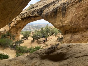
Unfortunately, it wasn't long before the fun trail was over and we were at the arch.  We parked all over the place, and had the whole area to ourselves while we were there.  Because we left first thing in the morning, we beat everyone to the site.  It ended up working out well.

We walked all over below and on top of the arch, just enjoying the place.  The view of the reservoir was even awesome from there.  As we left, we took turns parking under the arch for photos.

The way down was almost as fun, and we saw a few hikers making their way up.  It didn't take long for us to make it back to the trailhead, though.  We hadn't aired down, so we hopped back onto the pavement for the rest of our day near the Flaming Gorge.

P1000470
P1000471
P1000472
P1000473
P1000474
P1000475
P1000476
P1000477
P1000478
P1000479
P1000480
P1000481
P1000482
P1000485
P1000486
P1000487
P1000489
P1000490
P1000491
P1000492
P1000493
P1000494
P1000495
P1000496
P1000497
P1000498
P1000499
P1000500
P1000501
P1000502
P1000503
P1000504
P1000505
P1000506
P1000507
P1000508
P1000509
P1000510
P1000512
P1000513
P1000514
P1000515
P1000516
P1000517
P1000519
P1000521
P1000522
P1000523
P1000524
P1000525
P1000526
P1000527
P1000528
P1000531
P1000532
P1000533
P1000534
P1000536
P1000537
P1000539
P1000540
P1000541
P1000543
P1000544
P1000545
P1000546
P1000547
P1000548
P1000550
P1000551
P1000552

Report from a Different Day

July 13, 2021

Led by Matt K.
Moonshine Arch was the last trail for the day for Matt. The start of Moonshine Arch was really hard to find. There is a marker on the highway approaching it, but the little dirt road branching off looks more like a driveway than a road, so we missed it and…
Join Us!
If you aren’t a Member or Subscriber, you can’t see all of the content on this site. Get membership information to see why this site is best when you join and log in

Information for Subscribers

When you log in you’ll see more information here:

  • Recent Community Forum posts
  • Recent polls
  • Upcoming Events you can attend
  • Links to online users

© 2000-2022 · TrailDamage.com · Terms and Conditions · About · Contact
Trail information is only accurate on the date posted. Trails may have changed or closed since that date. Use this information for historical purposes only.
Contact the Forest Service or Bureau of Land Management for up-to-date trail information.

/* ----------------------------------------- */ /* View slug: reports-other-reports-for-same-trail-slider - start */ /* ----------------------------------------- */ /* place the prev/next controls on the sides */ .td-transition-controls .wpv-filter-next-link, .td-transition-controls .wpv-filter-previous-link { border: none; font-size: 300%; position: absolute; top: 70px; } .td-transition-controls .wpv-filter-previous-link { left: 0; } .td-transition-controls .wpv-filter-next-link { right: 0; } /* center the page selector horizonatally */ .td-transition-controls ul.wpv_pagination_dots { text-align: center; margin-top: 10px; } /* center the page selector horizonatally */ .td-transition-controls ul.wpv_pagination_dots li.wpv_pagination_dots_item, .td-transition-controls .wpv_pagination_dots li a { display: inline-block; float: none; } /* remove the default styles */ .td-transition-controls .wpv_pagination_dots li a { text-decoration: none; border-bottom: none; } .td-slider-container { padding: 0 25px; margin-bottom: 20px; position: relative; width:100%; display:table; } .td-slides { position: relative; } .td-slides-image { float:left; display:table-cell; } .td-slides-image img { border:1px solid #c0c0c0; } .td-slides-content { padding:4px 4px 4px 10px; border-top:1px solid #c0c0c0; border-right:1px solid #c0c0c0; border-bottom:1px solid #c0c0c0; display:table-cell; height:227px; overflow:hidden; } .td-slides-content h3 { margin-top:8px; } .td-slides-leader { font-size:smaller; margin-top:4px; } /* ----------------------------------------- */ /* View slug: reports-other-reports-for-same-trail-slider - end */ /* ----------------------------------------- */
/* ----------------------------------------- */ /* Content Template: Template for a Single Report - start */ /* ----------------------------------------- */ .entry-header { display:none; } .entry-content h1 { margin-top:16px; padding-top:0; } h1 a { color:#222; } h1 a:hover { color:#666; } p.entry-meta { font-size:small; } #report-body-spacer { clear:both; width:100%; height:20px; } #addtoany-bar { margin-bottom:2em; text-align:center; } .category-reports .post-info .author, .post-info .date { display: none; } .addthis_recommended_horizontal { text-align:center !important; } /* ----------------------------------------- */ /* Content Template: Template for a Single Report - end */ /* ----------------------------------------- */ /* ----------------------------------------- */ /* Content Template: Loop item in REPORTS Runners - start */ /* ----------------------------------------- */ #runners-container { width:100%; clear:both; } .runner { border:1px solid #c0c0c0; margin:0 6px 6px 0; float:left; width:49%; height:81px; } .runner-image { float: left; } .runner-image img { margin:2px 10px 0 2px; height:75px; width:75px; } .runner-name { text-transform:uppercase; } .runner-name a { color:#222; } .runner-name a:hover { color:#666; } .runner-vehicle { font-size:small; } @media only screen and (max-width: 768px) { .runner { width:100%; } } /* ----------------------------------------- */ /* Content Template: Loop item in REPORTS Runners - end */ /* ----------------------------------------- */