TrailDamage.com

Photos, videos and information about 4x4 trails in Colorado and Utah

  • Trails
    • Colorado
    • Utah
  • Reports
    • Featured Photos
    • Featured Videos
    • Reports Calendar
  • Members
  • Search
  • Trail Damage Winners
  • FAQ
  • Community
  • Upcoming Events
  • Membership
  • Log In
  • Facebook
  • Instagram
  • RSS
  • Twitter
  • YouTube

Hermit Pass 060818

August 18, 2006 by Monica

Hermit Pass

Trail Run on August 18, 2006
Report and photos by Monica I., Trail Leader
View trail information for Hermit Pass

Don W.
Silver 2005 Jeep Wrangler Rubicon
Gary R.
Yellow 1978 Jeep CJ-7
Monica I.
Red 2010 Jeep Wrangler Rubicon
Bill S.
Yellow 2020 Jeep Wrangler Rubicon
Bob R.
Green 2003 Jeep Wrangler Rubicon

Hermit Pass is one of the most beautiful trails in Colorado, and it's a fairly mellow drive all the way over 13,000 feet. That's why we made sure we got to see it on our way down to Alamosa.

It was supposed to rain, so we were prepared. When we started out, though, it was really nice. It wasn't hot and it wasn't raining. It was perfect weather for wheeling.

There weren't too many people on the trail as we worked our way up. Don heard a noise coming from his Jeep and couldn't figure out what it was, but eventually he found his trackbar bolt was really loose. He tightened it up and he was good to go.

We had lunch soon after starting up the trail. We found a nice, wide, flat area where we set up and had a great lunch. We were so relaxed we weren't in much of a hurry to get going again.

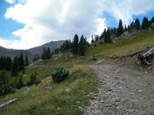
We worked our way up to timberline, then passed the trees and up to the lakes. It was beautiful. We looked back and it was pouring rain on Westcliffe and our trailhead, but we were still in perfect weather.

It was cold and windy at the top, but that was to be expected. We walked out to the edge to check out Horseshoe Lake and the views back toward Westcliffe where it was still raining. We put in windows and got ready to drive down into the rain.

While we were at the top, the clouds really started rolling in. We were surrounded by clouds and it was still so gorgeous!

We drove down and out of the clouds and found that the rain had ended and the trail was just a little bit wet from the earlier rain. We didn't have any issues on the way down, though Gary was hearing a weird noise. He found out that his front fender was really coming off -- probably some damage he got on 21 Road the month before.

We got down to Westcliffe and we managed to make it through the trail without actually getting rained on. We aired up and went south to find a new trail and a new way to Alamosa.

airing_down
at_the_top_part_1
at_the_top_part_2
big_valley
bill_above_horseshoe_lake
bill_on_the_trail
bob_and_don
climbing_above_timberline
climbing
don_above_horseshoe_lake
don_and_bill
don_heard_something
don_near_the_top
don_on_the_edge
don_on_the_trail
down_to_westcliffe
early_mountain_view
early_trail
eureka_mountain
gary_heard_a_noise
gary_on_the_trail
gary_trail_damage
getting_narrow
hermit_lake
hiding_marmot
horseshoe_lake_part_1
horseshoe_lake_part_2
horseshoe_lake_part_3
horseshoe_lake_part_4
layers_of_mountains
lunch
many_colors
mellow_trail
middle_taylor_creek
no_trees
other_side_of_hermit_pass
past_horseshoe_lake
rocky_mountain
start_of_the_switchbacks
switchback
the_way_we_came
trail_above_horseshoe_lake_part_1
trail_above_horseshoe_lake_part_2
trail_closed
trail_on_the_edge
view_of_the_other_side
westcliffe
wizard_of_oz_trees

Reports from Other Days: 2

Use the arrows or dots to flip through the previews of the other reports for Hermit Pass. Click one of them to read more and see all of the photos from that day.

August 26, 2011

Led by Monica I.
What would a trip to Alamosa be without Hermit Pass on the way? It’s one of our favorites so we had to visit it again. We had a nice trip to Westcliffe where we found a gas station and a big lot where Mark could leave his truck and trailer….
»
  • 1
  • 2
Join Us!
If you aren’t a Member or Subscriber, you can’t see all of the content on this site. Get membership information to see why this site is best when you join and log in

Information for Subscribers

When you log in you’ll see more information here:

  • Recent Community Forum posts
  • Recent polls
  • Upcoming Events you can attend
  • Links to online users

© 2000-2022 · TrailDamage.com · Terms and Conditions · About · Contact
Trail information is only accurate on the date posted. Trails may have changed or closed since that date. Use this information for historical purposes only.
Contact the Forest Service or Bureau of Land Management for up-to-date trail information.

/* ----------------------------------------- */ /* View slug: reports-other-reports-for-same-trail-slider - start */ /* ----------------------------------------- */ /* place the prev/next controls on the sides */ .td-transition-controls .wpv-filter-next-link, .td-transition-controls .wpv-filter-previous-link { border: none; font-size: 300%; position: absolute; top: 70px; } .td-transition-controls .wpv-filter-previous-link { left: 0; } .td-transition-controls .wpv-filter-next-link { right: 0; } /* center the page selector horizonatally */ .td-transition-controls ul.wpv_pagination_dots { text-align: center; margin-top: 10px; } /* center the page selector horizonatally */ .td-transition-controls ul.wpv_pagination_dots li.wpv_pagination_dots_item, .td-transition-controls .wpv_pagination_dots li a { display: inline-block; float: none; } /* remove the default styles */ .td-transition-controls .wpv_pagination_dots li a { text-decoration: none; border-bottom: none; } .td-slider-container { padding: 0 25px; margin-bottom: 20px; position: relative; width:100%; display:table; } .td-slides { position: relative; } .td-slides-image { float:left; display:table-cell; } .td-slides-image img { border:1px solid #c0c0c0; } .td-slides-content { padding:4px 4px 4px 10px; border-top:1px solid #c0c0c0; border-right:1px solid #c0c0c0; border-bottom:1px solid #c0c0c0; display:table-cell; height:227px; overflow:hidden; } .td-slides-content h3 { margin-top:8px; } .td-slides-leader { font-size:smaller; margin-top:4px; } /* ----------------------------------------- */ /* View slug: reports-other-reports-for-same-trail-slider - end */ /* ----------------------------------------- */
/* ----------------------------------------- */ /* Content Template: Template for a Single Report - start */ /* ----------------------------------------- */ .entry-header { display:none; } .entry-content h1 { margin-top:16px; padding-top:0; } h1 a { color:#222; } h1 a:hover { color:#666; } p.entry-meta { font-size:small; } #report-body-spacer { clear:both; width:100%; height:20px; } #addtoany-bar { margin-bottom:2em; text-align:center; } .category-reports .post-info .author, .post-info .date { display: none; } .addthis_recommended_horizontal { text-align:center !important; } /* ----------------------------------------- */ /* Content Template: Template for a Single Report - end */ /* ----------------------------------------- */ /* ----------------------------------------- */ /* Content Template: Loop item in REPORTS Runners - start */ /* ----------------------------------------- */ #runners-container { width:100%; clear:both; } .runner { border:1px solid #c0c0c0; margin:0 6px 6px 0; float:left; width:49%; height:81px; } .runner-image { float: left; } .runner-image img { margin:2px 10px 0 2px; height:75px; width:75px; } .runner-name { text-transform:uppercase; } .runner-name a { color:#222; } .runner-name a:hover { color:#666; } .runner-vehicle { font-size:small; } @media only screen and (max-width: 768px) { .runner { width:100%; } } /* ----------------------------------------- */ /* Content Template: Loop item in REPORTS Runners - end */ /* ----------------------------------------- */