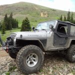
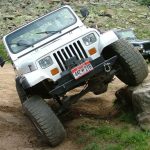
TrailDamage.com

Photos, videos and information about 4x4 trails in Colorado and Utah

  • Trails
    • Colorado
    • Utah
  • Reports
    • Featured Photos
    • Featured Videos
    • Reports Calendar
  • Members
  • Search
  • Trail Damage Winners
  • FAQ
  • Community
  • Upcoming Events
  • Membership
  • Log In
  • Facebook
  • Instagram
  • RSS
  • Twitter
  • YouTube

Georgia Pass 140726

July 26, 2014 by Monica

Georgia Pass

Trail Run on July 26, 2014
Report and photos by Monica I., Trail Leader
View trail information for Georgia Pass

Gary R.
Yellow 1978 Jeep CJ-7
Monica I.
Red 2010 Jeep Wrangler Rubicon
Paula S.
Silver 2000 Jeep Wrangler
Matt K.
White 2016 Jeep Wrangler Unlimited Rubicon
Julie M.
Green 2012 Jeep Wrangler Unlimited Rubicon
Austin C.
Khaki 2004 Jeep Wrangler Unlimited Rubicon
Walt S.
Gray 2022 Jeep Wrangler Unlimited Rubicon 392

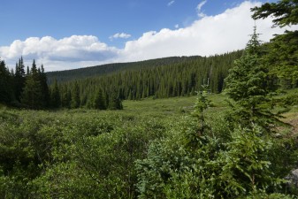
We had a big day planned, and we'd spend a large part of it above timberline near the Continental Divide. It had been raining nearly every afternoon in Denver, and we hoped to escape it while we were in the high country. We planned on finishing with S.O.B. Hill and we knew that rain could make that difficult to impossible. We aired down in Jefferson and headed up to the pass.

The trip on the southern end is usually fairly uneventful, and this time was no exception. It didn't take us long to get to the pass, where we found a couple groups of people far off of the trail on the tundra above timberline. They were too far to talk to, so all we could do is watch. Stay on the trail, people!

Part of our trip was to check out Glacier Ridge, because we heard it was closed. With fingers crossed, we went to the trailhead for that trail and found it blocked by a long fence. It was such a great 4x4 trail, so we were pretty bummed. It would be a good but steep hiking trail for others, now.

We went back to the pass and headed down the other side. This side is always a lot more fun. It was rocky and twisted in many places, and we enjoyed it. We saw a few more people abusing the trail a bit, and then we stopped for a break near a hiking trail in the parking area there. The recent rains brought the mosquitoes out in full force, so we didn't hang out for long.

There were a few fun water crossings over the South Fork of the Swan River, and then we got to Moe Cabin. We found a smoking campfire, trash everywhere, and no one in sight. It was very sad to see. We stopped to put out the fire completely and then started cleaning. There was a lot of broken glass and evidence of a party, and we filled up our Jeeps with garbage. It took a while, but we left it as nice as we could.

It didn't take long to get to the northern end. The clouds looked menacing so we put tops back up and windows on. It started hailing as we were finishing up with that, so the timing was good. Other than the idiots and evidence of idiots, Georgia Pass was a nice trail. We kept going to head up the Swan River trail.

airing_down
austin_downhill
bog
bumpy
creek_crossing
curve
descent
easy_trail
flowers_in_july
forest_service_sign
gary_downhill
georgia_pass_sign
glacier_ridge
great_flume_hiking_trail
healthy_forest
julie_on_the_trail
log
lush_greens
matt_downhill
matt_in_trees
matt_on_the_trail
michigan_creek_campground_sign
michigan_creek_campground
moe_cabin
morning_shadows
mount_guyot_in_the_distance
mountain_view
muddy
paula_downhill
purple_flowers
rocks
south_park
southern_start
switchback
walt_downhill
wavy
wrecked_cabin
yellow_flowers

Reports from Other Days: 4

Use the arrows or dots to flip through the previews of the other reports for Georgia Pass. Click one of them to read more and see all of the photos from that day.

August 1, 2020

Led by Monica I.
Though it had been raining really hard, it suddenly cleared up.  We only chatted for a few seconds before deciding to take Georgia Pass back over to Highway 285 rather than taking I-70 home.  So we headed over to the trailhead and up the trail. It was always a long,…
»
  • 1
  • 2
  • 3
  • 4
Join Us!
If you aren’t a Member or Subscriber, you can’t see all of the content on this site. Get membership information to see why this site is best when you join and log in

Information for Subscribers

When you log in you’ll see more information here:

  • Recent Community Forum posts
  • Recent polls
  • Upcoming Events you can attend
  • Links to online users

© 2000-2023 · TrailDamage.com · Terms and Conditions · About · Contact
Trail information is only accurate on the date posted. Trails may have changed or closed since that date. Use this information for historical purposes only.
Contact the Forest Service or Bureau of Land Management for up-to-date trail information.

/* ----------------------------------------- */ /* View slug: reports-other-reports-for-same-trail-slider - start */ /* ----------------------------------------- */ /* place the prev/next controls on the sides */ .td-transition-controls .wpv-filter-next-link, .td-transition-controls .wpv-filter-previous-link { border: none; font-size: 300%; position: absolute; top: 70px; } .td-transition-controls .wpv-filter-previous-link { left: 0; } .td-transition-controls .wpv-filter-next-link { right: 0; } /* center the page selector horizonatally */ .td-transition-controls ul.wpv_pagination_dots { text-align: center; margin-top: 10px; } /* center the page selector horizonatally */ .td-transition-controls ul.wpv_pagination_dots li.wpv_pagination_dots_item, .td-transition-controls .wpv_pagination_dots li a { display: inline-block; float: none; } /* remove the default styles */ .td-transition-controls .wpv_pagination_dots li a { text-decoration: none; border-bottom: none; } .td-slider-container { padding: 0 25px; margin-bottom: 20px; position: relative; width:100%; display:table; } .td-slides { position: relative; } .td-slides-image { float:left; display:table-cell; } .td-slides-image img { border:1px solid #c0c0c0; } .td-slides-content { padding:4px 4px 4px 10px; border-top:1px solid #c0c0c0; border-right:1px solid #c0c0c0; border-bottom:1px solid #c0c0c0; display:table-cell; height:227px; overflow:hidden; } .td-slides-content h3 { margin-top:8px; } .td-slides-leader { font-size:smaller; margin-top:4px; } /* ----------------------------------------- */ /* View slug: reports-other-reports-for-same-trail-slider - end */ /* ----------------------------------------- */
/* ----------------------------------------- */ /* Content Template: Template for a Single Report - start */ /* ----------------------------------------- */ .entry-header { display:none; } .entry-content h1 { margin-top:16px; padding-top:0; } h1 a { color:#222; } h1 a:hover { color:#666; } p.entry-meta { font-size:small; } #report-body-spacer { clear:both; width:100%; height:20px; } #addtoany-bar { margin-bottom:2em; text-align:center; } .category-reports .post-info .author, .post-info .date { display: none; } .addthis_recommended_horizontal { text-align:center !important; } /* ----------------------------------------- */ /* Content Template: Template for a Single Report - end */ /* ----------------------------------------- */ /* ----------------------------------------- */ /* Content Template: Loop item in REPORTS Runners - start */ /* ----------------------------------------- */ #runners-container { width:100%; clear:both; } .runner { border:1px solid #c0c0c0; margin:0 6px 6px 0; float:left; width:49%; height:81px; } .runner-image { float: left; } .runner-image img { margin:2px 10px 0 2px; height:75px; width:75px; } .runner-name { text-transform:uppercase; } .runner-name a { color:#222; } .runner-name a:hover { color:#666; } .runner-vehicle { font-size:small; } @media only screen and (max-width: 768px) { .runner { width:100%; } } /* ----------------------------------------- */ /* Content Template: Loop item in REPORTS Runners - end */ /* ----------------------------------------- */