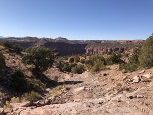
TrailDamage.com

Photos, videos and information about 4x4 trails in Colorado and Utah

  • Trails
    • Colorado
    • Utah
  • Reports
    • Featured Photos
    • Featured Videos
    • Reports Calendar
  • Members
  • Search
  • Trail Damage Winners
  • FAQ
  • Community
  • Upcoming Events
  • Membership
  • Log In
  • Facebook
  • Instagram
  • RSS
  • Twitter
  • YouTube

Flat Iron Mesa 070323

March 23, 2007 by Mike Shannon

Flat Iron Mesa

Trail Run on March 23, 2007
Report and photos by Mike S., Trail Leader
View trail information for Flat Iron Mesa

Mike S.
Silver 2004 Jeep Wrangler Rubicon
Roger R.
Gray 2021 Jeep Wrangler Rubicon 4xe
Brad R.
Yellow 2005 Jeep Wrangler

We were ready to tackle Flat Iron Mesa early in the day, expecting a long time on this trail. Armed with the GPS, printed-out topo maps with the route marked, and previous descriptions of the trail, we still had a little difficulty finding the start of the trail. Once we realized there was a gate directly behind us after we turned off the highway, we were on our way.

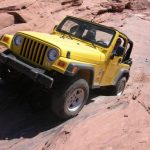
Rubble Hill was fun, but even the rental Jeep made it up easily. It appears that the other side might be more fun to come up, but we wanted to press on so we didn't try it. The dome and ledges were great fun and we really got a taste of what Brad and the rental Jeep could do (we'd really see him test its limits on Fins & Things later in the day).

We made it to Tilt-a-Whirl, and Mike and Roger went down with no issues. Brad took the bypass this time. It looked like he could make it, but perhaps not without damage to the skid plates or bumpers. The papers in the Jeep included a price sheet for each of these items if they were returned damaged! Brad did go down the optional ledges just after Tilt-a-Whirl without any issues, though.

We got to Easter Egg Hill, and after watching Mike go through and kiss the rock on the right with his flare, Roger and Brad opted to go around. Mike went on through the Squeeze, wishing he had a spotter. He soon met up with the other guys after the bypass reconnected with the trail.

Someone has built a home and fenced off the last part of the described trail out to the county road, so a small detour had to be made to a parallel trail. We were soon out on the county road, however, and wondering if more development is going to encroach on this trail. We hope not, because this is one we really want to run again.

brad_down_a_ledge_part_1
brad_down_a_ledge_part_2
brad_down_slickrock
brad_over_an_obstacle
brad_up_rubble_hill
brad_up_slickrock_part_1
brad_up_slickrock_part_2
brad_up_slickrock_part_3
brad_up_slickrock_part_4
brad_up_slickrock_part_5
brad_up_the_first_obstacle
hatch_wash_part_1
hatch_wash_part_2
mike_down_easter_egg_hill_part_1
mike_down_easter_egg_hill_part_2
mike_down_easter_egg_hill_part_3
mike_down_easter_egg_hill_part_4
mike_down_tilt-a-whirl_part_1
mike_down_tilt-a-whirl_part_2
mike_down_tilt-a-whirl_part_3
mike_down_tilt-a-whirl_part_4
mike_up_rubble_hill
mike_up_slickrock_part_1
mike_up_slickrock_part_2
mike_up_slickrock_part_3
mike_up_the_first_obstacle
roger_and_brad_at_rubble_hill
roger_down_a_ledge
roger_down_slickrock
roger_down_tilt-a-whirl_part_1
roger_down_tilt-a-whirl_part_2
roger_down_tilt-a-whirl_part_3
roger_down_tilt-a-whirl_part_4
roger_over_an_obstacle_part_1
roger_over_an_obstacle_part_2
roger_up_rubble_hill
roger_up_slickrock_part_1
roger_up_slickrock_part_2
roger_up_slickrock_part_3
roger_up_the_first_obstacle

Reports from Other Days: 5

Use the arrows or dots to flip through the previews of the other reports for Flat Iron Mesa. Click one of them to read more and see all of the photos from that day.

October 19, 2019

Led by Matt K.
Flat Iron Mesa was our first trail for Moab in the Fall of 2019. Matt had been wanting to run Flat Iron Mesa for some time, and now his time had finally come! We started at the north end of Flat Iron Mesa and aired down in the parking area…
»
  • 1
  • 2
  • 3
  • 4
  • 5
Join Us!
If you aren’t a Member or Subscriber, you can’t see all of the content on this site. Get membership information to see why this site is best when you join and log in

Information for Subscribers

When you log in you’ll see more information here:

  • Recent Community Forum posts
  • Recent polls
  • Upcoming Events you can attend
  • Links to online users

© 2000-2022 · TrailDamage.com · Terms and Conditions · About · Contact
Trail information is only accurate on the date posted. Trails may have changed or closed since that date. Use this information for historical purposes only.
Contact the Forest Service or Bureau of Land Management for up-to-date trail information.

/* ----------------------------------------- */ /* View slug: reports-other-reports-for-same-trail-slider - start */ /* ----------------------------------------- */ /* place the prev/next controls on the sides */ .td-transition-controls .wpv-filter-next-link, .td-transition-controls .wpv-filter-previous-link { border: none; font-size: 300%; position: absolute; top: 70px; } .td-transition-controls .wpv-filter-previous-link { left: 0; } .td-transition-controls .wpv-filter-next-link { right: 0; } /* center the page selector horizonatally */ .td-transition-controls ul.wpv_pagination_dots { text-align: center; margin-top: 10px; } /* center the page selector horizonatally */ .td-transition-controls ul.wpv_pagination_dots li.wpv_pagination_dots_item, .td-transition-controls .wpv_pagination_dots li a { display: inline-block; float: none; } /* remove the default styles */ .td-transition-controls .wpv_pagination_dots li a { text-decoration: none; border-bottom: none; } .td-slider-container { padding: 0 25px; margin-bottom: 20px; position: relative; width:100%; display:table; } .td-slides { position: relative; } .td-slides-image { float:left; display:table-cell; } .td-slides-image img { border:1px solid #c0c0c0; } .td-slides-content { padding:4px 4px 4px 10px; border-top:1px solid #c0c0c0; border-right:1px solid #c0c0c0; border-bottom:1px solid #c0c0c0; display:table-cell; height:227px; overflow:hidden; } .td-slides-content h3 { margin-top:8px; } .td-slides-leader { font-size:smaller; margin-top:4px; } /* ----------------------------------------- */ /* View slug: reports-other-reports-for-same-trail-slider - end */ /* ----------------------------------------- */
/* ----------------------------------------- */ /* Content Template: Template for a Single Report - start */ /* ----------------------------------------- */ .entry-header { display:none; } .entry-content h1 { margin-top:16px; padding-top:0; } h1 a { color:#222; } h1 a:hover { color:#666; } p.entry-meta { font-size:small; } #report-body-spacer { clear:both; width:100%; height:20px; } #addtoany-bar { margin-bottom:2em; text-align:center; } .category-reports .post-info .author, .post-info .date { display: none; } .addthis_recommended_horizontal { text-align:center !important; } /* ----------------------------------------- */ /* Content Template: Template for a Single Report - end */ /* ----------------------------------------- */ /* ----------------------------------------- */ /* Content Template: Loop item in REPORTS Runners - start */ /* ----------------------------------------- */ #runners-container { width:100%; clear:both; } .runner { border:1px solid #c0c0c0; margin:0 6px 6px 0; float:left; width:49%; height:81px; } .runner-image { float: left; } .runner-image img { margin:2px 10px 0 2px; height:75px; width:75px; } .runner-name { text-transform:uppercase; } .runner-name a { color:#222; } .runner-name a:hover { color:#666; } .runner-vehicle { font-size:small; } @media only screen and (max-width: 768px) { .runner { width:100%; } } /* ----------------------------------------- */ /* Content Template: Loop item in REPORTS Runners - end */ /* ----------------------------------------- */