TrailDamage.com

Photos, videos and information about 4x4 trails in Colorado and Utah

  • Trails
    • Colorado
    • Utah
  • Reports
    • Featured Photos
    • Featured Videos
    • Reports Calendar
  • Members
  • Search
  • Trail Damage Winners
  • FAQ
  • Community
  • Upcoming Events
  • Membership
  • Log In
  • Facebook
  • Instagram
  • RSS
  • Twitter
  • YouTube

Fireman Hill 110618

June 18, 2011 by Monica

Fireman Hill

Trail Run on June 18, 2011
Report and photos by Monica I., Trail Leader
View trail information for Fireman Hill

Gary R.
Yellow 1978 Jeep CJ-7
Walt S.
Gray 2022 Jeep Wrangler Unlimited Rubicon 392
Mark U.
Red 1989 Jeep Wrangler
Katie L.
Blue 2004 Nissan Xterra
Matt K.
White 2016 Jeep Wrangler Unlimited Rubicon
Mark C.
Green 1993 Jeep Cherokee
Bill S.
Yellow 2020 Jeep Wrangler Rubicon
Monica I.
Red 2010 Jeep Wrangler Rubicon
Jim D.
Silver 2003 Jeep Wrangler
Chris B.
Blue 2004 Jeep Wrangler Unlimited

We had just finished Castle Gulch and we were back at the Upper Kiosk. We planned on finishing the trail network by running Fireman Hill downhill. We had heard of some changes but we didn't know what the trail looked like now.

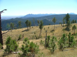
We headed for the overlook, skipping the overlook bypass this time. There was plenty of room to park at the overlook this time, which was nice. We hung out for a bit, enjoying the views and the nice weather. It was sad to see the burn area on the next hill over. You could really see for a long distance into the front range. We could even see DIA from up there.

After leaving the overlook and coming back to the main trail we came to the part where they had started to map out the new trail with posts and cable. When Carnage Canyon was closed they started working on a new, challenging trail to replace it. Work has stalled, though, and the trail is not finished or available to motor vehicles.

The future trail seems to loop away from the Fireman Hill trail and then come back to it. The loops are small but some appear to be challenging with big rocks. Only time will tell if the effort was worth it, if it opens at all.

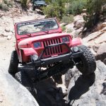
We relaxed there for a little bit and then headed downhill. The rocks were just as fun as ever. We were surprised to see a legal bypass around a rocky section marked with a forest service sign and the word "bypass" because those aren't usually marked. It wasn't much of a bypass and it didn't avoid all of the rocks, so there really isn't much of a point to it. No one needed the bypass.

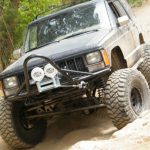
Once we got to the bottom of the hill the trail was easy as we went through a series of switchbacks that took us to Five Points. Endo Hill was completely gone and overgrown. It was a dangerous obstacle so it won't be missed much by us, but it was sad to see the option gone. Posts and cable make only one path down to the bottom of the hill.

After Fireman Hill we did a bit more of Left Hand Canyon and headed out. Though some of us did a bit of Nugget Hill we didn't finish it, but that was all right. A few burgers in Boulder hit the spot and it was a great day. It should be a great season!

at_the_overlook
bottom_of_the_rocky_hill
bypass_sign
cloudy
down_from_the_overlook
down_the_rocks
gary_on_the_trail_part_2
gary_on_the_trail
group_shot
hanging_out
jim_and_mark_c
jim_on_the_trail
lean-to
matt_on_the_trail
mellow_section
monica_on_the_trail
overlook_part_1
overlook_part_2
overlook_part_3
overlook_part_4
overlook_part_5
overlook_part_6
short_trees
toward_the_rocks
walking_the_future_trail_part_1
walking_the_future_trail_part_2
walking_the_future_trail_part_3
walking_the_future_trail_part_4
walking_the_future_trail_part_5
walking_the_future_trail_part_6
walt_on_the_trail
working_our_way_down

Reports from Other Days: 2

Use the arrows or dots to flip through the previews of the other reports for Fireman Hill. Click one of them to read more and see all of the photos from that day.

September 30, 2007

Led by Monica I.
We finished our lunch at the upper kiosk and started down Fireman Hill. We wanted to make sure we avoided the tough and dangerous way down Endo Hill, but otherwise we wanted to see everything. When we got to the intersection with the overlook trail we took it. It wasn’t…
»
  • 1
  • 2
Join Us!
If you aren’t a Member or Subscriber, you can’t see all of the content on this site. Get membership information to see why this site is best when you join and log in

Information for Subscribers

When you log in you’ll see more information here:

  • Recent Community Forum posts
  • Recent polls
  • Upcoming Events you can attend
  • Links to online users

© 2000-2023 · TrailDamage.com · Terms and Conditions · About · Contact
Trail information is only accurate on the date posted. Trails may have changed or closed since that date. Use this information for historical purposes only.
Contact the Forest Service or Bureau of Land Management for up-to-date trail information.

/* ----------------------------------------- */ /* View slug: reports-other-reports-for-same-trail-slider - start */ /* ----------------------------------------- */ /* place the prev/next controls on the sides */ .td-transition-controls .wpv-filter-next-link, .td-transition-controls .wpv-filter-previous-link { border: none; font-size: 300%; position: absolute; top: 70px; } .td-transition-controls .wpv-filter-previous-link { left: 0; } .td-transition-controls .wpv-filter-next-link { right: 0; } /* center the page selector horizonatally */ .td-transition-controls ul.wpv_pagination_dots { text-align: center; margin-top: 10px; } /* center the page selector horizonatally */ .td-transition-controls ul.wpv_pagination_dots li.wpv_pagination_dots_item, .td-transition-controls .wpv_pagination_dots li a { display: inline-block; float: none; } /* remove the default styles */ .td-transition-controls .wpv_pagination_dots li a { text-decoration: none; border-bottom: none; } .td-slider-container { padding: 0 25px; margin-bottom: 20px; position: relative; width:100%; display:table; } .td-slides { position: relative; } .td-slides-image { float:left; display:table-cell; } .td-slides-image img { border:1px solid #c0c0c0; } .td-slides-content { padding:4px 4px 4px 10px; border-top:1px solid #c0c0c0; border-right:1px solid #c0c0c0; border-bottom:1px solid #c0c0c0; display:table-cell; height:227px; overflow:hidden; } .td-slides-content h3 { margin-top:8px; } .td-slides-leader { font-size:smaller; margin-top:4px; } /* ----------------------------------------- */ /* View slug: reports-other-reports-for-same-trail-slider - end */ /* ----------------------------------------- */
/* ----------------------------------------- */ /* Content Template: Template for a Single Report - start */ /* ----------------------------------------- */ .entry-header { display:none; } .entry-content h1 { margin-top:16px; padding-top:0; } h1 a { color:#222; } h1 a:hover { color:#666; } p.entry-meta { font-size:small; } #report-body-spacer { clear:both; width:100%; height:20px; } #addtoany-bar { margin-bottom:2em; text-align:center; } .category-reports .post-info .author, .post-info .date { display: none; } .addthis_recommended_horizontal { text-align:center !important; } /* ----------------------------------------- */ /* Content Template: Template for a Single Report - end */ /* ----------------------------------------- */ /* ----------------------------------------- */ /* Content Template: Loop item in REPORTS Runners - start */ /* ----------------------------------------- */ #runners-container { width:100%; clear:both; } .runner { border:1px solid #c0c0c0; margin:0 6px 6px 0; float:left; width:49%; height:81px; } .runner-image { float: left; } .runner-image img { margin:2px 10px 0 2px; height:75px; width:75px; } .runner-name { text-transform:uppercase; } .runner-name a { color:#222; } .runner-name a:hover { color:#666; } .runner-vehicle { font-size:small; } @media only screen and (max-width: 768px) { .runner { width:100%; } } /* ----------------------------------------- */ /* Content Template: Loop item in REPORTS Runners - end */ /* ----------------------------------------- */