TrailDamage.com

Photos, videos and information about 4x4 trails in Colorado and Utah

  • Trails
    • Colorado
    • Utah
  • Reports
    • Featured Photos
    • Featured Videos
    • Reports Calendar
  • Members
  • Search
  • Trail Damage Winners
  • FAQ
  • Community
  • Upcoming Events
  • Membership
  • Log In
  • Facebook
  • Instagram
  • RSS
  • Twitter
  • YouTube

Dolores River 120520

May 20, 2012 by Monica

Dolores River

Trail Run on May 20, 2012
Report and photos by Monica I., Trail Leader
View trail information for Dolores River

Monica I.
Red 2010 Jeep Wrangler Rubicon
Mike S.
Silver 2004 Jeep Wrangler Rubicon
Julie M.
Green 2012 Jeep Wrangler Unlimited Rubicon
Walt S.
Gold 2004 Jeep Wrangler Rubicon

We were heading for home with dirty Jeeps and mild sunburns. We had a long day planned, though it ended up being even longer than we anticipated. We stopped by the Cave House next to highway 128 and the Dome Plateau trailhead on the way there, just to check it out. It was a good stop. Then we aired up next to the burned Dewey Bridge before heading to Dolores River.

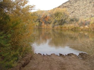
We found the trailhead easily enough and it looked like we had the place to ourselves. When we could see the sand bar we were happy to find it pretty exposed, so it looked like our watery plan was on. When we got to the water there were a bunch of people playing and swimming and they watched us drive into the water.

We all went to the sand bar and decided we were up for it, so Monica started across. The first river crossing was deep and fun, and she didn't have an issue. The water came up over her rocker guards and tires.

Julie came through with her new Jeep and she saw a bit more of the water. It came in through the seals in her closed doors, soaking the carpet, but she made it through without any problems. Walt and Mike followed her through, splashing and having a blast.

We intended to take Scharf Mesa out, but we weren't leaving without going through the second river crossing, too. So we'd need to do a bit of backtracking. We found more people at the next crossing, and they watched us go through.

The water was deeper at the second water crossing this time. Monica went across, and then everyone else followed. You have to drive upstream for a bit, and that part was shallow, thankfully. It was a really good time.

We drove out to the end of the trail and discussed if we were ready to head to Colorado. We were, and we voted on which crossing we'd do again. We all voted to do the second water crossing again, this time in the opposite direction. That part of the trail is shorter and easier, anyway.

Mike had found an easier line on the way through the first time, so Monica took it. She turned before getting to that bit of sand bar, driving just above where the little water rapids started. It was deep enough to float her a little bit, but not too much. Good times! She got out to film everyone else going through.

Julie came through, getting some good floating time in just before the other side. She soaked Monica up to the knees in the lukewarm water. Surprise! She stayed there getting a couple more soakings as Walt and Mike came through. They may have floated a little but it wasn't too bad.

This trail is such a blast! We need to do it more often. We headed over to do Buckhorn Mesa for a short distance to get to Scharf Mesa. Goodbye for now, Moab.

after_the_first_crossing
airing_down
between_crossings
cave_house_part_1
cave_house_part_2
cave_house_part_3
cave_house_part_4
cave_house_part_5
cave_house_part_6
cave_house_part_7
cave_house_part_8
first_crossing
first_view_of_the_river
first_view_of_the_sand_bar
forest_of_doom
going_in
in_the_wash
into_the_first_crossing
into_the_wash
julie_after_the_second_crossing
julie_through_the_first_crossing_part_1
julie_through_the_first_crossing_part_2
julie_through_the_first_crossing_part_3
julie_through_the_first_crossing_part_4
julie_through_the_first_crossing_part_5
julie_through_the_second_crossing_part_1
julie_through_the_second_crossing_part_2
julie_water_level
julie_with_wet_doors
kokopelli_trail_sign
mike_all_alone
mike_and_walt
mike_through_the_first_crossing_part_1
mike_through_the_first_crossing_part_2
mike_through_the_first_crossing_part_3
mike_through_the_first_crossing_part_4
mike_through_the_first_crossing_part_5
mike_through_the_first_crossing_part_6
mike_through_the_first_crossing_part_7
mike_through_the_second_crossing_part_1
mike_through_the_second_crossing_part_2
mike_through_the_second_crossing_part_3
monica_through_the_second_crossing_part_1
monica_through_the_second_crossing_part_2
monica_through_the_second_crossing_part_3
monica_through_the_second_crossing_part_4
monica_through_the_second_crossing_part_5
monica_through_the_second_crossing_part_6
monica_through_the_second_crossing_part_7
monica_with_a_wet_door
on_the_sand_bar
parked_at_the_cave_house
sand_bar
scenic_start
second_crossing
start_of_the_trail
to_the_sand_bar
view_from_the_cave_house
walt_through_the_first_crossing_part_1
walt_through_the_first_crossing_part_2
walt_through_the_first_crossing_part_3
walt_through_the_first_crossing_part_4
walt_through_the_first_crossing_part_5
walt_through_the_second_crossing

Reports from Other Days: 2

Use the arrows or dots to flip through the previews of the other reports for Dolores River. Click one of them to read more and see all of the photos from that day.

October 31, 2008

Led by Monica I.
We did the Dolores River trail last year, and it has really changed since then. They have graded the entire trail, making it wide and smooth where it had a few bumps the year before. They even graded the sand bar at the first river crossing. It’s kind of sad,…
»
  • 1
  • 2
Join Us!
If you aren’t a Member or Subscriber, you can’t see all of the content on this site. Get membership information to see why this site is best when you join and log in

Information for Subscribers

When you log in you’ll see more information here:

  • Recent Community Forum posts
  • Recent polls
  • Upcoming Events you can attend
  • Links to online users

© 2000-2019 · TrailDamage.com · Terms and Conditions · About · Contact
Trail information is only accurate on the date posted. Trails may have changed or closed since that date. Use this information for historical purposes only.
Contact the Forest Service or Bureau of Land Management for up-to-date trail information.

/* ----------------------------------------- */ /* View slug: reports-other-reports-for-same-trail-slider - start */ /* ----------------------------------------- */ /* place the prev/next controls on the sides */ .td-transition-controls .wpv-filter-next-link, .td-transition-controls .wpv-filter-previous-link { border: none; font-size: 300%; position: absolute; top: 70px; } .td-transition-controls .wpv-filter-previous-link { left: 0; } .td-transition-controls .wpv-filter-next-link { right: 0; } /* center the page selector horizonatally */ .td-transition-controls ul.wpv_pagination_dots { text-align: center; margin-top: 10px; } /* center the page selector horizonatally */ .td-transition-controls ul.wpv_pagination_dots li.wpv_pagination_dots_item, .td-transition-controls .wpv_pagination_dots li a { display: inline-block; float: none; } /* remove the default styles */ .td-transition-controls .wpv_pagination_dots li a { text-decoration: none; border-bottom: none; } .td-slider-container { padding: 0 25px; margin-bottom: 20px; position: relative; width:100%; display:table; } .td-slides { position: relative; } .td-slides-image { float:left; display:table-cell; } .td-slides-image img { border:1px solid #c0c0c0; } .td-slides-content { padding:4px 4px 4px 10px; border-top:1px solid #c0c0c0; border-right:1px solid #c0c0c0; border-bottom:1px solid #c0c0c0; display:table-cell; height:227px; overflow:hidden; } .td-slides-content h3 { margin-top:8px; } .td-slides-leader { font-size:smaller; margin-top:4px; } /* ----------------------------------------- */ /* View slug: reports-other-reports-for-same-trail-slider - end */ /* ----------------------------------------- */
/* ----------------------------------------- */ /* Content Template: Template for a Single Report - start */ /* ----------------------------------------- */ .entry-header { display:none; } .entry-content h1 { margin-top:16px; padding-top:0; } h1 a { color:#222; } h1 a:hover { color:#666; } p.entry-meta { font-size:small; } #report-body-spacer { clear:both; width:100%; height:20px; } #addtoany-bar { margin-bottom:2em; text-align:center; } .category-reports .post-info .author, .post-info .date { display: none; } .addthis_recommended_horizontal { text-align:center !important; } /* ----------------------------------------- */ /* Content Template: Template for a Single Report - end */ /* ----------------------------------------- */ /* ----------------------------------------- */ /* Content Template: Loop item in REPORTS Runners - start */ /* ----------------------------------------- */ #runners-container { width:100%; clear:both; } .runner { border:1px solid #c0c0c0; margin:0 6px 6px 0; float:left; width:49%; height:81px; } .runner-image { float: left; } .runner-image img { margin:2px 10px 0 2px; height:75px; width:75px; } .runner-name { text-transform:uppercase; } .runner-name a { color:#222; } .runner-name a:hover { color:#666; } .runner-vehicle { font-size:small; } @media only screen and (max-width: 768px) { .runner { width:100%; } } /* ----------------------------------------- */ /* Content Template: Loop item in REPORTS Runners - end */ /* ----------------------------------------- */