TrailDamage.com

Photos, videos and information about 4x4 trails in Colorado and Utah

  • Trails
    • Colorado
    • Utah
  • Reports
    • Featured Photos
    • Featured Videos
    • Reports Calendar
  • Members
  • Search
  • Trail Damage Winners
  • FAQ
  • Community
  • Upcoming Events
  • Membership
  • Log In
  • Facebook
  • Instagram
  • RSS
  • Twitter
  • YouTube

Dolores River 081031

October 31, 2008 by Monica

Dolores River

Trail Run on October 31, 2008
Report and photos by Monica I., Trail Leader
View trail information for Dolores River

Mike S.
Silver 2004 Jeep Wrangler Rubicon
Jeffrey M.
Khaki 2006 Jeep Wrangler Unlimited Rubicon
Roger R.
White 2005 Jeep Wrangler Unlimited Rubicon
Monica I.
Red 2010 Jeep Wrangler Rubicon
Michael M.
Black 2006 Jeep Wrangler Unlimited Rubicon

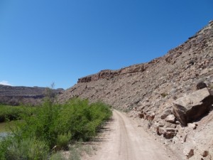
We did the Dolores River trail last year, and it has really changed since then. They have graded the entire trail, making it wide and smooth where it had a few bumps the year before. They even graded the sand bar at the first river crossing. It's kind of sad, turning a trail into a road. The river crossings are still the same, though, so the trail is still a challenge.

We started our day by airing down at the Dewey Bridge. Seeing it burned and mostly gone was depressing. It wasn't long before we had found the Dolores River trailhead and headed down to the river.

We knew where the first river crossing was this time, so Mike stopped at the first sight of it to take pictures from a new angle. Jeffrey stopped at the next view of it, at a slightly different angle for even more unique pictures. The rest of us headed down to the river.

There was a lot of dry land at the sand bar, so we figured that the water wouldn't be too deep. It was still deep, but no one floated at any point. The sand bar was graded, but the rocks in the river were still there. Monica, Michael and Roger all went through in a line.

Jeffrey and Mike left their posts and crossed the river in style. You could hear water hit Mike's fan for just a second, but then it was gone. That crossing is still so much fun!

When we got across the river, we turned right instead of left. We had big plans to explore the Dolores Triangle, and we left the Dolores River trail via the end of the Buckhorn Mesa trail.

After doing a few more trails and many miles we finally came back to the Dolores River trail where we had left it. Unfortunately, it was very nearly dark. It was also very, very dusty. We all spread out, trying to breathe in the dust. It was weird dust, and it hung in the air like a fog for a very long time.

The second river crossing was also fun, but we did it in the dark. That made it pretty cool to do but pretty bad for pictures. No one had any issues, and everyone enjoyed it.

We stopped for a bit on the other side to put in windows because it was getting chilly. With the road graded as it was, it didn't take us long to finish the trail and end up back at the Dewey Bridge to air up and head back to town. This is always a great trail, especially with the detour into the Dolores Triangle. We're definitely going to include Scharf Mesa West whenever we do Dolores River. It was a fun day!

airing_down
badger
cottonwoods
dewey_bridge
easy_trail
first_river_crossing_entry
first_river_crossing_exit
first_river_crossing_from_above_part_1
first_river_crossing_from_above_part_2
first_river_crossing_from_above_part_3
first_view_of_the_river
jeffrey_through_the_first_river_crossing_part_1
jeffrey_through_the_first_river_crossing_part_2
jeffrey_through_the_first_river_crossing_part_3
jeffrey_through_the_first_river_crossing_part_4
jeffrey_through_the_first_river_crossing_part_5
jeffrey_through_the_first_river_crossing_part_6
jeffrey_through_the_first_river_crossing_part_7
jeffrey_through_the_first_river_crossing_part_8
jeffrey_through_the_second_river_crossing
lush_desert
michael_through_the_first_river_crossing_part_1
michael_through_the_first_river_crossing_part_2
michael_through_the_first_river_crossing_part_3
michael_through_the_first_river_crossing_part_4
michael_through_the_first_river_crossing_part_5
michael_through_the_second_river_crossing
mike_through_the_first_river_crossing_part_1
mike_through_the_first_river_crossing_part_2
mike_through_the_first_river_crossing_part_3
mike_through_the_first_river_crossing_part_4
mike_through_the_first_river_crossing_part_5
mike_through_the_first_river_crossing_part_6
mike_through_the_first_river_crossing_part_7
mike_through_the_second_river_crossing
monica_michael_and_roger
monica_through_the_first_river_crossing_part_1
monica_through_the_first_river_crossing_part_2
monica_through_the_first_river_crossing_part_3
old_cabin
roger_through_the_first_river_crossing_part_1
roger_through_the_first_river_crossing_part_2
roger_through_the_first_river_crossing_part_3
roger_through_the_first_river_crossing_part_4
roger_through_the_first_river_crossing_part_5
roger_through_the_second_river_crossing
second_river_crossing_entry
second_river_crossing_part_1
second_river_crossing_part_2
start_of_the_trail
sunset

Reports from Other Days: 2

Use the arrows or dots to flip through the previews of the other reports for Dolores River. Click one of them to read more and see all of the photos from that day.

May 20, 2012

Led by Monica I.
We were heading for home with dirty Jeeps and mild sunburns. We had a long day planned, though it ended up being even longer than we anticipated. We stopped by the Cave House next to highway 128 and the Dome Plateau trailhead on the way there, just to check it…
»
  • 1
  • 2
Join Us!
If you aren’t a Member or Subscriber, you can’t see all of the content on this site. Get membership information to see why this site is best when you join and log in

Information for Subscribers

When you log in you’ll see more information here:

  • Recent Community Forum posts
  • Recent polls
  • Upcoming Events you can attend
  • Links to online users

© 2000-2021 · TrailDamage.com · Terms and Conditions · About · Contact
Trail information is only accurate on the date posted. Trails may have changed or closed since that date. Use this information for historical purposes only.
Contact the Forest Service or Bureau of Land Management for up-to-date trail information.

/* ----------------------------------------- */ /* View slug: reports-other-reports-for-same-trail-slider - start */ /* ----------------------------------------- */ /* place the prev/next controls on the sides */ .td-transition-controls .wpv-filter-next-link, .td-transition-controls .wpv-filter-previous-link { border: none; font-size: 300%; position: absolute; top: 70px; } .td-transition-controls .wpv-filter-previous-link { left: 0; } .td-transition-controls .wpv-filter-next-link { right: 0; } /* center the page selector horizonatally */ .td-transition-controls ul.wpv_pagination_dots { text-align: center; margin-top: 10px; } /* center the page selector horizonatally */ .td-transition-controls ul.wpv_pagination_dots li.wpv_pagination_dots_item, .td-transition-controls .wpv_pagination_dots li a { display: inline-block; float: none; } /* remove the default styles */ .td-transition-controls .wpv_pagination_dots li a { text-decoration: none; border-bottom: none; } .td-slider-container { padding: 0 25px; margin-bottom: 20px; position: relative; width:100%; display:table; } .td-slides { position: relative; } .td-slides-image { float:left; display:table-cell; } .td-slides-image img { border:1px solid #c0c0c0; } .td-slides-content { padding:4px 4px 4px 10px; border-top:1px solid #c0c0c0; border-right:1px solid #c0c0c0; border-bottom:1px solid #c0c0c0; display:table-cell; height:227px; overflow:hidden; } .td-slides-content h3 { margin-top:8px; } .td-slides-leader { font-size:smaller; margin-top:4px; } /* ----------------------------------------- */ /* View slug: reports-other-reports-for-same-trail-slider - end */ /* ----------------------------------------- */
/* ----------------------------------------- */ /* Content Template: Template for a Single Report - start */ /* ----------------------------------------- */ .entry-header { display:none; } .entry-content h1 { margin-top:16px; padding-top:0; } h1 a { color:#222; } h1 a:hover { color:#666; } p.entry-meta { font-size:small; } #report-body-spacer { clear:both; width:100%; height:20px; } #addtoany-bar { margin-bottom:2em; text-align:center; } .category-reports .post-info .author, .post-info .date { display: none; } .addthis_recommended_horizontal { text-align:center !important; } /* ----------------------------------------- */ /* Content Template: Template for a Single Report - end */ /* ----------------------------------------- */ /* ----------------------------------------- */ /* Content Template: Loop item in REPORTS Runners - start */ /* ----------------------------------------- */ #runners-container { width:100%; clear:both; } .runner { border:1px solid #c0c0c0; margin:0 6px 6px 0; float:left; width:49%; height:81px; } .runner-image { float: left; } .runner-image img { margin:2px 10px 0 2px; height:75px; width:75px; } .runner-name { text-transform:uppercase; } .runner-name a { color:#222; } .runner-name a:hover { color:#666; } .runner-vehicle { font-size:small; } @media only screen and (max-width: 768px) { .runner { width:100%; } } /* ----------------------------------------- */ /* Content Template: Loop item in REPORTS Runners - end */ /* ----------------------------------------- */