TrailDamage.com

Photos, videos and information about 4x4 trails in Colorado and Utah

  • Trails
    • Colorado
    • Utah
  • Reports
    • Featured Photos
    • Featured Videos
    • Reports Calendar
  • Members
  • Search
  • Trail Damage Winners
  • FAQ
  • Community
  • Upcoming Events
  • Membership
  • Log In
  • Facebook
  • Instagram
  • RSS
  • Twitter
  • YouTube

Cascade Creek 130803

August 3, 2013 by Monica

Cascade Creek

Trail Run on August 3, 2013
Report and photos by Monica I., Trail Leader
View trail information for Cascade Creek

Julie M.
Green 2012 Jeep Wrangler Unlimited Rubicon
Mike C.
Red 2012 Jeep Wrangler Unlimited Rubicon
Gary R.
Yellow 1978 Jeep CJ-7
Monica I.
Red 2010 Jeep Wrangler Rubicon
Matt K.
White 2016 Jeep Wrangler Unlimited Rubicon
Andy S.
Green 2000 Land Rover Discovery Series I

The main goal for the day was to do the rest of Cascade Creek. For years, we had been doing only part of it. It was a network of trails and we planned on seeing all of them before the day was done. We went the short distance from Devil's Canyon to the Cascade Creek trailhead and soon were on our way up.

We planned on doing the usual, short version of the trail first. When we got to the first intersection we turned right and headed uphill. We planned on coming back to that intersection again toward the end of our trip through the maze.

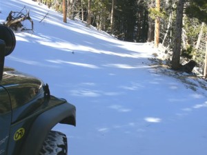
We got to the mine and didn't stop. We were looking forward to the Big Rock Hill so we just kept going. It was raining, so the rocks were slick. Luckily, the mud in this area has little to no clay in it so it wasn't very slick. However, it made some of the rocks even more fun. There were many lines to be taken through parts of the rocky obstacle, and we all chose our own way. When we got to the top, we turned right and headed down to Ute Creek Road.

Normally, we would turn right on Ute Creek Road and head back down to the highway. But we had other plans. We turned left instead and headed up to the main road on Lamartine. Then we turned left to head back into the trail system.

We went through some switchbacks and found ourselves at a tall radio tower. We didn't know it at the time, but it would be the first of three radio towers we'd see on the trail. It was in an open area but the trail kept going, and so did we. We found a truck coming the other way who said it was a little pointless at the end because the trail didn't go anywhere. Still, it was fun so we went to the end. He was right, it didn't go anywhere.

We headed back down and took another way up to the main road near the end of Spring Creek. Then we found our second radio tower. The trail to and from that tower was really rocky in spots, and it was a good time.

Next, we took 710.1 to see the rest of the trail. We found some happy and slightly lost people at the Molly Bawn Mine so we helped them figure out the best way out. Like Gary says, if you're on a trail and you still have gas then you're not lost. We kept going and they planned on heading down Saxon Mountain.

The trail to connect the two sections cuts across a very steep ridge but you can't tell that when you're on it. It's surrounded by tall trees. Though the trail is narrow it's not a shelf road at any point.

We got to the wide area at the main creek crossing and got out to discuss things. It was starting to get dark and we knew the rain was coming. We wanted to see all of the trail, though, so we got back in our vehicles to continue on.

We found a sign pointing the way to Highland Park so we followed it. That took us to our third radio tower. Everyone parked near the tower while Monica headed up to see the end. It was fairly uneventful, so the rest of the group decided to skip it. We were on our way back down when we noticed a sheet of heavy rain almost to us. We took a minute to put windows in and tops on, and we finished just before the rain came. And it was a lot of rain.

As we worked our way down and over to the last connection with the main trail near Saxon Mountain the rain got really heavy. The trail was covered in muddy water. It was actually pretty fun being out in it, especially because the mud wasn't very slick. When we got to the main intersection we turned around and headed back down.

The last remaining section of trail past the very first intersection was a good time. We passed someone on their way up, planning to camp on Saxon Mountain. That didn't sound like very much fun, but they were happy. Camping in the cold rain is still better than work, right?

The remaining rocks were fun, even on the way down. They continued to be a blast for quite a while. As we were nearing the first intersection we passed what seemed to be an old junk yard with a long fence between it and the trail. It was kind of gross and kind of fascinating. We could see lots of old and random things between gaps in the fencing.

It didn't take us long to get back to the trailhead. We all headed back to Idaho Springs to air up in the big parking lot. Andy and Matt headed for home while the rest of us had dinner in town. Even though it was a soggy day without much sunshine it was still a great time.

andy_on_the_trail
aspens
below_the_big_rock_hill
big_rock_hill
big_view
blue_sky
break_near_radio_tower_3
bumpy_hill
bumpy
cabin
carsonite
cascade_creek
chunky
deadwood
drop_off
early_climb
easy_trail
flowers_part_1
flowers_part_2
flowers_part_3
fun_climb
fun_stuff
hazy
healthy_trees
intersection_sign
intersection
julie_on_the_trail_part_1
julie_on_the_trail_part_2
little_creek_crossing
loose_rocks
loose
lots_of_rocks
main_creek_crossing_part_1
main_creek_crossing_part_2
main_trail
matt_on_the_trail
meadow
mike_on_the_trail_part_1
mike_on_the_trail_part_2
mountain_view
narrow
open_space
past_radio_tower_3
pond
powerlines
radio_tower_1
radio_tower_2
radio_tower_3
rain_coming
rocks
scenic
sign_near_creek_crossing
signs
slow_going
soggy_trail
sparse
start_of_the_big_rock_hill
start_of_the_trail
tall_trees
telephone_pole
through_trees
trailhead_signs
typical_trail
tyrone_tunnel_mine
up_to_the_mine
ute_creek_sign
wet

Reports from Other Days: 4

Use the arrows or dots to flip through the previews of the other reports for Cascade Creek. Click one of them to read more and see all of the photos from that day.

February 11, 2006

Led by Monica I.
Some of us wanted to get another snow run in and Cascade Creek seemed a good choice. It’s close to Denver in case any breakages occur, and it’s a relatively easy trail with little danger of damage or mishaps if you get bogged down in the snow. We met at…
« »
  • 1
  • 2
  • 3
  • 4
Join Us!
If you aren’t a Member or Subscriber, you can’t see all of the content on this site. Get membership information to see why this site is best when you join and log in

Information for Subscribers

When you log in you’ll see more information here:

  • Recent Community Forum posts
  • Recent polls
  • Upcoming Events you can attend
  • Links to online users

© 2000-2021 · TrailDamage.com · Terms and Conditions · About · Contact
Trail information is only accurate on the date posted. Trails may have changed or closed since that date. Use this information for historical purposes only.
Contact the Forest Service or Bureau of Land Management for up-to-date trail information.

/* ----------------------------------------- */ /* View slug: reports-other-reports-for-same-trail-slider - start */ /* ----------------------------------------- */ /* place the prev/next controls on the sides */ .td-transition-controls .wpv-filter-next-link, .td-transition-controls .wpv-filter-previous-link { border: none; font-size: 300%; position: absolute; top: 70px; } .td-transition-controls .wpv-filter-previous-link { left: 0; } .td-transition-controls .wpv-filter-next-link { right: 0; } /* center the page selector horizonatally */ .td-transition-controls ul.wpv_pagination_dots { text-align: center; margin-top: 10px; } /* center the page selector horizonatally */ .td-transition-controls ul.wpv_pagination_dots li.wpv_pagination_dots_item, .td-transition-controls .wpv_pagination_dots li a { display: inline-block; float: none; } /* remove the default styles */ .td-transition-controls .wpv_pagination_dots li a { text-decoration: none; border-bottom: none; } .td-slider-container { padding: 0 25px; margin-bottom: 20px; position: relative; width:100%; display:table; } .td-slides { position: relative; } .td-slides-image { float:left; display:table-cell; } .td-slides-image img { border:1px solid #c0c0c0; } .td-slides-content { padding:4px 4px 4px 10px; border-top:1px solid #c0c0c0; border-right:1px solid #c0c0c0; border-bottom:1px solid #c0c0c0; display:table-cell; height:227px; overflow:hidden; } .td-slides-content h3 { margin-top:8px; } .td-slides-leader { font-size:smaller; margin-top:4px; } /* ----------------------------------------- */ /* View slug: reports-other-reports-for-same-trail-slider - end */ /* ----------------------------------------- */
/* ----------------------------------------- */ /* Content Template: Template for a Single Report - start */ /* ----------------------------------------- */ .entry-header { display:none; } .entry-content h1 { margin-top:16px; padding-top:0; } h1 a { color:#222; } h1 a:hover { color:#666; } p.entry-meta { font-size:small; } #report-body-spacer { clear:both; width:100%; height:20px; } #addtoany-bar { margin-bottom:2em; text-align:center; } .category-reports .post-info .author, .post-info .date { display: none; } .addthis_recommended_horizontal { text-align:center !important; } /* ----------------------------------------- */ /* Content Template: Template for a Single Report - end */ /* ----------------------------------------- */ /* ----------------------------------------- */ /* Content Template: Loop item in REPORTS Runners - start */ /* ----------------------------------------- */ #runners-container { width:100%; clear:both; } .runner { border:1px solid #c0c0c0; margin:0 6px 6px 0; float:left; width:49%; height:81px; } .runner-image { float: left; } .runner-image img { margin:2px 10px 0 2px; height:75px; width:75px; } .runner-name { text-transform:uppercase; } .runner-name a { color:#222; } .runner-name a:hover { color:#666; } .runner-vehicle { font-size:small; } @media only screen and (max-width: 768px) { .runner { width:100%; } } /* ----------------------------------------- */ /* Content Template: Loop item in REPORTS Runners - end */ /* ----------------------------------------- */