TrailDamage.com

Photos, videos and information about 4x4 trails in Colorado and Utah

  • Trails
    • Colorado
    • Utah
  • Reports
    • Featured Photos
    • Featured Videos
    • Reports Calendar
  • Members
  • Search
  • Trail Damage Winners
  • FAQ
  • Community
  • Upcoming Events
  • Membership
  • Log In
  • Facebook
  • Instagram
  • RSS
  • Twitter
  • YouTube

Bockman Road 110717

July 17, 2011 by Monica

Bockman Road

Trail Run on July 17, 2011
Report and photos by Monica I., Trail Leader
View trail information for Bockman Road

Monica I.
Red 2010 Jeep Wrangler Rubicon
Katie L.
Blue 2004 Nissan Xterra
Austin C.
Khaki 2004 Jeep Wrangler Unlimited Rubicon
Walt S.
Gray 2018 Jeep Wrangler Unlimited Rubicon
Mike S.
Silver 2004 Jeep Wrangler Rubicon

Our day hadn't been going as planned and it would continue to be weird all the way to the end. We wanted to go see Montgomery Pass and Bockman Road before heading back in so we skipped taking the easy road north and turned off at Bockman Road.

We first headed for Diamond Peaks to do a loop with Bockman Road. But it turns out that Diamond Peaks is now an ATV trail. We also discovered that Bockman Road went all the way to the pavement so we changed our plans around a bit. It was lunchtime so we headed for the Bockman Campground.

The place was almost empty. Everyone had packed up and gone home because it was Sunday. We found a pull-through spot with a big picnic table where we could all have lunch. The weather was nice but the mosquitoes were vicious so we didn't hang out as long as we usually like to. We'd all had our share of mosquito bites already.

After lunch we headed for Montgomery Pass. We got up to where the Yurt parking was and the trail was closed. Everyone was getting pretty annoyed because there were no warnings or notices. It would have been good to be able to read a sign at the entrance station noting the closures so we could have planned our day better. Even a sign at the trailhead would have been good. We'll just have to do Montgomery Pass a different day.

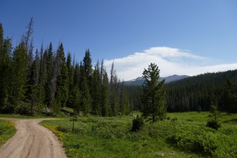
We'd all had about enough so we decided to head down Bockman Road and get home at a decent hour for a change. The trail was pretty mellow and we hoped that it would be open the entire way. It started sprinkling and we stopped at a wide spot to put in windows and doors.

It was a good thing we stopped. Mere minutes after heading out again it started really raining. And then it started hailing. Muddy water was streaming down the trail as we climbed.

Once we got over the ridge and started heading downhill the weather cleared up a bit but it still rained all the way out. There were some slick spots but no one got into any trouble.

Once we got to the trailhead we found two employees of the State Forest State Park on a UTV. We talked with them a bit and they were very friendly and helpful. After a short chat we headed across the highway to air up.

It was the middle of the afternoon so we just headed for home. We didn't even stop to do Kelly Flats (though we talked about it). It was a long and mosquito-filled weekend and we were all looking forward to getting back home. We'll need to come back again to do the trails we missed, so we'll be back.

around_a_curve
bumpy_trail
diamond_peaks_sign
diamond_peaks
intersection
lunch
mountain_view
muddy
northern_end
northern_sign
sloppy
southern_intersection
tall_trees
trailhead_sign_1
trailhead_sign_2

Report from a Different Day

June 15, 2018

Led by Monica I.
It was time we got back to the lush trails in State Forest State Park.  This time, we were camping at the Ranger Lakes Campground and it was amazing.  Mike and Monica showed up the night before in their motor homes, and Niko showed up in the morning.  Monica was…
Join Us!
If you aren’t a Member or Subscriber, you can’t see all of the content on this site. Get membership information to see why this site is best when you join and log in

Information for Subscribers

When you log in you’ll see more information here:

  • Recent Community Forum posts
  • Recent polls
  • Upcoming Events you can attend
  • Links to online users

© 2000-2022 · TrailDamage.com · Terms and Conditions · About · Contact
Trail information is only accurate on the date posted. Trails may have changed or closed since that date. Use this information for historical purposes only.
Contact the Forest Service or Bureau of Land Management for up-to-date trail information.

/* ----------------------------------------- */ /* View slug: reports-other-reports-for-same-trail-slider - start */ /* ----------------------------------------- */ /* place the prev/next controls on the sides */ .td-transition-controls .wpv-filter-next-link, .td-transition-controls .wpv-filter-previous-link { border: none; font-size: 300%; position: absolute; top: 70px; } .td-transition-controls .wpv-filter-previous-link { left: 0; } .td-transition-controls .wpv-filter-next-link { right: 0; } /* center the page selector horizonatally */ .td-transition-controls ul.wpv_pagination_dots { text-align: center; margin-top: 10px; } /* center the page selector horizonatally */ .td-transition-controls ul.wpv_pagination_dots li.wpv_pagination_dots_item, .td-transition-controls .wpv_pagination_dots li a { display: inline-block; float: none; } /* remove the default styles */ .td-transition-controls .wpv_pagination_dots li a { text-decoration: none; border-bottom: none; } .td-slider-container { padding: 0 25px; margin-bottom: 20px; position: relative; width:100%; display:table; } .td-slides { position: relative; } .td-slides-image { float:left; display:table-cell; } .td-slides-image img { border:1px solid #c0c0c0; } .td-slides-content { padding:4px 4px 4px 10px; border-top:1px solid #c0c0c0; border-right:1px solid #c0c0c0; border-bottom:1px solid #c0c0c0; display:table-cell; height:227px; overflow:hidden; } .td-slides-content h3 { margin-top:8px; } .td-slides-leader { font-size:smaller; margin-top:4px; } /* ----------------------------------------- */ /* View slug: reports-other-reports-for-same-trail-slider - end */ /* ----------------------------------------- */
/* ----------------------------------------- */ /* Content Template: Template for a Single Report - start */ /* ----------------------------------------- */ .entry-header { display:none; } .entry-content h1 { margin-top:16px; padding-top:0; } h1 a { color:#222; } h1 a:hover { color:#666; } p.entry-meta { font-size:small; } #report-body-spacer { clear:both; width:100%; height:20px; } #addtoany-bar { margin-bottom:2em; text-align:center; } .category-reports .post-info .author, .post-info .date { display: none; } .addthis_recommended_horizontal { text-align:center !important; } /* ----------------------------------------- */ /* Content Template: Template for a Single Report - end */ /* ----------------------------------------- */ /* ----------------------------------------- */ /* Content Template: Loop item in REPORTS Runners - start */ /* ----------------------------------------- */ #runners-container { width:100%; clear:both; } .runner { border:1px solid #c0c0c0; margin:0 6px 6px 0; float:left; width:49%; height:81px; } .runner-image { float: left; } .runner-image img { margin:2px 10px 0 2px; height:75px; width:75px; } .runner-name { text-transform:uppercase; } .runner-name a { color:#222; } .runner-name a:hover { color:#666; } .runner-vehicle { font-size:small; } @media only screen and (max-width: 768px) { .runner { width:100%; } } /* ----------------------------------------- */ /* Content Template: Loop item in REPORTS Runners - end */ /* ----------------------------------------- */