TrailDamage.com

Photos, videos and information about 4x4 trails in Colorado and Utah

  • Trails
    • Colorado
    • Utah
  • Reports
    • Featured Photos
    • Featured Videos
    • Reports Calendar
  • Members
  • Search
  • Trail Damage Winners
  • FAQ
  • Community
  • Upcoming Events
  • Membership
  • Log In
  • Facebook
  • Instagram
  • RSS
  • Twitter
  • YouTube

Bill Moore Lake 071117

November 17, 2007 by Mike Shannon

Bill Moore Lake

Trail Run on November 17, 2007
Report and photos by Mike S., Trail Leader
View trail information for Bill Moore Lake

Bill S.
Yellow 2020 Jeep Wrangler Rubicon
Mike S.
Silver 2004 Jeep Wrangler Rubicon
Chad S.
Blue 2004 Jeep Wrangler
Michael M.
Black 2006 Jeep Wrangler Unlimited Rubicon
Don W.
Silver 2005 Jeep Wrangler Rubicon

We had completed Red Elephant Hill and Mill Creek, and now it was time to finish up our day with Bill Moore Lake. Chad had been there the weekend before and said that there was a lot of snow on the steep downhill section before the old mud pit, so he had turned around. We hoped to make it through there and to the lake, so we started up the whoopdeedoo hill and up the mountain.

We didn't see any snow on the trail for awhile. The rocky hill with two optional routes was a blast as it was very loose and steep. We went up the middle and came down the outside on our way back.

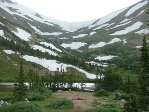
When we got to the more exposed area at the top, we noticed older snow in big drifts. It must have been from the snow we had about a month ago. There was still a lot of it to the sides of the trail, and it looked very wind-blown. So did the trees, like always. We wondered how anything could survive up there in that wind.

We could see the basin that we knew was behind the lake, and it looked like it was snowing there. We had sunshine at times, and our weather wasn't too bad. It looked like it might get bad, though.

When we got to the first downhill section we noticed it was covered in snow. We also found two people trying to push a dirtbike up the hill. They couldn't get enough traction to ride it up, and with the snow and the steep hill they were having a hard time pushing it. Don got out to help and together they all managed to push that dirtbike and an additional dirtbike up the hill and to the dirt trail.

Don went down first and found that the first section wasn't slick at all. Chad said that he did the first section the week before, but didn't do the second section with the bigger, steeper hill. It definitely had snow on it, but we had winches and we could get out if we got into any trouble.

Don went down the second hill and though the snow was a little deep in places he didn't slide toward the edge. He was soon down and he radioed for the others to come down, too. We all made it down just fine.

The snow was a few inches deep on the trail in spots, but nothing too difficult. When we got to the old mud pit we noticed that lots of ATV and dirt bike tracks went through the trees and off of the actual trail. It's possible that they just didn't know where the true trail was, but the true trail was covered in fairly deep snow.

Don had to work at it for a bit in order to break through the deep snow on the trail next to the mud pit. It didn't take long for him to get through, though, and then everyone else came through. That would be the deepest area of snow, by far. We wouldn't have any more snow bashing to do.

We were soon at the lake, and no one felt like hiking over to it. It was very cold, but it wasn't snowing. It was windy, of course.

Michael, Chad and Don all took turns getting up on the poser rock. Bill and Mike had been on it before and chose to skip it this time. It's always so much fun to get up on that rock, and everyone enjoyed themselves. Still, it was freezing so we soon headed out.

The trip down was fun, and we didn't see any snow after we passed the open area that we had already been through. The whole way down was nice and easy. We saw a couple of vehicles working their way up.

The very last part of the trail right before the trailhead is very mellow, but there are some nice cracks in the road. We all drove through an especially deep crack to get some flexy shots, and we realized that it would be months before we were flexed again. The end of the season is always such a bittersweet time.

We aired up at the trailhead and almost all of us went to Beau Jo's for dinner. We looked forward to the Georgetown Ice Races coming up, but it wasn't quite the same as wheeling. It was going to be a long winter!

big_view
bill_and_chad
bill_flexing_part_1
bill_flexing_part_2
bill_moore_lake
chad_flexing_part_1
chad_flexing_part_2
chad_posing_part_1
chad_posing_part_2
chad_posing_part_3
chad_posing_part_4
conqueror_mine
cool_trees
don_posing_part_1
don_posing_part_2
don_posing_part_3
down_to_the_trailhead
getting_deeper
jeeps
michael_posing_part_1
michael_posing_part_2
michael_through_the_flexy_spot
mike_flexing_part_1
mike_flexing_part_2
mike_flexing_part_3
mike_trail_damage
poser_rock
snow_drifts
snowy_downhill
trench
weathered_tree
worst_of_it

Reports from Other Days: 9

Use the arrows or dots to flip through the previews of the other reports for Bill Moore Lake. Click one of them to read more and see all of the photos from that day.

July 31, 2004

Led by Monica I.
We ran this trail right after running Red Elephant Hill and it was a blast like always. Red Elephant Hill had claimed a few members (Derek S., Robert and Wayne all had to turn around) but we still had a large group for Bill Moore Lake. We did the flexy…
« »
  • 1
  • 2
  • 3
  • 4
  • 5
  • 6
  • 7
  • 8
  • 9
Join Us!
If you aren’t a Member or Subscriber, you can’t see all of the content on this site. Get membership information to see why this site is best when you join and log in

Information for Subscribers

When you log in you’ll see more information here:

  • Recent Community Forum posts
  • Recent polls
  • Upcoming Events you can attend
  • Links to online users

© 2000-2023 · TrailDamage.com · Terms and Conditions · About · Contact
Trail information is only accurate on the date posted. Trails may have changed or closed since that date. Use this information for historical purposes only.
Contact the Forest Service or Bureau of Land Management for up-to-date trail information.

/* ----------------------------------------- */ /* View slug: reports-other-reports-for-same-trail-slider - start */ /* ----------------------------------------- */ /* place the prev/next controls on the sides */ .td-transition-controls .wpv-filter-next-link, .td-transition-controls .wpv-filter-previous-link { border: none; font-size: 300%; position: absolute; top: 70px; } .td-transition-controls .wpv-filter-previous-link { left: 0; } .td-transition-controls .wpv-filter-next-link { right: 0; } /* center the page selector horizonatally */ .td-transition-controls ul.wpv_pagination_dots { text-align: center; margin-top: 10px; } /* center the page selector horizonatally */ .td-transition-controls ul.wpv_pagination_dots li.wpv_pagination_dots_item, .td-transition-controls .wpv_pagination_dots li a { display: inline-block; float: none; } /* remove the default styles */ .td-transition-controls .wpv_pagination_dots li a { text-decoration: none; border-bottom: none; } .td-slider-container { padding: 0 25px; margin-bottom: 20px; position: relative; width:100%; display:table; } .td-slides { position: relative; } .td-slides-image { float:left; display:table-cell; } .td-slides-image img { border:1px solid #c0c0c0; } .td-slides-content { padding:4px 4px 4px 10px; border-top:1px solid #c0c0c0; border-right:1px solid #c0c0c0; border-bottom:1px solid #c0c0c0; display:table-cell; height:227px; overflow:hidden; } .td-slides-content h3 { margin-top:8px; } .td-slides-leader { font-size:smaller; margin-top:4px; } /* ----------------------------------------- */ /* View slug: reports-other-reports-for-same-trail-slider - end */ /* ----------------------------------------- */
/* ----------------------------------------- */ /* Content Template: Template for a Single Report - start */ /* ----------------------------------------- */ .entry-header { display:none; } .entry-content h1 { margin-top:16px; padding-top:0; } h1 a { color:#222; } h1 a:hover { color:#666; } p.entry-meta { font-size:small; } #report-body-spacer { clear:both; width:100%; height:20px; } #addtoany-bar { margin-bottom:2em; text-align:center; } .category-reports .post-info .author, .post-info .date { display: none; } .addthis_recommended_horizontal { text-align:center !important; } /* ----------------------------------------- */ /* Content Template: Template for a Single Report - end */ /* ----------------------------------------- */ /* ----------------------------------------- */ /* Content Template: Loop item in REPORTS Runners - start */ /* ----------------------------------------- */ #runners-container { width:100%; clear:both; } .runner { border:1px solid #c0c0c0; margin:0 6px 6px 0; float:left; width:49%; height:81px; } .runner-image { float: left; } .runner-image img { margin:2px 10px 0 2px; height:75px; width:75px; } .runner-name { text-transform:uppercase; } .runner-name a { color:#222; } .runner-name a:hover { color:#666; } .runner-vehicle { font-size:small; } @media only screen and (max-width: 768px) { .runner { width:100%; } } /* ----------------------------------------- */ /* Content Template: Loop item in REPORTS Runners - end */ /* ----------------------------------------- */