TrailDamage.com

Photos, videos and information about 4x4 trails in Colorado and Utah

  • Trails
    • Colorado
    • Utah
  • Reports
    • Featured Photos
    • Featured Videos
    • Reports Calendar
  • Members
  • Search
  • Trail Damage Winners
  • FAQ
  • Community
  • Upcoming Events
  • Membership
  • Log In
  • Facebook
  • Instagram
  • RSS
  • Twitter
  • YouTube

Bill Moore Lake 050709

July 9, 2005 by Monica

Bill Moore Lake

Trail Run on July 9, 2005
Report and photos by Monica I., Trail Leader
View trail information for Bill Moore Lake

Cheryl W.
Orange 2006 Jeep Wrangler Unlimited Rubicon
Aaron N.
Maroon 2003 Jeep Wrangler Rubicon
Wayne B.
Silver 2003 Jeep Wrangler Rubicon
Brian E.
White 1998 Jeep Wrangler
Monica I.
Red 2010 Jeep Wrangler Rubicon
Dane R.
Silver 2007 Jeep Wrangler Rubicon
Dave B.
Black 2004 Jeep Wrangler Rubicon
Bob S.
Green 1997 Jeep Wrangler
Eric B.
Green 2000 Jeep Wrangler
Mike S.
Silver 2004 Jeep Wrangler Rubicon
Jed P.
Green 1998 Jeep Wrangler

We ran this trail after running Red Elephant Hill and Mill Creek. The weather was still nice when we started up the hill of whoopdeedoos, but the clouds over the mountains to the west were looking a little mean.

We let a Jeep Grand Cherokee (WJ) go in front of us as they were going much faster than we were. We didn't see them again so they must have taken another spur. We also passed another vehicle on the way up the big hill, and the driver told us the muddy area we were concerned about was pretty dry.

When we started getting to the area of the trail with the gnarled "Wizard of Oz" trees there were patches of snow, then large snow drifts in places. None of the drifts were over the trail so we didn't have an issue.

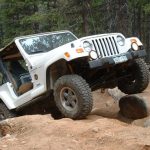
The mud pit was still closed and completely full of muddy water all the way to the top. Due to a large snow drift next to the trail around the mud pit, the trail here was still pretty muddy for a small section. The places around the rock next to the mud pit had obviously been very wet recently and they were pretty chewed up. It looked like a lot of people had been playing up here recently, many of them off the trail.

We didn't stick around -- we wanted to see the lake. Dave had a geocache he wanted to see that was past the mud pits to the right of the trail, but we decided to check it out on the way back so we could enjoy the sun at the lake.

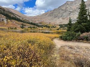
It was sunny when we got there but it didn't last too long. There was still a lot of snow on the mountains around the lake but there wasn't any around the turnaround area.

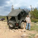
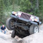
Most of us took turns posing on the rock and taking pictures. A lot of people climbed up to sit on their front bumpers and discovered that a Jeep hood does get pretty hot.

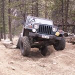
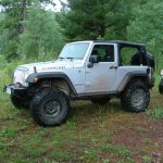
It started to rain a little bit so some people put on windows and doors if they had them (our group was all Jeep Wrangler TJs at that point). We started down and it really started to get cold and rainy at that point, with a decent wind blowing the rain in our drivers side doors. Some people in the back decided to put on doors and windows while the front of the group hurried down to get out of the rain. When we got to a place where we weren't right in the rain we stopped to regroup.

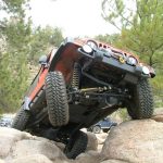
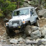
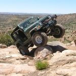
The chutes near the trailhead seemed to be cleared of a lot of the larger rocks, which was disappointing. There were a few larger ones but not as many as before. This section was a bit easier than it was in former years.

We aired up and reconnected at the trailhead. The weather was nice again as we went back to Idaho Springs for dinner. We managed to have a large group and do three trails with a later start and still finish with lots of time for dinner. It was a great day!

at_the_lake
barbie
bill_moore_lake
bob_posing_part_1
bob_posing_part_2
bob_posing_part_3
bob_posing_part_4
bob_posing_part_5
bob_posing_part_6
bob_posing_part_7
bob_posing_part_8
bob_posing_part_9
break_time
cabin_at_the_lake
cheryl_dane_and_brian
cheryl_posing_part_1
cheryl_posing_part_2
cheryl_posing_part_3
cheryl_posing_part_4
cheryl_posing_part_5
cheryl_posing_part_6
cheryl_posing_part_7
cheryl_posing_part_8
dane_posing_part_1
dane_posing_part_2
dane_posing_part_3
dane_posing_part_4
dave_posing_part_1
dave_posing_part_2
dave_posing_part_3
dave_posing_part_4
dave_posing_part_5
dave_posing_part_6
dave_posing_part_7
eric_posing_part_1
eric_posing_part_2
eric_posing_part_3
eric_posing_part_4
eric_posing_part_5
eric_posing_part_6
eric_posing_part_7
geocaching
georgetown
half_dead_half_alive_tree
in_the_snow
jed_and_more_jeeps
jed_posing_part_1
jed_posing_part_2
jed_posing_part_3
jed_posing_part_4
jed_posing_part_5
jed_posing_part_6
jed_posing_part_7
jed_posing_part_8
jed_posing_part_9
jeeps
lake_view
lots_of_snow
mellow_road
mike_on_the_trail
mike_posing_part_1
mike_posing_part_2
mike_posing_part_3
mike_posing_part_4
mike_posing_part_5
mike_posing_part_6
monica_at_the_lake
monica_posing_part_1
monica_posing_part_2
monica_posing_part_3
monica_posing_part_4
monica_posing_part_5
monica_posing_part_6
monica_posing_part_7
muddy_section
slow_climb
snow
snowman_in_july
snowy_mountains
view_of_our_destination
weird_trees
wild_flowers

Reports from Other Days: 9

Use the arrows or dots to flip through the previews of the other reports for Bill Moore Lake. Click one of them to read more and see all of the photos from that day.

July 6, 2019

Led by Sean C.
After completing the Mill Creek Loop, we came to the turnoff to Bill Moore Lake. It can be confusing after the three-way turn to find the trail to the lake. We turned right at the first intersection after the creek crossing and then went uphill. We knew we had found…
»
  • 1
  • 2
  • 3
  • 4
  • 5
  • 6
  • 7
  • 8
  • 9
Join Us!
If you aren’t a Member or Subscriber, you can’t see all of the content on this site. Get membership information to see why this site is best when you join and log in

Information for Subscribers

When you log in you’ll see more information here:

  • Recent Community Forum posts
  • Recent polls
  • Upcoming Events you can attend
  • Links to online users

© 2000-2022 · TrailDamage.com · Terms and Conditions · About · Contact
Trail information is only accurate on the date posted. Trails may have changed or closed since that date. Use this information for historical purposes only.
Contact the Forest Service or Bureau of Land Management for up-to-date trail information.

/* ----------------------------------------- */ /* View slug: reports-other-reports-for-same-trail-slider - start */ /* ----------------------------------------- */ /* place the prev/next controls on the sides */ .td-transition-controls .wpv-filter-next-link, .td-transition-controls .wpv-filter-previous-link { border: none; font-size: 300%; position: absolute; top: 70px; } .td-transition-controls .wpv-filter-previous-link { left: 0; } .td-transition-controls .wpv-filter-next-link { right: 0; } /* center the page selector horizonatally */ .td-transition-controls ul.wpv_pagination_dots { text-align: center; margin-top: 10px; } /* center the page selector horizonatally */ .td-transition-controls ul.wpv_pagination_dots li.wpv_pagination_dots_item, .td-transition-controls .wpv_pagination_dots li a { display: inline-block; float: none; } /* remove the default styles */ .td-transition-controls .wpv_pagination_dots li a { text-decoration: none; border-bottom: none; } .td-slider-container { padding: 0 25px; margin-bottom: 20px; position: relative; width:100%; display:table; } .td-slides { position: relative; } .td-slides-image { float:left; display:table-cell; } .td-slides-image img { border:1px solid #c0c0c0; } .td-slides-content { padding:4px 4px 4px 10px; border-top:1px solid #c0c0c0; border-right:1px solid #c0c0c0; border-bottom:1px solid #c0c0c0; display:table-cell; height:227px; overflow:hidden; } .td-slides-content h3 { margin-top:8px; } .td-slides-leader { font-size:smaller; margin-top:4px; } /* ----------------------------------------- */ /* View slug: reports-other-reports-for-same-trail-slider - end */ /* ----------------------------------------- */
/* ----------------------------------------- */ /* Content Template: Template for a Single Report - start */ /* ----------------------------------------- */ .entry-header { display:none; } .entry-content h1 { margin-top:16px; padding-top:0; } h1 a { color:#222; } h1 a:hover { color:#666; } p.entry-meta { font-size:small; } #report-body-spacer { clear:both; width:100%; height:20px; } #addtoany-bar { margin-bottom:2em; text-align:center; } .category-reports .post-info .author, .post-info .date { display: none; } .addthis_recommended_horizontal { text-align:center !important; } /* ----------------------------------------- */ /* Content Template: Template for a Single Report - end */ /* ----------------------------------------- */ /* ----------------------------------------- */ /* Content Template: Loop item in REPORTS Runners - start */ /* ----------------------------------------- */ #runners-container { width:100%; clear:both; } .runner { border:1px solid #c0c0c0; margin:0 6px 6px 0; float:left; width:49%; height:81px; } .runner-image { float: left; } .runner-image img { margin:2px 10px 0 2px; height:75px; width:75px; } .runner-name { text-transform:uppercase; } .runner-name a { color:#222; } .runner-name a:hover { color:#666; } .runner-vehicle { font-size:small; } @media only screen and (max-width: 768px) { .runner { width:100%; } } /* ----------------------------------------- */ /* Content Template: Loop item in REPORTS Runners - end */ /* ----------------------------------------- */