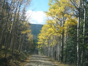
TrailDamage.com

Photos, videos and information about 4x4 trails in Colorado and Utah

  • Trails
    • Colorado
    • Utah
  • Reports
    • Featured Photos
    • Featured Videos
    • Reports Calendar
  • Members
  • Search
  • Trail Damage Winners
  • FAQ
  • Community
  • Upcoming Events
  • Membership
  • Log In
  • Facebook
  • Instagram
  • RSS
  • Twitter
  • YouTube

Ballard Road 130720

July 20, 2013 by Monica

Ballard Road

Trail Run on July 20, 2013
Report and photos by Monica I., Trail Leader
View trail information for Ballard Road

Matt K.
White 2016 Jeep Wrangler Unlimited Rubicon
Monica I.
Red 2010 Jeep Wrangler Rubicon
Roger R.
Gray 2021 Jeep Wrangler Rubicon 4xe
Julie M.
Green 2012 Jeep Wrangler Unlimited Rubicon
Jerry V.
Orange 1987 Jeep Wrangler

Though we had already done more than half of Pennock Pass, it was Ballard Road and Greer Road South we were really looking forward to for the day. We found the trailhead easily enough and headed south. It would be a day of wandering around.

We saw the trailhead for Greer Road South but we decided to save it for later. Ballard Road is an "out and back" trail so we would pass by it again.

The trail was muddy, with big ruts in spots. We started seeing lots of cars coming in the other direction -- cars, not four-wheel drive or AWD vehicles. It was slick and muddy, and all of the drivers were young. Where was everyone coming from?

When we got to the first spur we decided to head over to the fun part of Greer Road South. It wasn't long before we found where all of the cars were coming from. There were many cars parked near the really muddy curve, and we found an older model stuck in a deep and muddy rut. The driver and other onlookers seemed pretty stoned and clueless, so we stopped to help. Monica winched the car out enough to get it rolling again, and we kept going.

We stopped soon after that to have lunch in the trees. It looked like it was going to rain, and it did at the end of our lunch. It was a good time to stop, but we ate listening to loud music from the kids in the mud at the bottom of the hill.

We did the far end of Greer Road South and headed back to finish Ballard Road. By the time we got to the muddy area the police were there in two trucks and all of the kids looked pretty unhappy. The cops asked us if we were "the Jeeps" so apparently they heard the story. We said we were, and that's all they wanted to know so we kept going.

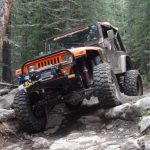
The southern spur on Ballard Road is narrower and more interesting. It's a bit rocky, and it goes by many piles of old timbers. We stopped at the far end and took a break. The timbers were definitely weird and we couldn't figure them out. Why were they there? Weird!

We headed out to the trailhead. Julie and Jerry didn't do the other section of Greer Road South, so Monica, Matt, and Roger continued on. It ended up being fairly uneventful, anyway. Ballard Road was definitely interesting!

blue_and_green
bumpy
challenge
climb
dead_trees
exploring
fun_stuff
ledge
mellow
muddy
near_the_end
parked_at_the_end_part_1
parked_at_the_end_part_2
pulling_a_car_out
rocks
shaded_rocks
start_of_the_trail
stuck_kids
tall_trees
timber_part_1
timber_part_2
timber_part_3
timber_part_4
wet_rocks

Reports from Other Days: 2

Use the arrows or dots to flip through the previews of the other reports for Ballard Road. Click one of them to read more and see all of the photos from that day.

October 9, 2010

Led by Matt K.
It was a gorgeous morning, one that was perfect for a day of exploring. We ended up getting a late start due to alarm clock issues, but we were eventually on our way. There were eight in our group and it was a little difficult keeping everyone together as we…
»
  • 1
  • 2
Join Us!
If you aren’t a Member or Subscriber, you can’t see all of the content on this site. Get membership information to see why this site is best when you join and log in

Information for Subscribers

When you log in you’ll see more information here:

  • Recent Community Forum posts
  • Recent polls
  • Upcoming Events you can attend
  • Links to online users

© 2000-2023 · TrailDamage.com · Terms and Conditions · About · Contact
Trail information is only accurate on the date posted. Trails may have changed or closed since that date. Use this information for historical purposes only.
Contact the Forest Service or Bureau of Land Management for up-to-date trail information.

/* ----------------------------------------- */ /* View slug: reports-other-reports-for-same-trail-slider - start */ /* ----------------------------------------- */ /* place the prev/next controls on the sides */ .td-transition-controls .wpv-filter-next-link, .td-transition-controls .wpv-filter-previous-link { border: none; font-size: 300%; position: absolute; top: 70px; } .td-transition-controls .wpv-filter-previous-link { left: 0; } .td-transition-controls .wpv-filter-next-link { right: 0; } /* center the page selector horizonatally */ .td-transition-controls ul.wpv_pagination_dots { text-align: center; margin-top: 10px; } /* center the page selector horizonatally */ .td-transition-controls ul.wpv_pagination_dots li.wpv_pagination_dots_item, .td-transition-controls .wpv_pagination_dots li a { display: inline-block; float: none; } /* remove the default styles */ .td-transition-controls .wpv_pagination_dots li a { text-decoration: none; border-bottom: none; } .td-slider-container { padding: 0 25px; margin-bottom: 20px; position: relative; width:100%; display:table; } .td-slides { position: relative; } .td-slides-image { float:left; display:table-cell; } .td-slides-image img { border:1px solid #c0c0c0; } .td-slides-content { padding:4px 4px 4px 10px; border-top:1px solid #c0c0c0; border-right:1px solid #c0c0c0; border-bottom:1px solid #c0c0c0; display:table-cell; height:227px; overflow:hidden; } .td-slides-content h3 { margin-top:8px; } .td-slides-leader { font-size:smaller; margin-top:4px; } /* ----------------------------------------- */ /* View slug: reports-other-reports-for-same-trail-slider - end */ /* ----------------------------------------- */
/* ----------------------------------------- */ /* Content Template: Template for a Single Report - start */ /* ----------------------------------------- */ .entry-header { display:none; } .entry-content h1 { margin-top:16px; padding-top:0; } h1 a { color:#222; } h1 a:hover { color:#666; } p.entry-meta { font-size:small; } #report-body-spacer { clear:both; width:100%; height:20px; } #addtoany-bar { margin-bottom:2em; text-align:center; } .category-reports .post-info .author, .post-info .date { display: none; } .addthis_recommended_horizontal { text-align:center !important; } /* ----------------------------------------- */ /* Content Template: Template for a Single Report - end */ /* ----------------------------------------- */ /* ----------------------------------------- */ /* Content Template: Loop item in REPORTS Runners - start */ /* ----------------------------------------- */ #runners-container { width:100%; clear:both; } .runner { border:1px solid #c0c0c0; margin:0 6px 6px 0; float:left; width:49%; height:81px; } .runner-image { float: left; } .runner-image img { margin:2px 10px 0 2px; height:75px; width:75px; } .runner-name { text-transform:uppercase; } .runner-name a { color:#222; } .runner-name a:hover { color:#666; } .runner-vehicle { font-size:small; } @media only screen and (max-width: 768px) { .runner { width:100%; } } /* ----------------------------------------- */ /* Content Template: Loop item in REPORTS Runners - end */ /* ----------------------------------------- */