TrailDamage.com

Photos, videos and information about 4x4 trails in Colorado and Utah

  • Trails
    • Colorado
    • Utah
  • Reports
    • Featured Photos
    • Featured Videos
    • Reports Calendar
  • Members
  • Search
  • Trail Damage Winners
  • FAQ
  • Community
  • Upcoming Events
  • Membership
  • Log In
  • Facebook
  • Instagram
  • RSS
  • Twitter
  • YouTube

Williams Pass 080802

August 2, 2008 by Monica

Williams Pass

Trail Run on August 2, 2008
Report and photos by Monica I., Trail Leader
View trail information for Williams Pass

Mark U.
Red 1989 Jeep Wrangler
Don W.
Silver 2005 Jeep Wrangler Rubicon
Walt S.
Gray 2022 Jeep Wrangler Unlimited Rubicon 392
Matt K.
White 2016 Jeep Wrangler Unlimited Rubicon
Bill S.
Yellow 2020 Jeep Wrangler Rubicon
Rich M.
Red 2006 Jeep Commander
Steve B.
Green 2000 Jeep Wrangler
Brian D.
Brown 1978 International Scout II
Monica I.
Red 2010 Jeep Wrangler Rubicon
Mike S.
Silver 2004 Jeep Wrangler Rubicon

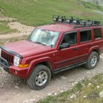
Williams Pass was almost the whole point of this trip. We knew that the trail was only open in August, and we had the day planned many months in advance. As the day approached, we called the forest service and they thought that it would be open in time.

They normally open it on August 1st, and that was the day before this run. We called in the middle of the afternoon, but the forest service said that it didn't end up getting opened. What a drag! We still wanted to do the other trails, though, so we headed out. We were a little bummed, but everyone was in a good mood.

We did Pomeroy Lakes instead, thinking that now we had the time. When we came around Hancock Pass near the Alpine Tunnel, we were surprised to see that Williams Pass was open! It was a little later in the day than we had hoped it would be when we started this trail, but we decided to go for it anyway.

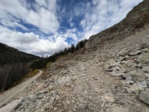
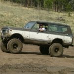
The start of the trail right at the trailhead ended up being quite challenging. Everyone had fun, and it looked a little scary with people tipping sideways next to the edge of a very big drop-off. We all made it through, though.

There was a section on the trail just past the first gate where you had to weave around the rocks a bit to get through. Mark decided he'd try to power through instead, and ended up sliding his rear end around and getting hopelessly stuck. It took a little muscle and creativity, but he managed to get free.

After the initial rocks, the trail mellowed out. You could tell it wasn't traveled very often, but it wasn't overgrown. We came around a corner and found the red rocks, and then the fun began.

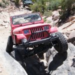
They were wet, and some of them were pretty big. We all worked on the rocks on our own, and everyone made it through. The scenery was amazing, but it was difficult to look at it as well as the challenging trail.

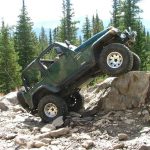
The rocks turned to a muddy mess, and we started climbing a bit more. It was so much fun! There were some big rocks that some people avoided while others went over them. We all picked the lines that worked for us.

We stopped at the pass itself, after the rocks ended and before the mud. We had heard of the infamous mud at Williams Pass, but it turned out to be nothing much to worry about. The hole was fairly deep, but the mud wasn't. We all got through without too much effort, and everyone was grinning.

The way down was much like the majority of Hancock Pass. It was bumpy and pretty in places, but not challenging. The wildflowers were out, though, making it very scenic.

We kept hoping that the gates on the other side would be open. The start and end are in two different counties, after all. What if one forest service hadn't opened their end?

We got to the inner gate and found it open, and then found the final gate open as well. We were all very happy! We finished Hancock Pass and aired up before the sun went down, and we had a nice dinner in Johnson Village at the Coyote Cantina. It was a fantastic end to a fantastic day! We all felt lucky to have experienced this trail.

at_the_trailhead
bill_at_the_trailhead
bill_through_the_mud_part_1
bill_through_the_mud_part_2
bill_through_the_mud_part_3
bill_through_the_mud_part_4
brian_at_the_trailhead
brian_through_the_mud_part_1
brian_through_the_mud_part_2
brian_through_the_mud_part_3
brian_through_the_mud_part_4
brian_through_the_mud_part_5
bumpy
climbing_wet_rocks
columbines
descending
don_muddy
don_through_the_mud_part_1
don_through_the_mud_part_2
don_through_the_mud_part_3
don_through_the_mud_part_4
don_through_the_mud_part_5
early_trail
final_gate
green_view_from_the_pass
green
guestbook
inner_gate
little-used_trail
mark_at_the_trailhead
mark_stuck_part_1
mark_stuck_part_2
mark_through_the_mud_part_1
mark_through_the_mud_part_2
mark_through_the_mud_part_3
mark_through_the_mud_part_4
marshy
matt_and_rich
matt_at_the_trailhead
matt_through_the_mud_part_1
matt_through_the_mud_part_2
matt_through_the_mud_part_3
matt_through_the_mud_part_4
mellow_trail
mike_at_the_trailhead
mike_through_the_mud_part_1
mike_through_the_mud_part_2
mike_through_the_mud_part_3
mike_through_the_mud_part_4
mike_through_the_mud_part_5
monica_through_the_mud_part_1
monica_through_the_mud_part_2
monica_through_the_mud_part_3
monica_through_the_mud_part_4
mud_part_1
mud_part_2
mud_part_3
red_rocks_and_water
rich_around_a_corner
rich_at_the_gate
rich_at_the_trailhead
rich_on_the_trail
rich_through_the_mud_part_1
rich_through_the_mud_part_2
rich_through_the_mud_part_3
rich_through_the_mud_part_4
sawmill_curve_sign
sign_at_the_end
sign_at_the_far_end
starting_the_trail
steve_at_the_trailhead
steve_through_the_mud_part_1
steve_through_the_mud_part_2
steve_through_the_mud_part_3
steve_through_the_mud_part_4
steve_through_the_mud_part_5
trailhead_sign
view_from_the_pass
view_from_the_trailhead
view_of_the_valley
walt_at_the_trailhead
walt_through_the_mud_part_1
walt_through_the_mud_part_2
walt_through_the_mud_part_3
walt_through_the_mud_part_4
walt_through_the_mud_part_5
water_near_the_end
water_on_the_trail
wildflowers
Join Us!
If you aren’t a Member or Subscriber, you can’t see all of the content on this site. Get membership information to see why this site is best when you join and log in

Information for Subscribers

When you log in you’ll see more information here:

  • Recent Community Forum posts
  • Recent polls
  • Upcoming Events you can attend
  • Links to online users

© 2000-2023 · TrailDamage.com · Terms and Conditions · About · Contact
Trail information is only accurate on the date posted. Trails may have changed or closed since that date. Use this information for historical purposes only.
Contact the Forest Service or Bureau of Land Management for up-to-date trail information.

/* ----------------------------------------- */ /* View slug: reports-other-reports-for-same-trail-slider - start */ /* ----------------------------------------- */ /* place the prev/next controls on the sides */ .td-transition-controls .wpv-filter-next-link, .td-transition-controls .wpv-filter-previous-link { border: none; font-size: 300%; position: absolute; top: 70px; } .td-transition-controls .wpv-filter-previous-link { left: 0; } .td-transition-controls .wpv-filter-next-link { right: 0; } /* center the page selector horizonatally */ .td-transition-controls ul.wpv_pagination_dots { text-align: center; margin-top: 10px; } /* center the page selector horizonatally */ .td-transition-controls ul.wpv_pagination_dots li.wpv_pagination_dots_item, .td-transition-controls .wpv_pagination_dots li a { display: inline-block; float: none; } /* remove the default styles */ .td-transition-controls .wpv_pagination_dots li a { text-decoration: none; border-bottom: none; } .td-slider-container { padding: 0 25px; margin-bottom: 20px; position: relative; width:100%; display:table; } .td-slides { position: relative; } .td-slides-image { float:left; display:table-cell; } .td-slides-image img { border:1px solid #c0c0c0; } .td-slides-content { padding:4px 4px 4px 10px; border-top:1px solid #c0c0c0; border-right:1px solid #c0c0c0; border-bottom:1px solid #c0c0c0; display:table-cell; height:227px; overflow:hidden; } .td-slides-content h3 { margin-top:8px; } .td-slides-leader { font-size:smaller; margin-top:4px; } /* ----------------------------------------- */ /* View slug: reports-other-reports-for-same-trail-slider - end */ /* ----------------------------------------- */
/* ----------------------------------------- */ /* Content Template: Template for a Single Report - start */ /* ----------------------------------------- */ .entry-header { display:none; } .entry-content h1 { margin-top:16px; padding-top:0; } h1 a { color:#222; } h1 a:hover { color:#666; } p.entry-meta { font-size:small; } #report-body-spacer { clear:both; width:100%; height:20px; } #addtoany-bar { margin-bottom:2em; text-align:center; } .category-reports .post-info .author, .post-info .date { display: none; } .addthis_recommended_horizontal { text-align:center !important; } /* ----------------------------------------- */ /* Content Template: Template for a Single Report - end */ /* ----------------------------------------- */ /* ----------------------------------------- */ /* Content Template: Loop item in REPORTS Runners - start */ /* ----------------------------------------- */ #runners-container { width:100%; clear:both; } .runner { border:1px solid #c0c0c0; margin:0 6px 6px 0; float:left; width:49%; height:81px; } .runner-image { float: left; } .runner-image img { margin:2px 10px 0 2px; height:75px; width:75px; } .runner-name { text-transform:uppercase; } .runner-name a { color:#222; } .runner-name a:hover { color:#666; } .runner-vehicle { font-size:small; } @media only screen and (max-width: 768px) { .runner { width:100%; } } /* ----------------------------------------- */ /* Content Template: Loop item in REPORTS Runners - end */ /* ----------------------------------------- */