TrailDamage.com

Photos, videos and information about 4x4 trails in Colorado and Utah

  • Trails
    • Colorado
    • Utah
  • Reports
    • Featured Photos
    • Featured Videos
    • Reports Calendar
  • Members
  • Search
  • Trail Damage Winners
  • FAQ
  • Community
  • Upcoming Events
  • Membership
  • Log In
  • Facebook
  • Instagram
  • RSS
  • Twitter
  • YouTube

West Magnolia 091017

October 17, 2009 by Monica

West Magnolia

Trail Run on October 17, 2009
Report and photos by Monica I., Trail Leader
View trail information for West Magnolia

Cody H.
Black 1994 Toyota Pickup
Ryan S.
Red 1999 Jeep Wrangler
Bill S.
Yellow 2020 Jeep Wrangler Rubicon
Jeffrey M.
Khaki 2006 Jeep Wrangler Unlimited Rubicon
Walt S.
Gray 2022 Jeep Wrangler Unlimited Rubicon 392
Mike S.
Silver 2004 Jeep Wrangler Rubicon

We had just finished playing on the muddy trail and having lunch on Caribou Creek. Now it was time to run West Magnolia. Since we were really close to the north end of the trail, it only made sense to run it north to south. With the help of the GPS and some of our group actually knowing how to read road signs, we found the trailhead and we were on our way.

The trail started out really smooth with a few small whoopdeedoos which are always fun. This trail was a nice drive through the forest on the way to see the Champion Mill. Mike had seen the mill before, but it was the first time for the rest of us. Walt was really looking forward to seeing it since he had been on this trail three times already and drove right by the hiking trail entrance without knowing it was there.

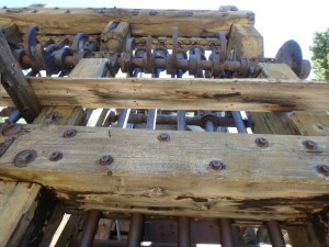
It wasn't long before the GPS told us we were approaching the parking area for the Champion Mill. We all pulled in and found places to park our Jeeps. Walt had the hiking track downloaded on his GPS, so he brought it along to help us find our way. We strayed a little off track but found our way back quickly to get to the mill. It was a short hike and well worth it to see this well-preserved stamp mill. The group took lots of pictures and explored the entire area before hiking back to the Jeeps.

The owners are nice enough to let hikers and mountain bikers use this trail to see their mill, so remember to only take pictures and memories with you when you leave.

We made our way back onto the trail and before we knew it, we were at the Lone Star Mine. There is plenty of space to park and take pictures but it is on private land. Please be respectful of their wishes and don't explore the mine area.

We decided to head the long way out and not take the shortcut back that starts at the Lone Star Mine. The trail gets a little tougher going downhill and the trees and brush rubbed our rigs as we straddled wash outs, but it was great fun.

We finished the trail and wasted no time getting to Rollinsville and the highway to head south to Pickle Gulch.

champion_mill_part_1
champion_mill_part_2
champion_mill_part_3
champion_mill_part_4
champion_mill_part_5
champion_mill_part_6
champion_mill_part_7
champion_mill_part_8
exploring
forest_service_sign
jeeps_at_lone_star_mine
jumbled_mess
lone_star_mine_part_1
lone_star_mine_part_2
lone_star_mine_part_3
lone_star_mine_part_4
metal_and_wood
old_boiler
smooth_trail
trail_sign

Reports from Other Days: 2

Use the arrows or dots to flip through the previews of the other reports for West Magnolia. Click one of them to read more and see all of the photos from that day.

July 1, 2017

Led by Monica I.
Every once in a while we have “one of those days” where it seems like nothing goes as planned.  A few of us camped at the Kelly Dahl campground, and then we all met in Nederland.  We started out with five Jeeps and ended up with only three as two…
»
  • 1
  • 2
Join Us!
If you aren’t a Member or Subscriber, you can’t see all of the content on this site. Get membership information to see why this site is best when you join and log in

Information for Subscribers

When you log in you’ll see more information here:

  • Recent Community Forum posts
  • Recent polls
  • Upcoming Events you can attend
  • Links to online users

© 2000-2023 · TrailDamage.com · Terms and Conditions · About · Contact
Trail information is only accurate on the date posted. Trails may have changed or closed since that date. Use this information for historical purposes only.
Contact the Forest Service or Bureau of Land Management for up-to-date trail information.

/* ----------------------------------------- */ /* View slug: reports-other-reports-for-same-trail-slider - start */ /* ----------------------------------------- */ /* place the prev/next controls on the sides */ .td-transition-controls .wpv-filter-next-link, .td-transition-controls .wpv-filter-previous-link { border: none; font-size: 300%; position: absolute; top: 70px; } .td-transition-controls .wpv-filter-previous-link { left: 0; } .td-transition-controls .wpv-filter-next-link { right: 0; } /* center the page selector horizonatally */ .td-transition-controls ul.wpv_pagination_dots { text-align: center; margin-top: 10px; } /* center the page selector horizonatally */ .td-transition-controls ul.wpv_pagination_dots li.wpv_pagination_dots_item, .td-transition-controls .wpv_pagination_dots li a { display: inline-block; float: none; } /* remove the default styles */ .td-transition-controls .wpv_pagination_dots li a { text-decoration: none; border-bottom: none; } .td-slider-container { padding: 0 25px; margin-bottom: 20px; position: relative; width:100%; display:table; } .td-slides { position: relative; } .td-slides-image { float:left; display:table-cell; } .td-slides-image img { border:1px solid #c0c0c0; } .td-slides-content { padding:4px 4px 4px 10px; border-top:1px solid #c0c0c0; border-right:1px solid #c0c0c0; border-bottom:1px solid #c0c0c0; display:table-cell; height:227px; overflow:hidden; } .td-slides-content h3 { margin-top:8px; } .td-slides-leader { font-size:smaller; margin-top:4px; } /* ----------------------------------------- */ /* View slug: reports-other-reports-for-same-trail-slider - end */ /* ----------------------------------------- */
/* ----------------------------------------- */ /* Content Template: Template for a Single Report - start */ /* ----------------------------------------- */ .entry-header { display:none; } .entry-content h1 { margin-top:16px; padding-top:0; } h1 a { color:#222; } h1 a:hover { color:#666; } p.entry-meta { font-size:small; } #report-body-spacer { clear:both; width:100%; height:20px; } #addtoany-bar { margin-bottom:2em; text-align:center; } .category-reports .post-info .author, .post-info .date { display: none; } .addthis_recommended_horizontal { text-align:center !important; } /* ----------------------------------------- */ /* Content Template: Template for a Single Report - end */ /* ----------------------------------------- */ /* ----------------------------------------- */ /* Content Template: Loop item in REPORTS Runners - start */ /* ----------------------------------------- */ #runners-container { width:100%; clear:both; } .runner { border:1px solid #c0c0c0; margin:0 6px 6px 0; float:left; width:49%; height:81px; } .runner-image { float: left; } .runner-image img { margin:2px 10px 0 2px; height:75px; width:75px; } .runner-name { text-transform:uppercase; } .runner-name a { color:#222; } .runner-name a:hover { color:#666; } .runner-vehicle { font-size:small; } @media only screen and (max-width: 768px) { .runner { width:100%; } } /* ----------------------------------------- */ /* Content Template: Loop item in REPORTS Runners - end */ /* ----------------------------------------- */