TrailDamage.com

Photos, videos and information about 4x4 trails in Colorado and Utah

  • Trails
    • Colorado
    • Utah
  • Reports
    • Featured Photos
    • Featured Videos
    • Reports Calendar
  • Members
  • Search
  • Trail Damage Winners
  • FAQ
  • Community
  • Upcoming Events
  • Membership
  • Log In
  • Facebook
  • Instagram
  • RSS
  • Twitter
  • YouTube

Twin Cone 140621

June 21, 2014 by Monica

Twin Cone

Trail Run on June 21, 2014
Report and photos by Monica I., Trail Leader
View trail information for Twin Cone

Bryan P.
Teal 1993 Jeep Wrangler
Holly P.
Gray 2013 Jeep Wrangler Unlimited Rubicon
Roger R.
Gray 2021 Jeep Wrangler Rubicon 4xe
Austin C.
Khaki 2004 Jeep Wrangler Unlimited Rubicon
Bob S.
Green 1997 Jeep Wrangler
Matt K.
White 2016 Jeep Wrangler Unlimited Rubicon
Pat R.
White 2014 Jeep Wrangler Unlimited Rubicon
Andy S.
Green 2000 Land Rover Discovery Series I
Monica I.
Red 2010 Jeep Wrangler Rubicon
Walt S.
Gray 2022 Jeep Wrangler Unlimited Rubicon 392
Bob R.
Green 2003 Jeep Wrangler Rubicon

One thing that people from outside of the state of Colorado always misjudge is when the wheeling season starts. In Denver, the weather is nice in May so people head up to the mountains. All they find in May above 8,000 feet or so is snow. Even in June there is still a lot of snow in the high country. Twin Cone is a special trail because a lot of it is in the sun, so the snow melts. That means you can get well over 10,000 feet in June near Kenosha Pass.

This trail was always one of our spring "go to" trails, but somehow we forgot about it for a few years. We needed to revisit it, and we were really looking forward to the trip. We had a good-sized group of seasoned wheelers and new members, and it promised to be a great group.

We aired down at the Kenosha Pass pit toilets, of course, and there were quite a few people there. We'd find that there were quite a few vehicles on the trail, too. Everyone we saw was happy and friendly, and that made it fun.

We were going through the residential area near the start, and we were happy to find a nice creek crossing on the trail. It wasn't particularly deep, but it was long and smooth on the bottom, with clean, cold water in it. Monica went through it quickly with her Jeep's top flipped back and windows out, and they got soaked. That's a good way to start the trail.

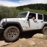
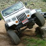
The switchbacks were fun, but we were looking forward to getting to the rocks. We soon found ourselves at the first rocks, and Monica was the only one to get her Jeep's picture taken there. The next bit of rocks was even better, and we all took our turns going through it.

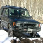
Bob S. was without lockers, and he was gunning it through everything. It was fun to watch. Everyone had a great time in the rocks. Pat's Jeep was three months old, and he made it look easy.

We were already pulled to the side of the trail and it was 1:00, so it was lunch time. We took our time there, even though the mosquitoes were really out. The rain and snow we'd had made everything really green, and the bugs loved it.

Quite a few groups were coming down, and we could see two big groups passing each other high up above timberline. We decided to wait on one of the groups, so we stayed at lunch even longer. There was a break in the traffic, so we started back up.

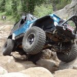
The biggest rocks were even bigger than the last time we were there because of the erosion that had happened during that time. Monica got in the middle of it, but then it was taking too many tries so she backed out of it and went around. Matt tried it a bit, too, but in the end he also had to go around.

Bob S. remembered the line from last time and went high to the left at the edge of the trail. He couldn't lock up his axles, so speed was his friend. He didn't go too fast, but he kept his momentum. He made it through! That was definitely a highlight.

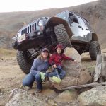
No one else tried the biggest rocks, so we were soon past it. Then another group was coming down, and we were at another wide spot. Everyone was friendly and it was good to see all of the different vehicles.

The last obstacle was always a challenge, but this time it was really big. We all twisted and banged our way through it, though we didn't stop to be the peanut gallery for everyone. We still had a distance to go.

The hill climb was back to its loose and rocky glory. Everyone seemed to take a different line, and they were all fun. Even though no one was in a hurry, we were soon all back together and heading up past Lunch Rock and above timberline.

There was still quite a bit of snow on the peaks around us, but Twin Cone was dry. The rocks above timberline looked the same as before, which was good. Once we got to the top we all parked and got out to wander around.

It was very windy and very chilly, of course. We hung out for a while trying not to blow over and taking lots of pictures. Red Cone was going to have snow on it for quite a while, yet.

We left before we all blew away, and the way down was pretty easy. On the way up, there was someone camping at the overlook so we went by it. Surprisingly, it was open on the way down so we stopped. Holly found one of her control arm mounts bent, and Pat scratched a new rim. Welcome to wheeling!

The overlook is nice, but it isn't as dramatic if you've already been to the top. We stayed for a bit just to enjoy each others' company, but then the mosquitoes were too much. We headed back down to visit at the trailhead instead. It was the perfect day!

above_timberline
adopt-a-trail
airing_down
almost_there
andy_around_the_biggest_rocks
andy_at_the_top
andy_on_the_trail
andy_up_the_hill
aspens
austin_around_the_biggest_rocks
austin_at_the_overlook
austin_at_the_top
austin_up_the_hill
austin_up_the_second_rocks_part_1
austin_up_the_second_rocks_part_2
austin_up_the_second_rocks_part_3
austin_up_the_second_rocks_part_4
austin_up_the_second_rocks_part_5
biggest_rocks
bob_r_around_the_biggest_rocks
bob_r_at_the_top
bob_r_on_the_trail
bob_r_up_the_hill
bob_r_up_the_second_rocks_part_1
bob_r_up_the_second_rocks_part_2
bob_r_up_the_second_rocks_part_3
bob_r_up_the_second_rocks_part_4
bob_r_up_the_second_rocks_part_5
bob_s_and_matt
bob_s_at_the_top
bob_s_he_man
bob_s_in_rocks
bob_s_on_the_trail
bob_s_up_the_biggest_rocks_part_1
bob_s_up_the_biggest_rocks_part_2
bob_s_up_the_biggest_rocks_part_3
bob_s_up_the_biggest_rocks_part_4
bob_s_up_the_hill
bob_s_up_the_second_rocks_part_1
bob_s_up_the_second_rocks_part_2
bob_s_up_the_second_rocks_part_3
bob_s_up_the_second_rocks_part_4
bryan_around_the_biggest_rocks_part_1
bryan_around_the_biggest_rocks_part_2
bryan_at_the_top
bryan_up_the_hill
bryan_up_the_second_rocks_part_1
bryan_up_the_second_rocks_part_2
bryan_up_the_second_rocks_part_3
bryan_up_the_second_rocks_part_4
climbing
deadwood
descent
down_the_hill
early_trail
first_mountain_view
first_rocks
from_the_top
gate_1
holly_around_the_biggest_rocks_part_1
holly_around_the_biggest_rocks_part_2
holly_trail_damage
holly_up_the_hill
holly_up_the_second_rocks_part_1
holly_up_the_second_rocks_part_2
holly_up_the_second_rocks_part_3
holly_up_the_second_rocks_part_4
holly_up_the_second_rocks_part_5
jumble_of_rocks
kenosha_creek_crossing
kenosha_pass_kiosk
last_rock_obstacle
layers
leaning_tree
line_up
lunch_rock_part_1
lunch_rock_part_2
lunch
marsh
matt_and_south_twin_cone
matt_in_aspens
matt_up_the_biggest_rocks_part_1
matt_up_the_biggest_rocks_part_2
matt_up_the_biggest_rocks_part_3
matt_up_the_biggest_rocks_part_4
matt_up_the_second_rocks_part_1
matt_up_the_second_rocks_part_2
matt_up_the_second_rocks_part_3
matt_up_the_second_rocks_part_4
matt_up_the_second_rocks_part_5
monica_and_matt
monica_at_the_overlook
monica_on_the_trail
monica_splash_part_1
monica_splash_part_2
monica_up_the_biggest_rocks_part_1
monica_up_the_biggest_rocks_part_2
monica_up_the_biggest_rocks_part_3
monica_up_the_biggest_rocks_part_4
monica_up_the_biggest_rocks_part_5
monica_up_the_biggest_rocks_part_6
monica_up_the_first_rocks_part_1
monica_up_the_first_rocks_part_2
monica_up_the_first_rocks_part_3
monica_up_the_first_rocks_part_4
monica_up_the_first_rocks_part_5
monica_up_the_first_rocks_part_6
monica_up_the_second_rocks_part_1
monica_up_the_second_rocks_part_2
muddy
nyree_after_the_splash
nyree_at_the_overlook
nyree_at_the_top
obstacle_start
overcast
overlook_part_1
overlook_part_2
overlook_part_3
overlook_part_4
overlook_part_5
overlook_part_6
park
parked_at_the_overlook
parked_at_the_top
pat_and_bob_r
pat_around_the_biggest_rocks_part_1
pat_around_the_biggest_rocks_part_2
pat_around_the_biggest_rocks_part_3
pat_at_the_overlook
pat_trail_damage
pat_up_the_hill_part_1
pat_up_the_hill_part_2
pat_up_the_second_rocks_part_1
pat_up_the_second_rocks_part_2
pat_up_the_second_rocks_part_3
pat_up_the_second_rocks_part_4
pat_up_the_second_rocks_part_5
pat_up_the_second_rocks_part_6
pat_up_the_second_rocks_part_7
pat_up_the_second_rocks_part_8
pond
rock_in_the_trail
rocky_climb
rocky_near_the_top
rocky
roger_around_the_biggest_rocks
roger_at_the_top
roger_up_the_hill
roger_up_the_second_rocks_part_1
roger_up_the_second_rocks_part_2
roger_up_the_second_rocks_part_3
roger_up_the_second_rocks_part_4
saddle
second_rocks_part_1
second_rocks_part_2
snow_near_the_trail
stay_on_the_trail
to_the_top
turn_left
view_at_the_top_part_1
view_at_the_top_part_2
view_at_the_top_part_3
view_at_the_top_part_4
view_at_the_top_part_5
view_at_the_top_part_6
view_at_the_top_part_7
view_at_the_top_part_8
view_at_the_top_part_9
view_from_the_overlook_part_1
view_from_the_overlook_part_2
walt_around_the_biggest_rocks
walt_up_the_second_rocks_part_1
walt_up_the_second_rocks_part_2
walt_up_the_second_rocks_part_3
walt_up_the_second_rocks_part_4
walt_up_the_second_rocks_part_5
windblown_trees

Reports from Other Days: 6

Use the arrows or dots to flip through the previews of the other reports for Twin Cone. Click one of them to read more and see all of the photos from that day.

August 27, 2017

Led by Monica I.
This had to be the first time we went to a trail with some regret. We knew that Twin Cone had drastically changed since we saw it, with a permanent closure in the middle before the obstacles and the big view at the top. We’ve lost some favorite trails over…
»
  • 1
  • 2
  • 3
  • 4
  • 5
  • 6
Join Us!
If you aren’t a Member or Subscriber, you can’t see all of the content on this site. Get membership information to see why this site is best when you join and log in

Information for Subscribers

When you log in you’ll see more information here:

  • Recent Community Forum posts
  • Recent polls
  • Upcoming Events you can attend
  • Links to online users

© 2000-2023 · TrailDamage.com · Terms and Conditions · About · Contact
Trail information is only accurate on the date posted. Trails may have changed or closed since that date. Use this information for historical purposes only.
Contact the Forest Service or Bureau of Land Management for up-to-date trail information.

/* ----------------------------------------- */ /* View slug: reports-other-reports-for-same-trail-slider - start */ /* ----------------------------------------- */ /* place the prev/next controls on the sides */ .td-transition-controls .wpv-filter-next-link, .td-transition-controls .wpv-filter-previous-link { border: none; font-size: 300%; position: absolute; top: 70px; } .td-transition-controls .wpv-filter-previous-link { left: 0; } .td-transition-controls .wpv-filter-next-link { right: 0; } /* center the page selector horizonatally */ .td-transition-controls ul.wpv_pagination_dots { text-align: center; margin-top: 10px; } /* center the page selector horizonatally */ .td-transition-controls ul.wpv_pagination_dots li.wpv_pagination_dots_item, .td-transition-controls .wpv_pagination_dots li a { display: inline-block; float: none; } /* remove the default styles */ .td-transition-controls .wpv_pagination_dots li a { text-decoration: none; border-bottom: none; } .td-slider-container { padding: 0 25px; margin-bottom: 20px; position: relative; width:100%; display:table; } .td-slides { position: relative; } .td-slides-image { float:left; display:table-cell; } .td-slides-image img { border:1px solid #c0c0c0; } .td-slides-content { padding:4px 4px 4px 10px; border-top:1px solid #c0c0c0; border-right:1px solid #c0c0c0; border-bottom:1px solid #c0c0c0; display:table-cell; height:227px; overflow:hidden; } .td-slides-content h3 { margin-top:8px; } .td-slides-leader { font-size:smaller; margin-top:4px; } /* ----------------------------------------- */ /* View slug: reports-other-reports-for-same-trail-slider - end */ /* ----------------------------------------- */
/* ----------------------------------------- */ /* Content Template: Template for a Single Report - start */ /* ----------------------------------------- */ .entry-header { display:none; } .entry-content h1 { margin-top:16px; padding-top:0; } h1 a { color:#222; } h1 a:hover { color:#666; } p.entry-meta { font-size:small; } #report-body-spacer { clear:both; width:100%; height:20px; } #addtoany-bar { margin-bottom:2em; text-align:center; } .category-reports .post-info .author, .post-info .date { display: none; } .addthis_recommended_horizontal { text-align:center !important; } /* ----------------------------------------- */ /* Content Template: Template for a Single Report - end */ /* ----------------------------------------- */ /* ----------------------------------------- */ /* Content Template: Loop item in REPORTS Runners - start */ /* ----------------------------------------- */ #runners-container { width:100%; clear:both; } .runner { border:1px solid #c0c0c0; margin:0 6px 6px 0; float:left; width:49%; height:81px; } .runner-image { float: left; } .runner-image img { margin:2px 10px 0 2px; height:75px; width:75px; } .runner-name { text-transform:uppercase; } .runner-name a { color:#222; } .runner-name a:hover { color:#666; } .runner-vehicle { font-size:small; } @media only screen and (max-width: 768px) { .runner { width:100%; } } /* ----------------------------------------- */ /* Content Template: Loop item in REPORTS Runners - end */ /* ----------------------------------------- */