TrailDamage.com

Photos, videos and information about 4x4 trails in Colorado and Utah

  • Trails
    • Colorado
    • Utah
  • Reports
    • Featured Photos
    • Featured Videos
    • Reports Calendar
  • Members
  • Search
  • Trail Damage Winners
  • FAQ
  • Community
  • Upcoming Events
  • Membership
  • Log In
  • Facebook
  • Instagram
  • RSS
  • Twitter
  • YouTube

T-33A Plane Crash 110702

July 2, 2011 by Monica

T-33A Plane Crash

Trail Run on July 2, 2011
Report and photos by Monica I., Trail Leader
View trail information for T-33A Plane Crash

Katie L.
Blue 2004 Nissan Xterra
Mike S.
Silver 2004 Jeep Wrangler Rubicon
Gary R.
Yellow 1978 Jeep CJ-7
Andrew S.
Brown 2004 Nissan Xterra
Hoa Q.
Black 1995 Land Rover Range Rover
Monica I.
Red 2010 Jeep Wrangler Rubicon

Erosion can really change a trail, and this trail had really changed since we saw it last. Small ledges became big ones and obstacles appeared where it used to be just a bumpy trail. We were expecting the only interesting thing to be at the end when we viewed the crash site but we were wrong. This trail was a lot of fun.

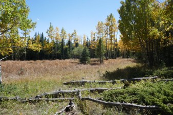
We did Park Creek first and then headed up to the crash site. We did a little bit of the Dead-End Hill just to get to the big view but we didn't go any farther up the hill. It was nice to get out of the trees for a bit so we hung out and enjoyed the scenery for a little while before turning around and heading back down.

This trail was a bit busy and we would see other vehicles and ATVs along the way. The weather was perfect, though, and no one minded waiting.

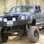
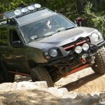
There is a new obstacle with a difficult route down the right side and a very difficult route along the left side. We all went along the right side on the way up.

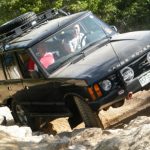
At the ledge we were surprised to find it much more challenging than before. Everyone had a good time testing their vehicles there.

When we got to the crash site hiking trail we parked out of the way as well as we could. A truck was there at the back of the parking area and we found the owners on their way back from the hike. They said they weren't in a hurry so we went do to the hike.

With all of the snow we had everything was so green. It was hard not to fall on the way down to the engine and when we got down there we found a field full of flowers. What a nice surprise! We stayed down there for a bit to enjoy the scenery.

The hike back up was strenuous and slippery. But we all made it back to the parking area. The truck got around us and we followed not long after. We would end up behind them on the way down but it was interesting to watch how different things were in the obstacles with such big trucks.

We had a good time on the way down. Gary tried a different line through the fun obstacle and he was successful. No one had any issues.

When we got back to the trailhead we worked our way to Bunce School Road. We finished that by heading out to the school itself. It was the perfect day.

andrew_in_scenery
andrew_up_a_ledge_part_1
andrew_up_a_ledge_part_2
andrew_up_a_ledge_part_3
andrew_up_a_ledge_part_4
aspens_part_1
aspens_part_2
aspens_part_3
bumpy
cockpit_part_1
cockpit_part_2
dead-end_hill
early_climb
engine_part_1
engine_part_2
gary_up_a_ledge_part_1
gary_up_a_ledge_part_2
gary_up_a_ledge_part_3
gary_up_a_ledge_part_4
hoa_taking_pictures_part_1
hoa_taking_pictures_part_2
hoa_up_a_ledge_part_1
hoa_up_a_ledge_part_2
into_a_meadow
katie_up_a_ledge_part_1
katie_up_a_ledge_part_2
katie_up_a_ledge_part_3
katie_up_a_ledge_part_4
ledges
lonnie_on_a_hike
mike_up_a_ledge_part_1
mike_up_a_ledge_part_2
mike_up_a_ledge_part_3
rocky
through_trees
trailhead
wildflowers

Reports from Other Days: 5

Use the arrows or dots to flip through the previews of the other reports for T-33A Plane Crash. Click one of them to read more and see all of the photos from that day.

September 25, 2016

Led by Monica I.
We were told that the T-33A Plane Crash trail was closed, so we definitely wanted to confirm that. We did Bunce School Road to get there, and then a bit of Park Creek. When we got to the trailhead we were happy to see that it was still open, and…
« »
  • 1
  • 2
  • 3
  • 4
  • 5
Join Us!
If you aren’t a Member or Subscriber, you can’t see all of the content on this site. Get membership information to see why this site is best when you join and log in

Information for Subscribers

When you log in you’ll see more information here:

  • Recent Community Forum posts
  • Recent polls
  • Upcoming Events you can attend
  • Links to online users

© 2000-2023 · TrailDamage.com · Terms and Conditions · About · Contact
Trail information is only accurate on the date posted. Trails may have changed or closed since that date. Use this information for historical purposes only.
Contact the Forest Service or Bureau of Land Management for up-to-date trail information.

/* ----------------------------------------- */ /* View slug: reports-other-reports-for-same-trail-slider - start */ /* ----------------------------------------- */ /* place the prev/next controls on the sides */ .td-transition-controls .wpv-filter-next-link, .td-transition-controls .wpv-filter-previous-link { border: none; font-size: 300%; position: absolute; top: 70px; } .td-transition-controls .wpv-filter-previous-link { left: 0; } .td-transition-controls .wpv-filter-next-link { right: 0; } /* center the page selector horizonatally */ .td-transition-controls ul.wpv_pagination_dots { text-align: center; margin-top: 10px; } /* center the page selector horizonatally */ .td-transition-controls ul.wpv_pagination_dots li.wpv_pagination_dots_item, .td-transition-controls .wpv_pagination_dots li a { display: inline-block; float: none; } /* remove the default styles */ .td-transition-controls .wpv_pagination_dots li a { text-decoration: none; border-bottom: none; } .td-slider-container { padding: 0 25px; margin-bottom: 20px; position: relative; width:100%; display:table; } .td-slides { position: relative; } .td-slides-image { float:left; display:table-cell; } .td-slides-image img { border:1px solid #c0c0c0; } .td-slides-content { padding:4px 4px 4px 10px; border-top:1px solid #c0c0c0; border-right:1px solid #c0c0c0; border-bottom:1px solid #c0c0c0; display:table-cell; height:227px; overflow:hidden; } .td-slides-content h3 { margin-top:8px; } .td-slides-leader { font-size:smaller; margin-top:4px; } /* ----------------------------------------- */ /* View slug: reports-other-reports-for-same-trail-slider - end */ /* ----------------------------------------- */
/* ----------------------------------------- */ /* Content Template: Template for a Single Report - start */ /* ----------------------------------------- */ .entry-header { display:none; } .entry-content h1 { margin-top:16px; padding-top:0; } h1 a { color:#222; } h1 a:hover { color:#666; } p.entry-meta { font-size:small; } #report-body-spacer { clear:both; width:100%; height:20px; } #addtoany-bar { margin-bottom:2em; text-align:center; } .category-reports .post-info .author, .post-info .date { display: none; } .addthis_recommended_horizontal { text-align:center !important; } /* ----------------------------------------- */ /* Content Template: Template for a Single Report - end */ /* ----------------------------------------- */ /* ----------------------------------------- */ /* Content Template: Loop item in REPORTS Runners - start */ /* ----------------------------------------- */ #runners-container { width:100%; clear:both; } .runner { border:1px solid #c0c0c0; margin:0 6px 6px 0; float:left; width:49%; height:81px; } .runner-image { float: left; } .runner-image img { margin:2px 10px 0 2px; height:75px; width:75px; } .runner-name { text-transform:uppercase; } .runner-name a { color:#222; } .runner-name a:hover { color:#666; } .runner-vehicle { font-size:small; } @media only screen and (max-width: 768px) { .runner { width:100%; } } /* ----------------------------------------- */ /* Content Template: Loop item in REPORTS Runners - end */ /* ----------------------------------------- */