TrailDamage.com

Photos, videos and information about 4x4 trails in Colorado and Utah

  • Trails
    • Colorado
    • Utah
  • Reports
    • Featured Photos
    • Featured Videos
    • Reports Calendar
  • Members
  • Search
  • Trail Damage Winners
  • FAQ
  • Community
  • Upcoming Events
  • Membership
  • Log In
  • Facebook
  • Instagram
  • RSS
  • Twitter
  • YouTube

S.O.B. Hill 050827

August 27, 2005 by Monica

S.O.B. Hill

Trail Run on August 27, 2005
Report and photos by Monica I., Trail Leader
View trail information for S.O.B. Hill

Gary R.
Yellow 1978 Jeep CJ-7
Bob S.
Green 1997 Jeep Wrangler
Walt S.
Gray 2018 Jeep Wrangler Unlimited Rubicon
Rob C.
Silver 2003 Jeep Wrangler Rubicon
Bob R.
Green 2003 Jeep Wrangler Rubicon
Monica I.
Red 2010 Jeep Wrangler Rubicon

We ran this trail at the start of a day spent exploring the Swan River trails. It was a blast! The morning was sunny and warm and the hill itself was dry the first time we did it. Then it rained all afternoon and we did it again in the early evening, and it was a completely different experience.

We started off up the Middle Fork of the Swan River and luckily we had the trailhead in the GPS because it would have been hard to find otherwise. There is a fork in the road and the right turn to S.O.B. Hill is marked with a brown Forest Service sign that only has an arrow pointing the way. It wasn't very helpful.

We turned right and found the cabin, then continued on past it. We didn't get too far when we realized that we were supposed to turn right just before the cabin. An ATV driver came by and let us know that the way we were currently going was a dead end not too far into the trail.

We backtracked and decided to check out the cabin while we were there. It was really nice, complete with a loft that had a mattress in it. It was one of the bigger cabins we'd seen that you could actually stay in, and one of the nicest. There was even a little backyard seating area and an old outhouse no longer usable.

We turned onto the correct trail and it was instantly rocky. Around the corner we saw the true obstacle and got out to plan our attack.

Monica went first and got a little hung up on a ledge at first. Then she went a little further and got hung up on another rock. After that it was really rocky but the rocks weren't as loose so it wasn't as difficult.

Gary came next and kept at it, making it look easy. Rob came through then and drove right through it without any issues.

Walt had his Blazer and had the most trouble. The dirt was loose and without lockers or much articulation it was difficult to get over and around all of the rocky sections. We stacked rocks here and there and he made it through to the top part.

The top of S.O.B. Hill has the biggest rocks held firm in the dirt. There is a part with a rock ledge that gave Walt the most trouble of all. With some excellent spotting he got through it, though, and he was to the top.

Bob S. and Bob R. drove through the rocks like it was easy, though they had to give it some momentum in spots. Bob S. even went over a few of the bigger rocks instead of around them like the rest of us did. Jim followed up the back of the group and didn't have any issues even though his Jeep has open differentials. Nice job, everyone!

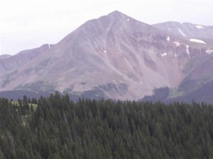
The rest of the climb was beautiful and sunny, taking us through meadows and past old cabins on our way above timberline. After we passed the trees the trail stretched out in front of us, narrow and tippy. We even had some troubles passing some ATVs coming the other way.

When we got to the intersection with Glacier Ridge and Georgia Pass it actually started snowing a little. A lot of the Jeep drivers put their tops up, but it looked like the weather would pass us soon. We went up to the top of Glacier Ridge and had a nice lunch and enjoyed the views, though it was getting chilly.

We went down to Georgia Pass and down the South Fork of the Swan River, and it didn't take very long at all. Then we did the rest of the Swan River trails (see the other report). As we ran the trails the weather got worse, with a lot of rain and snow in the higher elevations. We decided to revisit S.O.B. Hill on our way out.

When we got to the base of the hill it was a different story, with wet rocks and muddy sections. Walt and Jim had left us on another trail, and Bob R. decided to skip S.O.B. Hill this time.

Monica started up first and immediately started slipping and sliding all over. The rocks that were moderate the first time were now all difficult, and the difficult ones were close to impossible. She couldn't make it up the last bit of rocks and had to ask for some rocks to be stacked. The run up was a blast!

Gary went next and had a bit of bad luck, sliding off of one rock directly onto another one, bending his tie rod quite a bit. That didn't stop him from bouncing and sliding his way to the top, though.

Bob S. went next and gave it lots of gas, bouncing his way to the top. He went over some big rocks again and had a great time getting up to the flat spot.

Rob was the last volunteer to try the muddy obstacle, having a few rocks get in his way at the start but otherwise getting up it just fine.

When we got to the top of S.O.B. Hill Gary worked on getting his tie rod straightened out as much as possible. He managed to get it pretty straight but it would still need some work when he got home.

We turned around to go back down S.O.B. Hill where Bob R. was still waiting at the bottom. The trip down was much easier, but you would still slide sideways when you didn't expect it. It would change your line sometimes but it made it more interesting and fun.

When we got to the bottom we went back out and aired up again, then headed off to dinner and story swapping in Frisco. This was a great trail and a great time!

basin
big_view
bob_r_and_jim
bob_r_up_the_hill_part_1
bob_r_up_the_hill_part_2
bob_r_up_the_hill_part_3
bob_s_and_walt
bob_s_up_the_hill_part_1
bob_s_up_the_hill_part_2
bob_s_up_the_hill_part_3
bob_s_up_the_hill_part_4
bob_s_up_the_hill_part_5
bob_s_up_the_hill_part_6
bob_s_up_the_hill_part_7
bob_s_up_the_hill_part_8
cabin_at_the_intersection
cabin_part_1
cabin_part_2
cabin_part_3
cabin_part_4
cabin_part_5
dead_end
gary_and_rob_at_georgia_pass
gary_and_rob
gary_up_the_hill_part_1
gary_up_the_hill_part_2
gary_up_the_hill_part_3
gary_up_the_hill_part_4
gary_up_the_hill_part_5
gary_up_the_hill_part_6
gary_up_the_hill_part_7
georgia_pass
glacier_ridge
intersection_at_the_cabin
intersection_with_glacier_ridge
jim_up_the_hill_part_1
jim_up_the_hill_part_2
jim_up_the_hill_part_3
jim_up_the_hill_part_4
jim_up_the_hill_part_5
jim_up_the_hill_part_6
lunch_part_1
lunch_part_2
lunch_part_3
meadow
monica_up_the_hill_part_1
monica_up_the_hill_part_2
monica_up_the_hill_part_3
monica_up_the_hill_part_4
monica_up_the_hill_part_5
monica_up_the_hill_part_6
mount_guyot
muddy_crossing
old_cabin
open_meadow
outhouse
river_in_the_sun
rob_down_the_hill
rob_up_the_hill_part_1
rob_up_the_hill_part_2
rob_up_the_hill_part_3
s-o-b-_hill_part_1
s-o-b-_hill_part_2
s-o-b-_hill_part_3
s-o-b-_hill_part_4
s-o-b-_hill_part_5
s-o-b-_hill_part_6
s-o-b-_hill_part_7
s-o-b-_hill_part_8
s-o-b-_hill_part_9
sign_marking_the_way_part_1
sign_marking_the_way_part_2
start_of_the_trail
swan_river_crossing
swan_river
to_the_top
trail_above_timberline
trail_in_the_distance
trail_up_glacier_ridge
trailhead_sign
view_from_glacier_ridge
walt_up_the_hill_part_1
walt_up_the_hill_part_2
walt_up_the_hill_part_3
walt_up_the_hill_part_4
walt_up_the_hill_part_5
walt_up_the_hill_part_6
walt_up_the_hill_part_7
walt_up_the_hill_part_8
walt_up_the_hill_part_9
wild_flowers

Reports from Other Days: 3

Use the arrows or dots to flip through the previews of the other reports for S.O.B. Hill. Click one of them to read more and see all of the photos from that day.

July 29, 2006

Led by Dave B.
At the bottom of S.O.B. Hill, we found ourselves behind a full-size Blazer on 35" tires with a rear Detroit locker. After we waited for some ATVs to come down the trail, we watched the Blazer head up the rocks. It reminded us of the Rock Garden on Spring Creek….
«
  • 1
  • 2
  • 3
Join Us!
If you aren’t a Member or Subscriber, you can’t see all of the content on this site. Get membership information to see why this site is best when you join and log in

Information for Subscribers

When you log in you’ll see more information here:

  • Recent Community Forum posts
  • Recent polls
  • Upcoming Events you can attend
  • Links to online users

© 2000-2021 · TrailDamage.com · Terms and Conditions · About · Contact
Trail information is only accurate on the date posted. Trails may have changed or closed since that date. Use this information for historical purposes only.
Contact the Forest Service or Bureau of Land Management for up-to-date trail information.

/* ----------------------------------------- */ /* View slug: reports-other-reports-for-same-trail-slider - start */ /* ----------------------------------------- */ /* place the prev/next controls on the sides */ .td-transition-controls .wpv-filter-next-link, .td-transition-controls .wpv-filter-previous-link { border: none; font-size: 300%; position: absolute; top: 70px; } .td-transition-controls .wpv-filter-previous-link { left: 0; } .td-transition-controls .wpv-filter-next-link { right: 0; } /* center the page selector horizonatally */ .td-transition-controls ul.wpv_pagination_dots { text-align: center; margin-top: 10px; } /* center the page selector horizonatally */ .td-transition-controls ul.wpv_pagination_dots li.wpv_pagination_dots_item, .td-transition-controls .wpv_pagination_dots li a { display: inline-block; float: none; } /* remove the default styles */ .td-transition-controls .wpv_pagination_dots li a { text-decoration: none; border-bottom: none; } .td-slider-container { padding: 0 25px; margin-bottom: 20px; position: relative; width:100%; display:table; } .td-slides { position: relative; } .td-slides-image { float:left; display:table-cell; } .td-slides-image img { border:1px solid #c0c0c0; } .td-slides-content { padding:4px 4px 4px 10px; border-top:1px solid #c0c0c0; border-right:1px solid #c0c0c0; border-bottom:1px solid #c0c0c0; display:table-cell; height:227px; overflow:hidden; } .td-slides-content h3 { margin-top:8px; } .td-slides-leader { font-size:smaller; margin-top:4px; } /* ----------------------------------------- */ /* View slug: reports-other-reports-for-same-trail-slider - end */ /* ----------------------------------------- */
/* ----------------------------------------- */ /* Content Template: Template for a Single Report - start */ /* ----------------------------------------- */ .entry-header { display:none; } .entry-content h1 { margin-top:16px; padding-top:0; } h1 a { color:#222; } h1 a:hover { color:#666; } p.entry-meta { font-size:small; } #report-body-spacer { clear:both; width:100%; height:20px; } #addtoany-bar { margin-bottom:2em; text-align:center; } .category-reports .post-info .author, .post-info .date { display: none; } .addthis_recommended_horizontal { text-align:center !important; } /* ----------------------------------------- */ /* Content Template: Template for a Single Report - end */ /* ----------------------------------------- */ /* ----------------------------------------- */ /* Content Template: Loop item in REPORTS Runners - start */ /* ----------------------------------------- */ #runners-container { width:100%; clear:both; } .runner { border:1px solid #c0c0c0; margin:0 6px 6px 0; float:left; width:49%; height:81px; } .runner-image { float: left; } .runner-image img { margin:2px 10px 0 2px; height:75px; width:75px; } .runner-name { text-transform:uppercase; } .runner-name a { color:#222; } .runner-name a:hover { color:#666; } .runner-vehicle { font-size:small; } @media only screen and (max-width: 768px) { .runner { width:100%; } } /* ----------------------------------------- */ /* Content Template: Loop item in REPORTS Runners - end */ /* ----------------------------------------- */