TrailDamage.com

Photos, videos and information about 4x4 trails in Colorado and Utah

  • Trails
    • Colorado
    • Utah
  • Reports
    • Featured Photos
    • Featured Videos
    • Reports Calendar
  • Members
  • Search
  • Trail Damage Winners
  • FAQ
  • Community
  • Upcoming Events
  • Membership
  • Log In
  • Facebook
  • Instagram
  • RSS
  • Twitter
  • YouTube

Slaughterhouse Gulch 160924

September 24, 2016 by Monica

Slaughterhouse Gulch

Trail Run on September 24, 2016
Report and photos by Monica I., Trail Leader
View trail information for Slaughterhouse Gulch

Mike S.
Silver 2004 Jeep Wrangler Rubicon
Matt K.
White 2016 Jeep Wrangler Unlimited Rubicon
Monica I.
Red 2010 Jeep Wrangler Rubicon
Eric S.
Yellow 2004 Nissan Xterra
Joe C.
Silver 2012 Jeep Wrangler Unlimited Rubicon

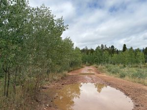
We found snow and very chilly temperatures on Geneva Creek, so we headed over to Slaughterhouse Gulch to stay lower in elevation. That would increase our chances of better weather. We picked the right trail and had fantastic weather for the rest of the day, with almost all of the aspen trees covered in yellow leaves. We even saw a lot of leaves on the trail, making everything really scenic.

We talked about how we used to do Slaughterhouse Gulch all the time, and how it was once one of our favorite trails. It had really changed a lot since our first trip there. Stump Hill and its whoopdeedoos was long closed, and the mud pits were gone. Even Poser Rock wasn't as much of a challenge, so we skipped it. It was a bit of a bummer, seeing how much it had changed, but there were some good changes, too.

We enjoyed the first part of the trail because the scenery was so amazing. When we got to the wide spot at the top of the descent down into the gulch, a vehicle came up from that direction. It was weird, because the trail is usually driven in the counterclockwise route. The driver was running up ahead of a vehicle towing another one, though, and it was out of commission. That made sense, to come up that way. We hung out for a bit and waited, and it didn't take long for them to get up to where we were. Then we headed down.

There were quite a few more people out riding the trail, but everyone was happy to be out and we didn't get in anyone's way. The descent was uneventful, and we didn't find any mud to speak of at the bottom. The big hole was still there, and we were sure it was still filled with muddy water in the spring.

When we got to the open area at the bottom we parked for a bit. We were using the new club camera and we had to do some test shots. Everyone else was wandering through the yellow aspens taking pictures of everything, it seemed. The RC buggies were out and everyone was enjoying the time together.

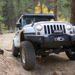
We eventually headed up and out of the gulch. Though that hill used to be difficult, it wasn't much of a challenge for anyone this time. When we got to the top, though, we had a blast. There were big, eroded spots with rocks to enjoy, and we all found our fun there. We got flexy and everyone was smiling.

There was another rocky spot that was good, and the rest of the trail was scenic without any places that caused anyone troubles. That meant we were soon out at the trailhead and airing up.

Monica, Matt, and their passengers decided to check out the Bucksnort Saloon because we finished so early. The restaurant and bar were really cool and we didn't regret the trip out there, but the service and food were pretty bad. Apparently, the local news had mentioned the place as a destination after aspen viewing, and they had been slammed all day. Still, we had a decent time and managed to head for home when it was still pretty early. It was a great day of wheeling.

all_different_colors
around_a_bend
around_trees
aspens_part_1
aspens_part_2
aspens_part_3
aspens_part_4
aspens_part_5
aspens_part_6
aspens_part_7
aspens_part_8
aspens_part_9
between_aspens_and_pines
blue_sky
chunky
climbing
closed_trail
clouds
colorful
covered_in_leaves
curve
dead_end
deer
distant_hills
down_to_the_gulch
downhill_parking
downhill_section
early_trail
easy_climb
fencing
flexy_climb
fun_section
hanging_out
heavy_clouds
hills
intersection_sign
intersection
joe_heading_downhill
joe_on_the_hill_part_1
joe_on_the_hill_part_2
joe_on_the_hill_part_3
joe_on_the_hill_part_4
joe_on_the_hill_part_5
joe_on_the_hill_part_6
joe_on_the_hill_part_7
joe_on_the_hill_part_8
joe_on_the_trail
joe_parked
light_and_shadows
little_bumps
matt_and_joe
matt_on_the_hill_part_1
matt_on_the_hill_part_2
matt_on_the_hill_part_3
matt_on_the_hill_part_4
matt_on_the_hill_part_5
matt_parked
mellow
mike_on_the_hill_part_1
mike_on_the_hill_part_2
mike_on_the_hill_part_3
mike_on_the_hill_part_4
mike_on_the_hill_part_5
mike_on_the_hill_part_6
mike_on_the_hill_part_7
mike_on_the_trail
mike_parked
monica_on_the_hill_part_1
monica_on_the_hill_part_2
monica_on_the_hill_part_3
monica_on_the_hill_part_4
monica_on_the_hill_part_5
monica_on_the_hill_part_6
monica_on_the_hill_part_7
monica_on_the_trail
monica_parked
monica_taking_pictures
mountain_view
muddy_water
muddy
narrow_trees
no_more_mud_pits
nyree_and_monica
nyree_in_the_jeep
nyree_taking_pictures
open_space
parked_at_the_top
parked_in_the_open_space
rocky_climb
rocky
roots
short_climb
starting_downhill
still_climbing
tall_and_skinny
trench_part_1
trench_part_2
uphill_fun
uphill_part_1
uphill_part_2
uphill_part_3
uphill_part_4
uphill_part_5
uphill_part_6
wavy
weaving
whoopdeedoos

Reports from Other Days: 15

Use the arrows or dots to flip through the previews of the other reports for Slaughterhouse Gulch. Click one of them to read more and see all of the photos from that day.

October 2, 2021

Led by Matt K.
Matt waited at the gas station meeting place for 20 minutes, but nobody else showed up for the trail run. Matt knew that Slaughterhouse Gulch is not a hard trail to run, so he decided to go on his own. It looked like it was going to be a very…
»
  • 1
  • 2
  • 3
  • 4
  • 5
  • 6
  • 7
  • 8
  • 9
  • 10
  • 11
  • 12
  • 13
  • 14
  • 15
Join Us!
If you aren’t a Member or Subscriber, you can’t see all of the content on this site. Get membership information to see why this site is best when you join and log in

Information for Subscribers

When you log in you’ll see more information here:

  • Recent Community Forum posts
  • Recent polls
  • Upcoming Events you can attend
  • Links to online users

© 2000-2023 · TrailDamage.com · Terms and Conditions · About · Contact
Trail information is only accurate on the date posted. Trails may have changed or closed since that date. Use this information for historical purposes only.
Contact the Forest Service or Bureau of Land Management for up-to-date trail information.

/* ----------------------------------------- */ /* View slug: reports-other-reports-for-same-trail-slider - start */ /* ----------------------------------------- */ /* place the prev/next controls on the sides */ .td-transition-controls .wpv-filter-next-link, .td-transition-controls .wpv-filter-previous-link { border: none; font-size: 300%; position: absolute; top: 70px; } .td-transition-controls .wpv-filter-previous-link { left: 0; } .td-transition-controls .wpv-filter-next-link { right: 0; } /* center the page selector horizonatally */ .td-transition-controls ul.wpv_pagination_dots { text-align: center; margin-top: 10px; } /* center the page selector horizonatally */ .td-transition-controls ul.wpv_pagination_dots li.wpv_pagination_dots_item, .td-transition-controls .wpv_pagination_dots li a { display: inline-block; float: none; } /* remove the default styles */ .td-transition-controls .wpv_pagination_dots li a { text-decoration: none; border-bottom: none; } .td-slider-container { padding: 0 25px; margin-bottom: 20px; position: relative; width:100%; display:table; } .td-slides { position: relative; } .td-slides-image { float:left; display:table-cell; } .td-slides-image img { border:1px solid #c0c0c0; } .td-slides-content { padding:4px 4px 4px 10px; border-top:1px solid #c0c0c0; border-right:1px solid #c0c0c0; border-bottom:1px solid #c0c0c0; display:table-cell; height:227px; overflow:hidden; } .td-slides-content h3 { margin-top:8px; } .td-slides-leader { font-size:smaller; margin-top:4px; } /* ----------------------------------------- */ /* View slug: reports-other-reports-for-same-trail-slider - end */ /* ----------------------------------------- */
/* ----------------------------------------- */ /* Content Template: Template for a Single Report - start */ /* ----------------------------------------- */ .entry-header { display:none; } .entry-content h1 { margin-top:16px; padding-top:0; } h1 a { color:#222; } h1 a:hover { color:#666; } p.entry-meta { font-size:small; } #report-body-spacer { clear:both; width:100%; height:20px; } #addtoany-bar { margin-bottom:2em; text-align:center; } .category-reports .post-info .author, .post-info .date { display: none; } .addthis_recommended_horizontal { text-align:center !important; } /* ----------------------------------------- */ /* Content Template: Template for a Single Report - end */ /* ----------------------------------------- */ /* ----------------------------------------- */ /* Content Template: Loop item in REPORTS Runners - start */ /* ----------------------------------------- */ #runners-container { width:100%; clear:both; } .runner { border:1px solid #c0c0c0; margin:0 6px 6px 0; float:left; width:49%; height:81px; } .runner-image { float: left; } .runner-image img { margin:2px 10px 0 2px; height:75px; width:75px; } .runner-name { text-transform:uppercase; } .runner-name a { color:#222; } .runner-name a:hover { color:#666; } .runner-vehicle { font-size:small; } @media only screen and (max-width: 768px) { .runner { width:100%; } } /* ----------------------------------------- */ /* Content Template: Loop item in REPORTS Runners - end */ /* ----------------------------------------- */