TrailDamage.com

Photos, videos and information about 4x4 trails in Colorado and Utah

  • Trails
    • Colorado
    • Utah
  • Reports
    • Featured Photos
    • Featured Videos
    • Reports Calendar
  • Members
  • Search
  • Trail Damage Winners
  • FAQ
  • Community
  • Upcoming Events
  • Membership
  • Log In
  • Facebook
  • Instagram
  • RSS
  • Twitter
  • YouTube

Silver Creek 180616

June 16, 2018 by Monica

Silver Creek

Trail Run on June 16, 2018
Report and photos by Monica I., Trail Leader
View trail information for Silver Creek

Mike S.
Silver 2004 Jeep Wrangler Rubicon
Niko K.
Gray 2017 Jeep Wrangler Unlimited

We were staying at the Ranger Lakes Campground nearby, so we had all day to do trails just south of the campground off of Highway 14.  We started with Silver Creek, a trail we'd seen before.  The last time, it was overgrown and crowded in the trees, but this time it was more open.  We thought it might have something to do with more offroading.

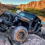
It was a bit overcast at the start of our day, but the temperatures were cool.  There were marshy areas next to the trail, adding to the mosquitoes already around us.  We stopped just before the first creek crossing to put on bug repellent, and Mike stuck the front of his Jeep into the pipe there.  We saw a trail going through it to the other side, but it was too small for a vehicle.  ATVs would have no problem getting through it.

The creek was right near the pipe, and we went through a couple times.  Sometimes we do weird things to get videos and photos of our adventures.

After that creek crossing we went into the trees.  There were quite a few dead trees mixed in with the green ones, but we didn't worry about it too much because everything was soggy from rains.  It made the rocky parts more fun because they were muddy.  There was even a nice spot where the rocks were a bit challenging.

The trail would be a mud puddle followed by rocks, and then back to a mud puddle.  We saw a deer right next to the trail, and then it was back into the mud puddles.  None of them gave us any trouble.

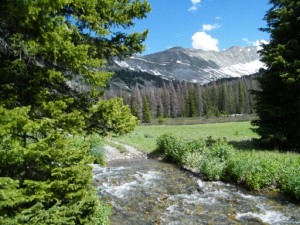
We saw small patches of snow near the trail, but the trail itself was clear already.  We splashed through the second creek crossing and then enjoyed the hill climb of rocks.  Then the trail came out of the trees to run along a gorgeous meadow.  It soon ended at the hiking trail.

We got out to explore, but there were too many mosquitoes to hang out for long.  After a quick reapplication of bug spray, we turned around and headed back out.  On the way down, we saw a moose and her calf, but they were too quick to get with the camera.  We were soon back to the trailhead and off to our next trail.

P1010492
P1010493
P1010494
P1010496
P1010498
P1010499
P1010500
P1010501
P1010503
P1010504
P1010506
P1010507
P1010508
P1010509
P1010510
P1010511
P1010514
P1010515
P1010516
P1010517
P1010518
P1010519
P1010520
P1010522
P1010523
P1010524
P1010526
P1010527
P1010528
P1010529
P1010530
P1010531
P1010532
P1010533
P1010535
P1010536
P1010537
P1010538
P1010539
P1010540
P1010541
P1010542
P1010543
P1010544
P1010545
P1010546
P1010547
P1010548
P1010549
P1010551
P1010552
P1010553
P1010554
P1010555
P1010556
P1010557
P1010558
P1010559
P1010562
P1010563
P1010564
P1010565
P1010566
P1010567
P1010568
P1010569
P1010570
P1010571
P1010572
P1010574
P1010575
P1010576
P1010577
P1010578
P1010579
P1010580
P1010581
P1010582
P1010583
P1010584
P1010585
P1010586
P1010587
P1010588
P1010589
P1010591
P1010592
P1010596
P1010600
P1010601
P1010603
P1010604
P1010605
P1010606

Report from a Different Day

July 15, 2011

Led by Monica I.
We just finished the end of Michigan River and when we got to the major intersection there were some people on dirt bikes replacing the signs that closed Baker Pass. It turned out that they were with the state parks and it was very handy to run into them. Baker…
Join Us!
If you aren’t a Member or Subscriber, you can’t see all of the content on this site. Get membership information to see why this site is best when you join and log in

Information for Subscribers

When you log in you’ll see more information here:

  • Recent Community Forum posts
  • Recent polls
  • Upcoming Events you can attend
  • Links to online users

© 2000-2022 · TrailDamage.com · Terms and Conditions · About · Contact
Trail information is only accurate on the date posted. Trails may have changed or closed since that date. Use this information for historical purposes only.
Contact the Forest Service or Bureau of Land Management for up-to-date trail information.

/* ----------------------------------------- */ /* View slug: reports-other-reports-for-same-trail-slider - start */ /* ----------------------------------------- */ /* place the prev/next controls on the sides */ .td-transition-controls .wpv-filter-next-link, .td-transition-controls .wpv-filter-previous-link { border: none; font-size: 300%; position: absolute; top: 70px; } .td-transition-controls .wpv-filter-previous-link { left: 0; } .td-transition-controls .wpv-filter-next-link { right: 0; } /* center the page selector horizonatally */ .td-transition-controls ul.wpv_pagination_dots { text-align: center; margin-top: 10px; } /* center the page selector horizonatally */ .td-transition-controls ul.wpv_pagination_dots li.wpv_pagination_dots_item, .td-transition-controls .wpv_pagination_dots li a { display: inline-block; float: none; } /* remove the default styles */ .td-transition-controls .wpv_pagination_dots li a { text-decoration: none; border-bottom: none; } .td-slider-container { padding: 0 25px; margin-bottom: 20px; position: relative; width:100%; display:table; } .td-slides { position: relative; } .td-slides-image { float:left; display:table-cell; } .td-slides-image img { border:1px solid #c0c0c0; } .td-slides-content { padding:4px 4px 4px 10px; border-top:1px solid #c0c0c0; border-right:1px solid #c0c0c0; border-bottom:1px solid #c0c0c0; display:table-cell; height:227px; overflow:hidden; } .td-slides-content h3 { margin-top:8px; } .td-slides-leader { font-size:smaller; margin-top:4px; } /* ----------------------------------------- */ /* View slug: reports-other-reports-for-same-trail-slider - end */ /* ----------------------------------------- */
/* ----------------------------------------- */ /* Content Template: Template for a Single Report - start */ /* ----------------------------------------- */ .entry-header { display:none; } .entry-content h1 { margin-top:16px; padding-top:0; } h1 a { color:#222; } h1 a:hover { color:#666; } p.entry-meta { font-size:small; } #report-body-spacer { clear:both; width:100%; height:20px; } #addtoany-bar { margin-bottom:2em; text-align:center; } .category-reports .post-info .author, .post-info .date { display: none; } .addthis_recommended_horizontal { text-align:center !important; } /* ----------------------------------------- */ /* Content Template: Template for a Single Report - end */ /* ----------------------------------------- */ /* ----------------------------------------- */ /* Content Template: Loop item in REPORTS Runners - start */ /* ----------------------------------------- */ #runners-container { width:100%; clear:both; } .runner { border:1px solid #c0c0c0; margin:0 6px 6px 0; float:left; width:49%; height:81px; } .runner-image { float: left; } .runner-image img { margin:2px 10px 0 2px; height:75px; width:75px; } .runner-name { text-transform:uppercase; } .runner-name a { color:#222; } .runner-name a:hover { color:#666; } .runner-vehicle { font-size:small; } @media only screen and (max-width: 768px) { .runner { width:100%; } } /* ----------------------------------------- */ /* Content Template: Loop item in REPORTS Runners - end */ /* ----------------------------------------- */