TrailDamage.com

Photos, videos and information about 4x4 trails in Colorado and Utah

  • Trails
    • Colorado
    • Utah
  • Reports
    • Featured Photos
    • Featured Videos
    • Reports Calendar
  • Members
  • Search
  • Trail Damage Winners
  • FAQ
  • Community
  • Upcoming Events
  • Membership
  • Log In
  • Facebook
  • Google+
  • RSS
  • Twitter
  • YouTube

Schofield Pass 120810

August 10, 2012 by Monica

Schofield Pass

Trail Run on August 10, 2012
Report and photos by Monica I., Trail Leader
View trail information for Schofield Pass

Ben P.
Green 2012 Jeep Wrangler Unlimited Rubicon
Monica I.
Red 2010 Jeep Wrangler Rubicon
Bob S.
Green 1997 Jeep Wrangler
Walt S.
Gold 2004 Jeep Wrangler Rubicon

The last time we were on Schofield Pass was nine years ago to the day. It had been way too long, and we were really looking forward to seeing the trail again. We didn't even have a GPS track for it, so we were on an information-gathering trip, too. We planned on running it in both directions to really enjoy it as much as we could.

We did the easy half of Paradise Divide first, and then we headed into Schofield Pass. The first half is easy, and we had a mellow trip until the signs warning you that it was going to get more difficult.

We stopped at the wooden bridge to take lots of pictures and enjoy the waterfall. The water was freezing so no one waded into it, but we spent a lot of time there. It was so scenic and relaxing, and it was the first time we stopped to relax the entire day. We were in Denver that morning, so we needed a little break. I think we could have happily spent hours there.

But we didn't spend hours there, after all. We avoided the bridge and followed the trail through the water, and kept heading down the trail. It didn't seem like it was very long before we crossed the creek again and found ourselves at the top of the Devil's Punchbowl. We parked there for a bit to enjoy the scenery and check out the first part of the festive section.

We found a few dicey areas and places where you'd need to be careful, but it all looked fine. No one was coming up that we could see, so we headed down.

The worst of the rock obstacles were between the top and the metal bridge. We waited to find the big obstacle that was there nine years ago, but it was gone. We weren't even sure where it used to be. It was sad to find it gone, but it's safer now. There was still a rocky section that kept us on our toes, and it was all fun.

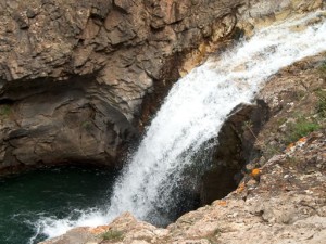
Monica wasn't crazy about the skinny metal bridge, but everyone else enjoyed it. After the bridge we parked in the big parking area and got out to check out the waterfall there. It was really gorgeous, and the water was a deep blue. We stayed there for a bit just enjoying the sounds.

But soon we were off again, and the rest of the Devil's Punchbowl was definitely narrow. There were no places to get around someone, and luckily we didn't see anyone. We made it out of the skinny section and into the trees without any issue.

Soon after that we found ourselves at the three-way intersection. We went out Crystal City and then back in via Lead King Basin. That meant we got to do Schofield Pass in the other direction, too. It seemed to be much easier uphill. We didn't see anyone coming down, and we made quick work of it.

This is such a great trail! We were lucky to plan a trip to Crested Butte when we had such a warm summer. It melted all of the snow, and we had a dry trail. What a blast!

aspens
at_the_metal_bridge
ben_down_devils_punchbowl_part_1
ben_down_devils_punchbowl_part_2
ben_down_devils_punchbowl_part_3
ben_on_the_metal_bridge_part_1
ben_on_the_metal_bridge_part_2
ben_on_the_trail
ben_still_shiny
big_sky
blue_mesa_4-wheelers
bob_at_the_wooden_bridge
bob_down_devils_punchbowl_part_1
bob_down_devils_punchbowl_part_2
bob_on_the_metal_bridge
bob_on_the_trail
brush
clear_water
creek_crossing_at_the_top
curves_in_devils_punchbowl
devils_flower
devils_punchbowl_bottom
devils_punchbowl_in_green
devils_punchbowl_next_to_the_creek
devils_punchbowl_top_part_1
devils_punchbowl_top_part_2
devils_punchbowl_top_part_3
devils_punchbowl_top_part_4
devils_punchbowl_top_part_5
devils_punchbowl_top_part_6
devils_punchbowl_top_part_7
devils_punchbowl_top_part_8
devils_punchbowl_top_part_9
devils_punchbowl
down_devils_punchbowl
driftwood
georgina_and_walt
georgina_happy
greens
little_shelf_road
mellow_at_the_top
metal_bridge_part_1
metal_bridge_part_2
metal_bridge_waterfall_part_1
metal_bridge_waterfall_part_2
metal_bridge_waterfall_part_3
miriam_and_ben
miriam_happy
monica_down_devils_punchbowl
monica_happy
monica_in_scenery
monica_on_the_trail_part_1
monica_on_the_trail_part_2
monica_posing
parked_at_the_top_of_devils_punchbowl
puddle
sign_at_the_trailhead
slope
start_of_the_trail
sunny
tippy
view_from_the_metal_bridge
walt_down_devils_punchbowl
walt_flexing
walt_on_the_metal_bridge_part_1
walt_on_the_metal_bridge_part_2
walt_on_the_trail
warning_signs
west_maroon_trailhead
wooden_bridge_part_1
wooden_bridge_part_2
wooden_bridge_waterfall_part_1
wooden_bridge_waterfall_part_2
wooden_bridge_waterfall_part_3
wooden_bridge_waterfall_part_4
wooden_bridge_waterfall_part_5
wooden_bridge_waterfall_part_6
wooden_bridge_waterfall_part_7
wooden_bridge_waterfall_part_8
wooden_bridge_waterfall_part_9

Report from a Different Day

August 10, 2003

Led by Monica I.
This was one of those trails we’ve all been wanting to do for awhile. It wasn’t nearly as scary as the reports would have you believe, though. The trail has changed considerably over the last few years, making it a lot more mellow than it has been. Apparently there used…
Join Us!
If you aren’t a Member or Subscriber, you can’t see all of the content on this site. Get membership information to see why this site is best when you join and log in

Information for Subscribers

When you log in you’ll see more information here:

  • Recent Community Forum posts
  • Recent polls
  • Upcoming Events you can attend
  • Links to online users

© 2000-2019 · TrailDamage.com · Terms and Conditions · About · Contact
Trail information is only accurate on the date posted. Trails may have changed or closed since that date. Use this information for historical purposes only.
Contact the Forest Service or Bureau of Land Management for up-to-date trail information.

/* ----------------------------------------- */ /* View slug: reports-other-reports-for-same-trail-slider - start */ /* ----------------------------------------- */ /* place the prev/next controls on the sides */ .td-transition-controls .wpv-filter-next-link, .td-transition-controls .wpv-filter-previous-link { border: none; font-size: 300%; position: absolute; top: 70px; } .td-transition-controls .wpv-filter-previous-link { left: 0; } .td-transition-controls .wpv-filter-next-link { right: 0; } /* center the page selector horizonatally */ .td-transition-controls ul.wpv_pagination_dots { text-align: center; margin-top: 10px; } /* center the page selector horizonatally */ .td-transition-controls ul.wpv_pagination_dots li.wpv_pagination_dots_item, .td-transition-controls .wpv_pagination_dots li a { display: inline-block; float: none; } /* remove the default styles */ .td-transition-controls .wpv_pagination_dots li a { text-decoration: none; border-bottom: none; } .td-slider-container { padding: 0 25px; margin-bottom: 20px; position: relative; width:100%; display:table; } .td-slides { position: relative; } .td-slides-image { float:left; display:table-cell; } .td-slides-image img { border:1px solid #c0c0c0; } .td-slides-content { padding:4px 4px 4px 10px; border-top:1px solid #c0c0c0; border-right:1px solid #c0c0c0; border-bottom:1px solid #c0c0c0; display:table-cell; height:227px; overflow:hidden; } .td-slides-content h3 { margin-top:8px; } .td-slides-leader { font-size:smaller; margin-top:4px; } /* ----------------------------------------- */ /* View slug: reports-other-reports-for-same-trail-slider - end */ /* ----------------------------------------- */
/* ----------------------------------------- */ /* Content Template: Template for a Single Report - start */ /* ----------------------------------------- */ .entry-header { display:none; } .entry-content h1 { margin-top:16px; padding-top:0; } h1 a { color:#222; } h1 a:hover { color:#666; } p.entry-meta { font-size:small; } #report-body-spacer { clear:both; width:100%; height:20px; } #addtoany-bar { margin-bottom:2em; text-align:center; } .category-reports .post-info .author, .post-info .date { display: none; } .addthis_recommended_horizontal { text-align:center !important; } /* ----------------------------------------- */ /* Content Template: Template for a Single Report - end */ /* ----------------------------------------- */ /* ----------------------------------------- */ /* Content Template: Loop item in REPORTS Runners - start */ /* ----------------------------------------- */ #runners-container { width:100%; clear:both; } .runner { border:1px solid #c0c0c0; margin:0 6px 6px 0; float:left; width:49%; height:81px; } .runner-image { float: left; } .runner-image img { margin:2px 10px 0 2px; height:75px; width:75px; } .runner-name { text-transform:uppercase; } .runner-name a { color:#222; } .runner-name a:hover { color:#666; } .runner-vehicle { font-size:small; } @media only screen and (max-width: 768px) { .runner { width:100%; } } /* ----------------------------------------- */ /* Content Template: Loop item in REPORTS Runners - end */ /* ----------------------------------------- */