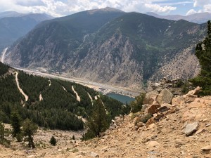
TrailDamage.com

Photos, videos and information about 4x4 trails in Colorado and Utah

  • Trails
    • Colorado
    • Utah
  • Reports
    • Featured Photos
    • Featured Videos
    • Reports Calendar
  • Members
  • Search
  • Trail Damage Winners
  • FAQ
  • Community
  • Upcoming Events
  • Membership
  • Log In
  • Facebook
  • Instagram
  • RSS
  • Twitter
  • YouTube

Saxon Mountain 081115

November 15, 2008 by Monica

Saxon Mountain

Trail Run on November 15, 2008
Report and photos by Monica I., Trail Leader
View trail information for Saxon Mountain

Fred G.
Silver 1983 Jeep CJ-7
Mark G.
Green 1993 Jeep Wrangler
Walt S.
Gray 2022 Jeep Wrangler Unlimited Rubicon 392
Monica I.
Red 2010 Jeep Wrangler Rubicon
Ken G.
Green 1997 Jeep Wrangler
Bob S.
Green 1997 Jeep Wrangler
Bill S.
Yellow 2020 Jeep Wrangler Rubicon
Ryan S.
Red 1999 Jeep Wrangler
Chad S.
Blue 2004 Jeep Wrangler
Brian S.
Blue 1997 Jeep Wrangler

We finished our day with Saxon Mountain, and for many of us it was the first time we had ever been to the top. Normally, we run it after doing Spring Creek and we skip the very top of the mountain. This time, we had time to do it all.

We met with Fred, Mark and Ken as they finished Spring Creek on a run of their own. Then our big group headed up Spring Gulch to the intersection with Saxon Mountain, where we turned left to go up to the top.

We expected more snow, but there really wasn't much even at the top. We all parked and wandered around, enjoying the scenery and each other's company. It was pretty windy and the shadows were getting long, so we finally got in our vehicles and headed down.

Admittedly, we were a bit concerned about what we'd find on the switchbacks on the way down. They were pretty exposed, with death-inducing drop-offs, and it was mid-November. It could be too snowy, or too icy. We proceeded with caution.

There were some icy spots in the shade where previous snows had melted and frozen, but luckily they were in areas where we could safely get across to a more safe section. We worked our way down, hoping for the best.

When we got to the exposed shelf roads, we were happy to find a completely dry trail free of any snow that would cause any concerns. Fantastic! We didn't have any worries the rest of the way down.

What we did have, however, was bumps. And lots of them. It's such a bumpy trail, and not really in a good way. It's no wonder that we only do the trail every once in awhile. It's very scenic and pretty cool with all of its switchbacks, but it really is a bad ride on the way down.

It took a little while, but we were soon down and into Georgetown. We went over to the Visitor Center to air up, which was the perfect place. Everyone was pretty chatty and we stayed awhile, but we left before it was completely dark.

Naturally, we stopped at Beau Jo's. However, it was a long wait for a table of our size, so we walked down to Buffalo Restaurant where we got seated almost right away. It's a good place to eat, and it was a good way to wrap up the 2008 season. We all had a good meal and the company was even better. What a fabulous year we've had!

around_a_bend
bumpy
chad_on_the_trail
close_to_the_top
dusting_of_snow
following_tracks
fred_on_the_trail
highway_view
intersection
jeep_view
ken_on_the_trail
line-up
mark_on_the_trail
mine_shaft
monica_and_bill
mountain_view
no_more_snow
old_cabin
picnic_table_at_the_top
shelf_road
sign_1
sign_2_part_1
sign_2_part_2
sign_2_part_3
switchbacks
trail_with_a_view
view_from_sign_1
view_of_georgetown

Reports from Other Days: 6

Use the arrows or dots to flip through the previews of the other reports for Saxon Mountain. Click one of them to read more and see all of the photos from that day.

September 11, 2021

Led by Matt K.
Saxon Mountain was the second and last trail for the day, and we did it after making it up Spring Creek. We drove to the top of Saxon Mountain before going down to Georgetown. At the top of Saxon Mountain, we all stopped to walk around and enjoy the great…
»
  • 1
  • 2
  • 3
  • 4
  • 5
  • 6
Join Us!
If you aren’t a Member or Subscriber, you can’t see all of the content on this site. Get membership information to see why this site is best when you join and log in

Information for Subscribers

When you log in you’ll see more information here:

  • Recent Community Forum posts
  • Recent polls
  • Upcoming Events you can attend
  • Links to online users

© 2000-2023 · TrailDamage.com · Terms and Conditions · About · Contact
Trail information is only accurate on the date posted. Trails may have changed or closed since that date. Use this information for historical purposes only.
Contact the Forest Service or Bureau of Land Management for up-to-date trail information.

/* ----------------------------------------- */ /* View slug: reports-other-reports-for-same-trail-slider - start */ /* ----------------------------------------- */ /* place the prev/next controls on the sides */ .td-transition-controls .wpv-filter-next-link, .td-transition-controls .wpv-filter-previous-link { border: none; font-size: 300%; position: absolute; top: 70px; } .td-transition-controls .wpv-filter-previous-link { left: 0; } .td-transition-controls .wpv-filter-next-link { right: 0; } /* center the page selector horizonatally */ .td-transition-controls ul.wpv_pagination_dots { text-align: center; margin-top: 10px; } /* center the page selector horizonatally */ .td-transition-controls ul.wpv_pagination_dots li.wpv_pagination_dots_item, .td-transition-controls .wpv_pagination_dots li a { display: inline-block; float: none; } /* remove the default styles */ .td-transition-controls .wpv_pagination_dots li a { text-decoration: none; border-bottom: none; } .td-slider-container { padding: 0 25px; margin-bottom: 20px; position: relative; width:100%; display:table; } .td-slides { position: relative; } .td-slides-image { float:left; display:table-cell; } .td-slides-image img { border:1px solid #c0c0c0; } .td-slides-content { padding:4px 4px 4px 10px; border-top:1px solid #c0c0c0; border-right:1px solid #c0c0c0; border-bottom:1px solid #c0c0c0; display:table-cell; height:227px; overflow:hidden; } .td-slides-content h3 { margin-top:8px; } .td-slides-leader { font-size:smaller; margin-top:4px; } /* ----------------------------------------- */ /* View slug: reports-other-reports-for-same-trail-slider - end */ /* ----------------------------------------- */
/* ----------------------------------------- */ /* Content Template: Template for a Single Report - start */ /* ----------------------------------------- */ .entry-header { display:none; } .entry-content h1 { margin-top:16px; padding-top:0; } h1 a { color:#222; } h1 a:hover { color:#666; } p.entry-meta { font-size:small; } #report-body-spacer { clear:both; width:100%; height:20px; } #addtoany-bar { margin-bottom:2em; text-align:center; } .category-reports .post-info .author, .post-info .date { display: none; } .addthis_recommended_horizontal { text-align:center !important; } /* ----------------------------------------- */ /* Content Template: Template for a Single Report - end */ /* ----------------------------------------- */ /* ----------------------------------------- */ /* Content Template: Loop item in REPORTS Runners - start */ /* ----------------------------------------- */ #runners-container { width:100%; clear:both; } .runner { border:1px solid #c0c0c0; margin:0 6px 6px 0; float:left; width:49%; height:81px; } .runner-image { float: left; } .runner-image img { margin:2px 10px 0 2px; height:75px; width:75px; } .runner-name { text-transform:uppercase; } .runner-name a { color:#222; } .runner-name a:hover { color:#666; } .runner-vehicle { font-size:small; } @media only screen and (max-width: 768px) { .runner { width:100%; } } /* ----------------------------------------- */ /* Content Template: Loop item in REPORTS Runners - end */ /* ----------------------------------------- */