TrailDamage.com

Photos, videos and information about 4x4 trails in Colorado and Utah

  • Trails
    • Colorado
    • Utah
  • Reports
    • Featured Photos
    • Featured Videos
    • Reports Calendar
  • Members
  • Search
  • Trail Damage Winners
  • FAQ
  • Community
  • Upcoming Events
  • Membership
  • Log In
  • Facebook
  • Instagram
  • RSS
  • Twitter
  • YouTube

Santa Fe Peak 090912

September 12, 2009 by Monica

Santa Fe Peak

Trail Run on September 12, 2009
Report and photos by Monica I., Trail Leader
View trail information for Santa Fe Peak

Ladd G.
Green 2003 Jeep Wrangler Rubicon
Bob S.
Green 1997 Jeep Wrangler
Walt S.
Gray 2018 Jeep Wrangler Unlimited Rubicon
Monica I.
Red 2010 Jeep Wrangler Rubicon
Roger R.
White 2005 Jeep Wrangler Unlimited Rubicon
Bob R.
Green 2003 Jeep Wrangler Rubicon
Gary R.
Yellow 1978 Jeep CJ-7

Santa Fe Peak is one of those trails. We tried to run it in 2007 but when we got to the exposed section there was just too much snow. We turned around and headed back down, intending to run it in 2008. But when we got there in 2008 there was even more snow. Now it's 2009 and we've finally seen the trail. Well, sort of.

We found the trail easily enough but it was a few switchbacks in before we found one big enough to park in to air down and disconnect sway bars. It was chilly and sprinkling, but the weather wasn't too bad. Next time we'll air down at the trailhead for Peru Creek where there is lots of room.

We climbed the switchbacks and it was pretty easy. It wasn't long at all before we got to the flat spot where we'd turned around in 2007. The trail was a bit wet but not a big deal. It looked like we were in luck this year.

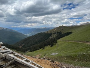
We didn't make any stops at the mine because it was raining. So we climbed and climbed until we got to the flat spot at the top. We stopped for just a bit to take pictures of Montezuma and the valley below us. There was a bit of snow in places, but it didn't look too recent.

As we were there, the rain changed to wet snow. And then it changed to a lot of wet snow. It was even starting to stick on the trail. It was close to a blizzard -- it seemed too early in the year for that kind of weather.

We kept climbing up to the top of Santa Fe Peak and soon the snow was joined by a thick fog. We couldn't see very far, and we talked about whether that made driving on the edge of a cliff more or less intimidating. It's a bit strange when you know you're on the edge of a big drop off but you can't see it.

We got to the top of the peak and Walt was remembering a trip from years ago when he did the trail. He said that there wasn't much to the trail after that. It was really snowing and foggy, and the trail turned into one that didn't look very often used. There were small plants growing in the center of it, but it obviously saw a bit of use. Just not as much as the rest of the trail.

The first few of us continued down to the obvious destination at the mine while the rest waited at the top to hear about what to expect. When Monica and Gary got to the mine, there wasn't much to see and there wasn't much room to turn around. They called on the CB to say that they were coming back up.

Once we were all together again we headed back to the trailhead. It stayed foggy and snowy for a bit, and then we were low enough in elevation that the weather cleared up. By the time we got to Montezuma it was nice again.

We saw the trail but we all knew we had missed out on some amazing scenery. So we already have plans to run it again in a future year when the weather is a bit more cooperative. It's just one of those trails!

airing_down
along_the_shelf_road
bob_r_in_the_snow
down_from_the_top
early_trail
easy_climb
fall_colors
foggy_ahead
healthy_trees
jeeps
limited_visibility
montezuma
patchy_fog
quail_mine_part_1
quail_mine_part_2
shelf_road
snow_bank
starting_to_stick
taking_a_break
to_the_top
trail_after_the_flat_spot
tundra_trail
valley_view
weather_coming

Report from a Different Day

September 24, 2011

Led by Monica I.
We had our fingers crossed and all of the wishing worked because we had fantastic weather. When we first did Santa Fe Peak the fog and clouds were so thick that we didn’t really see much of the scenery around the trail. We were really looking forward to really seeing…
Join Us!
If you aren’t a Member or Subscriber, you can’t see all of the content on this site. Get membership information to see why this site is best when you join and log in

Information for Subscribers

When you log in you’ll see more information here:

  • Recent Community Forum posts
  • Recent polls
  • Upcoming Events you can attend
  • Links to online users

© 2000-2021 · TrailDamage.com · Terms and Conditions · About · Contact
Trail information is only accurate on the date posted. Trails may have changed or closed since that date. Use this information for historical purposes only.
Contact the Forest Service or Bureau of Land Management for up-to-date trail information.

/* ----------------------------------------- */ /* View slug: reports-other-reports-for-same-trail-slider - start */ /* ----------------------------------------- */ /* place the prev/next controls on the sides */ .td-transition-controls .wpv-filter-next-link, .td-transition-controls .wpv-filter-previous-link { border: none; font-size: 300%; position: absolute; top: 70px; } .td-transition-controls .wpv-filter-previous-link { left: 0; } .td-transition-controls .wpv-filter-next-link { right: 0; } /* center the page selector horizonatally */ .td-transition-controls ul.wpv_pagination_dots { text-align: center; margin-top: 10px; } /* center the page selector horizonatally */ .td-transition-controls ul.wpv_pagination_dots li.wpv_pagination_dots_item, .td-transition-controls .wpv_pagination_dots li a { display: inline-block; float: none; } /* remove the default styles */ .td-transition-controls .wpv_pagination_dots li a { text-decoration: none; border-bottom: none; } .td-slider-container { padding: 0 25px; margin-bottom: 20px; position: relative; width:100%; display:table; } .td-slides { position: relative; } .td-slides-image { float:left; display:table-cell; } .td-slides-image img { border:1px solid #c0c0c0; } .td-slides-content { padding:4px 4px 4px 10px; border-top:1px solid #c0c0c0; border-right:1px solid #c0c0c0; border-bottom:1px solid #c0c0c0; display:table-cell; height:227px; overflow:hidden; } .td-slides-content h3 { margin-top:8px; } .td-slides-leader { font-size:smaller; margin-top:4px; } /* ----------------------------------------- */ /* View slug: reports-other-reports-for-same-trail-slider - end */ /* ----------------------------------------- */
/* ----------------------------------------- */ /* Content Template: Template for a Single Report - start */ /* ----------------------------------------- */ .entry-header { display:none; } .entry-content h1 { margin-top:16px; padding-top:0; } h1 a { color:#222; } h1 a:hover { color:#666; } p.entry-meta { font-size:small; } #report-body-spacer { clear:both; width:100%; height:20px; } #addtoany-bar { margin-bottom:2em; text-align:center; } .category-reports .post-info .author, .post-info .date { display: none; } .addthis_recommended_horizontal { text-align:center !important; } /* ----------------------------------------- */ /* Content Template: Template for a Single Report - end */ /* ----------------------------------------- */ /* ----------------------------------------- */ /* Content Template: Loop item in REPORTS Runners - start */ /* ----------------------------------------- */ #runners-container { width:100%; clear:both; } .runner { border:1px solid #c0c0c0; margin:0 6px 6px 0; float:left; width:49%; height:81px; } .runner-image { float: left; } .runner-image img { margin:2px 10px 0 2px; height:75px; width:75px; } .runner-name { text-transform:uppercase; } .runner-name a { color:#222; } .runner-name a:hover { color:#666; } .runner-vehicle { font-size:small; } @media only screen and (max-width: 768px) { .runner { width:100%; } } /* ----------------------------------------- */ /* Content Template: Loop item in REPORTS Runners - end */ /* ----------------------------------------- */