TrailDamage.com

Photos, videos and information about 4x4 trails in Colorado and Utah

  • Trails
    • Colorado
    • Utah
  • Reports
    • Featured Photos
    • Featured Videos
    • Reports Calendar
  • Members
  • Search
  • Trail Damage Winners
  • FAQ
  • Community
  • Upcoming Events
  • Membership
  • Log In
  • Facebook
  • Instagram
  • RSS
  • Twitter
  • YouTube

Rollins Pass East 150801

August 1, 2015 by Monica

Rollins Pass East

Trail Run on August 1, 2015
Report and photos by Monica I., Trail Leader
View trail information for Rollins Pass East

Holly P.
Gray 2013 Jeep Wrangler Unlimited Rubicon
Monica I.
Red 2010 Jeep Wrangler Rubicon
Matt K.
White 2016 Jeep Wrangler Unlimited Rubicon
Julie M.
Green 2012 Jeep Wrangler Unlimited Rubicon

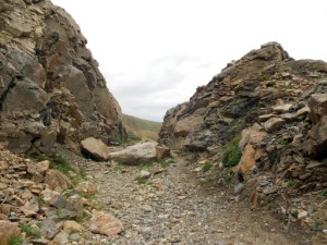
We had seen a lot of cars on the Moffat Tunnel Road, and the trend continued on Rollins Pass East. The summer was winding to a close for kids in public schools, and it looked like everyone was getting out to enjoy one of the last weekends of the season. There were lots of campers as well as day trippers. We started up and ended up behind other vehicles off and on, most of them letting us pass.

We didn't do the mud puddles on the way up, but then we went through them on the way down for some reason. They were nice and smooth on the bottom, as always. Our goal was Jenny Creek, so we turned off and away from the traffic as soon as we got to the trailhead.

After we finished Jenny Creek we found ourselves in a lot of vehicles at Yankee Doodle Lake. We didn't stop, passing slowly through the group and heading up the mountain.

The day was perfect, with big skies and lush greens. There was still a bit of snow next to Yankee Doodle Lake, too. When we got to Jenny Lake, we were surprised to see fewer people than usual, especially because of all of the traffic and people on the way up. We hung out there for a bit enjoying the cooler temperatures and gorgeous scenery.

The trip up to the end of the driveable trail was nice and clear. When we got to the end we parked right next to the gate and got out. Some of us climbed to the top of the hill made by cutting the railroad grade, and we saw hikers all over the place working their ways up and down from the Needle Eye Tunnel. We'd done that hike before and the clouds were rolling in, so we decided to skip it.

We headed down, and it was uneventful the whole way. We stopped at the group campsite to find some people there, but not many. We'd need to camp there as a group sometime. When we got to the end, we headed off to Moffat Tunnel to check things out there. It was a good trip.

around_a_curve
big_view
boulder_wagon_road
cornice
cut_through_rock
cut
dip_duh
early_trees
early_views
easy_climb
end_of_the_line
end_up_ahead
forest
getting_a_better_view
greens
holly_at_jenny_lake
julie_and_holly
julie_at_jenny_lake
julie_at_the_top
lake_from_above
layers
little_bumps
lush
matt_at_jenny_lake
melting
moffat_tunnel
monica_at_jenny_lake
mountain_view
narrow_near_the_tunnel
puddle
railroad_grade
road_closed
rock_pile
rocks_to_the_side
rocky_mountains
rollins_pass_and_boulder_wagon_road
runoff
see_for_miles
shelf_road
snow_next_to_the_trail
snow
start_of_the_trail
straight
through_the_trees
timberline
to_the_tunnel
trail_below
tunnel_closed
upper_shelf_road
valley_below
view_from_near_the_top
yankee_doodle_lake_part_1
yankee_doodle_lake_part_2
yankee_doodle_lake_part_3
yankee_doodle_lake_part_4
yankee_doodle_lake_part_5

Reports from Other Days: 7

Use the arrows or dots to flip through the previews of the other reports for Rollins Pass East. Click one of them to read more and see all of the photos from that day.

July 14, 2012

Led by Monica I.
After doing most of the Moffat Tunnel Road we headed up Rollins Pass East. It was a Saturday, so there was traffic. We didn’t see much on the way up, but we saw a lot on the way down. The weather was still fantastic on the way up, though, so…
»
  • 1
  • 2
  • 3
  • 4
  • 5
  • 6
  • 7
Join Us!
If you aren’t a Member or Subscriber, you can’t see all of the content on this site. Get membership information to see why this site is best when you join and log in

Information for Subscribers

When you log in you’ll see more information here:

  • Recent Community Forum posts
  • Recent polls
  • Upcoming Events you can attend
  • Links to online users

© 2000-2023 · TrailDamage.com · Terms and Conditions · About · Contact
Trail information is only accurate on the date posted. Trails may have changed or closed since that date. Use this information for historical purposes only.
Contact the Forest Service or Bureau of Land Management for up-to-date trail information.

/* ----------------------------------------- */ /* View slug: reports-other-reports-for-same-trail-slider - start */ /* ----------------------------------------- */ /* place the prev/next controls on the sides */ .td-transition-controls .wpv-filter-next-link, .td-transition-controls .wpv-filter-previous-link { border: none; font-size: 300%; position: absolute; top: 70px; } .td-transition-controls .wpv-filter-previous-link { left: 0; } .td-transition-controls .wpv-filter-next-link { right: 0; } /* center the page selector horizonatally */ .td-transition-controls ul.wpv_pagination_dots { text-align: center; margin-top: 10px; } /* center the page selector horizonatally */ .td-transition-controls ul.wpv_pagination_dots li.wpv_pagination_dots_item, .td-transition-controls .wpv_pagination_dots li a { display: inline-block; float: none; } /* remove the default styles */ .td-transition-controls .wpv_pagination_dots li a { text-decoration: none; border-bottom: none; } .td-slider-container { padding: 0 25px; margin-bottom: 20px; position: relative; width:100%; display:table; } .td-slides { position: relative; } .td-slides-image { float:left; display:table-cell; } .td-slides-image img { border:1px solid #c0c0c0; } .td-slides-content { padding:4px 4px 4px 10px; border-top:1px solid #c0c0c0; border-right:1px solid #c0c0c0; border-bottom:1px solid #c0c0c0; display:table-cell; height:227px; overflow:hidden; } .td-slides-content h3 { margin-top:8px; } .td-slides-leader { font-size:smaller; margin-top:4px; } /* ----------------------------------------- */ /* View slug: reports-other-reports-for-same-trail-slider - end */ /* ----------------------------------------- */
/* ----------------------------------------- */ /* Content Template: Template for a Single Report - start */ /* ----------------------------------------- */ .entry-header { display:none; } .entry-content h1 { margin-top:16px; padding-top:0; } h1 a { color:#222; } h1 a:hover { color:#666; } p.entry-meta { font-size:small; } #report-body-spacer { clear:both; width:100%; height:20px; } #addtoany-bar { margin-bottom:2em; text-align:center; } .category-reports .post-info .author, .post-info .date { display: none; } .addthis_recommended_horizontal { text-align:center !important; } /* ----------------------------------------- */ /* Content Template: Template for a Single Report - end */ /* ----------------------------------------- */ /* ----------------------------------------- */ /* Content Template: Loop item in REPORTS Runners - start */ /* ----------------------------------------- */ #runners-container { width:100%; clear:both; } .runner { border:1px solid #c0c0c0; margin:0 6px 6px 0; float:left; width:49%; height:81px; } .runner-image { float: left; } .runner-image img { margin:2px 10px 0 2px; height:75px; width:75px; } .runner-name { text-transform:uppercase; } .runner-name a { color:#222; } .runner-name a:hover { color:#666; } .runner-vehicle { font-size:small; } @media only screen and (max-width: 768px) { .runner { width:100%; } } /* ----------------------------------------- */ /* Content Template: Loop item in REPORTS Runners - end */ /* ----------------------------------------- */