TrailDamage.com

Photos, videos and information about 4x4 trails in Colorado and Utah

  • Trails
    • Colorado
    • Utah
  • Reports
    • Featured Photos
    • Featured Videos
    • Reports Calendar
  • Members
  • Search
  • Trail Damage Winners
  • FAQ
  • Community
  • Upcoming Events
  • Membership
  • Log In
  • Facebook
  • Instagram
  • RSS
  • Twitter
  • YouTube

Rollins Pass East 120714

July 14, 2012 by Monica

Rollins Pass East

Trail Run on July 14, 2012
Report and photos by Monica I., Trail Leader
View trail information for Rollins Pass East

Monica I.
Red 2010 Jeep Wrangler Rubicon
Roger R.
Gray 2021 Jeep Wrangler Rubicon 4xe
Walt S.
Gray 2022 Jeep Wrangler Unlimited Rubicon 392

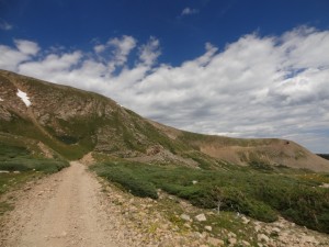
After doing most of the Moffat Tunnel Road we headed up Rollins Pass East. It was a Saturday, so there was traffic. We didn't see much on the way up, but we saw a lot on the way down. The weather was still fantastic on the way up, though, so the scenery was inspiring. We took time to check out the valley below us at every opportunity.

It's such a bumpy road, though, and sometimes it's not very fun. We were passed by someone on a bicycle, and then later we passed her. We drove slowly through the mud puddle, though we fondly remembered flying through it in the past.

We stopped for a break at the campsite parking area just before Jenny Creek so we could stretch our legs. It was starting to get cloudy but it didn't look like rain yet. We did Jenny Creek to get to Yankee Doodle Lake, and it rained on us there. It never really cleared up again.

There were lots of people near the top. A few were fishing at Yankee Doodle Lake, and it didn't have any ice on it. There was a bit of snow above the lake, draining water into it. There were wild flowers all around, and everything was very green. It was one of the most scenic times we've had there.

There was no snow anywhere near the trail all the way to the top. We stopped at Jenny Lake for a snack and there were people camping all over the place. It definitely didn't feel like a quiet getaway in the mountains. The place was packed.

We kept going, passing a full parking area near the hiking trail. When we got to the end of the 4x4 trail there were a couple of cars. We had seen people hiking to the Needle Eye Tunnel, but it wasn't in our schedule for this trip. It had been raining, and it was getting late. We got out for a bit, but then headed back down.

There was a lot of slow-moving traffic on the way down, so we took our time. It didn't rain, so it was nice. It sure is a bumpy trail! Still, it made for a great time in the mountains.

around_a_bend
basin
bumpy_cliff_edge
car_off_the_cliff_part_1
car_off_the_cliff_part_2
clouds
continental_divide
curve
dip_duh
early_climb
easy_section
end_of_the_4x4_trail_part_1
end_of_the_4x4_trail_part_2
forest_lakes_trail_sign
gentle_curve
green_hillside
karen_at_jenny_lake
kiosk
little_rocks
lush
mind_the_width
moffat_tunnel
monica_on_the_trail
needle_eye_tunnel
parked_at_jenny_lake
puddle
railroad_bed
rock_face
roger_at_the_end
roger_on_the_trail
roger_through_the_puddle
rolling_hills
snow_above_yankee_doodle_lake
start_of_the_trail
switchback_climb
timberline
tippy
tolland
trail_after_the_parking_area
up_and_over
valley_view
walt_at_the_end
walt_on_the_trail
walt_through_the_puddle
yankee_doodle_lake_part_1
yankee_doodle_lake_part_2
yankee_doodle_lake_part_3

Reports from Other Days: 7

Use the arrows or dots to flip through the previews of the other reports for Rollins Pass East. Click one of them to read more and see all of the photos from that day.

August 1, 2015

Led by Monica I.
We had seen a lot of cars on the Moffat Tunnel Road, and the trend continued on Rollins Pass East. The summer was winding to a close for kids in public schools, and it looked like everyone was getting out to enjoy one of the last weekends of the season….
»
  • 1
  • 2
  • 3
  • 4
  • 5
  • 6
  • 7
Join Us!
If you aren’t a Member or Subscriber, you can’t see all of the content on this site. Get membership information to see why this site is best when you join and log in

Information for Subscribers

When you log in you’ll see more information here:

  • Recent Community Forum posts
  • Recent polls
  • Upcoming Events you can attend
  • Links to online users

© 2000-2023 · TrailDamage.com · Terms and Conditions · About · Contact
Trail information is only accurate on the date posted. Trails may have changed or closed since that date. Use this information for historical purposes only.
Contact the Forest Service or Bureau of Land Management for up-to-date trail information.

/* ----------------------------------------- */ /* View slug: reports-other-reports-for-same-trail-slider - start */ /* ----------------------------------------- */ /* place the prev/next controls on the sides */ .td-transition-controls .wpv-filter-next-link, .td-transition-controls .wpv-filter-previous-link { border: none; font-size: 300%; position: absolute; top: 70px; } .td-transition-controls .wpv-filter-previous-link { left: 0; } .td-transition-controls .wpv-filter-next-link { right: 0; } /* center the page selector horizonatally */ .td-transition-controls ul.wpv_pagination_dots { text-align: center; margin-top: 10px; } /* center the page selector horizonatally */ .td-transition-controls ul.wpv_pagination_dots li.wpv_pagination_dots_item, .td-transition-controls .wpv_pagination_dots li a { display: inline-block; float: none; } /* remove the default styles */ .td-transition-controls .wpv_pagination_dots li a { text-decoration: none; border-bottom: none; } .td-slider-container { padding: 0 25px; margin-bottom: 20px; position: relative; width:100%; display:table; } .td-slides { position: relative; } .td-slides-image { float:left; display:table-cell; } .td-slides-image img { border:1px solid #c0c0c0; } .td-slides-content { padding:4px 4px 4px 10px; border-top:1px solid #c0c0c0; border-right:1px solid #c0c0c0; border-bottom:1px solid #c0c0c0; display:table-cell; height:227px; overflow:hidden; } .td-slides-content h3 { margin-top:8px; } .td-slides-leader { font-size:smaller; margin-top:4px; } /* ----------------------------------------- */ /* View slug: reports-other-reports-for-same-trail-slider - end */ /* ----------------------------------------- */
/* ----------------------------------------- */ /* Content Template: Template for a Single Report - start */ /* ----------------------------------------- */ .entry-header { display:none; } .entry-content h1 { margin-top:16px; padding-top:0; } h1 a { color:#222; } h1 a:hover { color:#666; } p.entry-meta { font-size:small; } #report-body-spacer { clear:both; width:100%; height:20px; } #addtoany-bar { margin-bottom:2em; text-align:center; } .category-reports .post-info .author, .post-info .date { display: none; } .addthis_recommended_horizontal { text-align:center !important; } /* ----------------------------------------- */ /* Content Template: Template for a Single Report - end */ /* ----------------------------------------- */ /* ----------------------------------------- */ /* Content Template: Loop item in REPORTS Runners - start */ /* ----------------------------------------- */ #runners-container { width:100%; clear:both; } .runner { border:1px solid #c0c0c0; margin:0 6px 6px 0; float:left; width:49%; height:81px; } .runner-image { float: left; } .runner-image img { margin:2px 10px 0 2px; height:75px; width:75px; } .runner-name { text-transform:uppercase; } .runner-name a { color:#222; } .runner-name a:hover { color:#666; } .runner-vehicle { font-size:small; } @media only screen and (max-width: 768px) { .runner { width:100%; } } /* ----------------------------------------- */ /* Content Template: Loop item in REPORTS Runners - end */ /* ----------------------------------------- */