TrailDamage.com

Photos, videos and information about 4x4 trails in Colorado and Utah

  • Trails
    • Colorado
    • Utah
  • Reports
    • Featured Photos
    • Featured Videos
    • Reports Calendar
  • Members
  • Search
  • Trail Damage Winners
  • FAQ
  • Community
  • Upcoming Events
  • Membership
  • Log In
  • Facebook
  • Instagram
  • RSS
  • Twitter
  • YouTube

Rock Creek 080719

July 19, 2008 by Monica

Rock Creek

Trail Run on July 19, 2008
Report and photos by Monica I., Trail Leader
View trail information for Rock Creek

Jed P.
Green 1998 Jeep Wrangler
Walt S.
Gray 2022 Jeep Wrangler Unlimited Rubicon 392
Monica I.
Red 2010 Jeep Wrangler Rubicon
Mike S.
Silver 2004 Jeep Wrangler Rubicon
Roger R.
Gray 2021 Jeep Wrangler Rubicon 4xe
Mike C.
Red 2012 Jeep Wrangler Unlimited Rubicon

We finished our day with Rock Creek, a new trail for us. We had heard that it was a fun one, and it was. It's too bad we didn't find this one years ago!

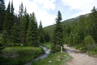
It was easy enough to find, and we got a nice tour of Allenspark. Once we got close to the trailhead, we saw lots of cars parked at the side of the road in many places. As we started the trail, we saw even more cars and people. The trail was easy at this point, and there were lots of people camping.

Though the campsites were all right next to the trail, they were also right next to Rock Creek. It's not a big creek, but it was very pretty. There were lots of nice camp areas set up in the trees, and the trees were thick enough that people weren't camping right on top of each other. Still, you'd be able to hear everyone, even over the sound of the babbling water.

As we kept going, the trail started getting rocky. There were fewer and fewer campers, too. The trail got greener to each side of the bumpy trail, and soon there were no more campers. We were following the creek, still, but it was getting further below us as we climbed.

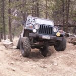
We saw one Jeep full of people on its way down, but otherwise the trail was ours. It was pretty rocky on the way up, but in a fun way. There were even some sections that had some big rocks to climb. It really changed elevation quickly, too.

We thought that the trail would continue to follow the creek, but when we saw that portion of the trail it quickly ended. It hasn't been in use for many, many years. Instead, the trail veered away from the creek and kept heading up the hill.

We figured it had to end at a scenic spot high at the top of a hill or mountain, but we were wrong. It suddenly ended at a sign and a flat spot. There were no rocks, either. It would be a nice place for a shady camp site, but there weren't any views. It was still in the trees.

We hung out for a little bit, but then we headed down. We aired up near the trailhead, and soon we were on our way. A few of us stopped for dinner in Lyons, filthy from the dusty trails and high temperatures. It was a great day of exploring!

bumpy
early_climb
early_trail
follow_116-2
follow_116
fun_stuff
green
lush_part_1
lush_part_2
rock_creek_part_1
rock_creek_part_2
rock_creek_part_3
rocky_hill
small_water_crossing
starting_to_get_bumpy
through_pine_trees
trailhead_signs
view_at_the_top

Reports from Other Days: 3

Use the arrows or dots to flip through the previews of the other reports for Rock Creek. Click one of them to read more and see all of the photos from that day.

June 27, 2020

Led by Monica I.
We came off of a great time on Johnny Park Road to a few miles of pavement to get to Rock Creek.  Johnny Park ended up being more challenging than it was the last time we were there, and Rock Creek ended up being less challenging. Even though coronavirus restrictions…
»
  • 1
  • 2
  • 3
Join Us!
If you aren’t a Member or Subscriber, you can’t see all of the content on this site. Get membership information to see why this site is best when you join and log in

Information for Subscribers

When you log in you’ll see more information here:

  • Recent Community Forum posts
  • Recent polls
  • Upcoming Events you can attend
  • Links to online users

© 2000-2022 · TrailDamage.com · Terms and Conditions · About · Contact
Trail information is only accurate on the date posted. Trails may have changed or closed since that date. Use this information for historical purposes only.
Contact the Forest Service or Bureau of Land Management for up-to-date trail information.

/* ----------------------------------------- */ /* View slug: reports-other-reports-for-same-trail-slider - start */ /* ----------------------------------------- */ /* place the prev/next controls on the sides */ .td-transition-controls .wpv-filter-next-link, .td-transition-controls .wpv-filter-previous-link { border: none; font-size: 300%; position: absolute; top: 70px; } .td-transition-controls .wpv-filter-previous-link { left: 0; } .td-transition-controls .wpv-filter-next-link { right: 0; } /* center the page selector horizonatally */ .td-transition-controls ul.wpv_pagination_dots { text-align: center; margin-top: 10px; } /* center the page selector horizonatally */ .td-transition-controls ul.wpv_pagination_dots li.wpv_pagination_dots_item, .td-transition-controls .wpv_pagination_dots li a { display: inline-block; float: none; } /* remove the default styles */ .td-transition-controls .wpv_pagination_dots li a { text-decoration: none; border-bottom: none; } .td-slider-container { padding: 0 25px; margin-bottom: 20px; position: relative; width:100%; display:table; } .td-slides { position: relative; } .td-slides-image { float:left; display:table-cell; } .td-slides-image img { border:1px solid #c0c0c0; } .td-slides-content { padding:4px 4px 4px 10px; border-top:1px solid #c0c0c0; border-right:1px solid #c0c0c0; border-bottom:1px solid #c0c0c0; display:table-cell; height:227px; overflow:hidden; } .td-slides-content h3 { margin-top:8px; } .td-slides-leader { font-size:smaller; margin-top:4px; } /* ----------------------------------------- */ /* View slug: reports-other-reports-for-same-trail-slider - end */ /* ----------------------------------------- */
/* ----------------------------------------- */ /* Content Template: Template for a Single Report - start */ /* ----------------------------------------- */ .entry-header { display:none; } .entry-content h1 { margin-top:16px; padding-top:0; } h1 a { color:#222; } h1 a:hover { color:#666; } p.entry-meta { font-size:small; } #report-body-spacer { clear:both; width:100%; height:20px; } #addtoany-bar { margin-bottom:2em; text-align:center; } .category-reports .post-info .author, .post-info .date { display: none; } .addthis_recommended_horizontal { text-align:center !important; } /* ----------------------------------------- */ /* Content Template: Template for a Single Report - end */ /* ----------------------------------------- */ /* ----------------------------------------- */ /* Content Template: Loop item in REPORTS Runners - start */ /* ----------------------------------------- */ #runners-container { width:100%; clear:both; } .runner { border:1px solid #c0c0c0; margin:0 6px 6px 0; float:left; width:49%; height:81px; } .runner-image { float: left; } .runner-image img { margin:2px 10px 0 2px; height:75px; width:75px; } .runner-name { text-transform:uppercase; } .runner-name a { color:#222; } .runner-name a:hover { color:#666; } .runner-vehicle { font-size:small; } @media only screen and (max-width: 768px) { .runner { width:100%; } } /* ----------------------------------------- */ /* Content Template: Loop item in REPORTS Runners - end */ /* ----------------------------------------- */