TrailDamage.com

Photos, videos and information about 4x4 trails in Colorado and Utah

  • Trails
    • Colorado
    • Utah
  • Reports
    • Featured Photos
    • Featured Videos
    • Reports Calendar
  • Members
  • Search
  • Trail Damage Winners
  • FAQ
  • Community
  • Upcoming Events
  • Membership
  • Log In
  • Facebook
  • Instagram
  • RSS
  • Twitter
  • YouTube

Red Cone 050820

August 20, 2005 by Monica

Red Cone

Trail Run on August 20, 2005
Report and photos by Monica I., Trail Leader
View trail information for Red Cone

Cheryl W.
Orange 2006 Jeep Wrangler Unlimited Rubicon
Rob C.
Silver 2003 Jeep Wrangler Rubicon
Mike V.
Blue 2000 Jeep Cherokee
Kendall C.
Blue 1988 Suzuki Samurai
Eric B.
Green 2000 Jeep Wrangler
Perry S.
Purple 1994 Ford Explorer
Mark F.
Blue 2002 Jeep Wrangler
Bob R.
Green 2003 Jeep Wrangler Rubicon
Walt S.
Gray 2022 Jeep Wrangler Unlimited Rubicon 392
Monica I.
Red 2010 Jeep Wrangler Rubicon
Gary R.
Yellow 1978 Jeep CJ-7

We started out expecting 22 vehicles so it was nice to see only 11 as we started our day. The weather was beautiful as we turned off the highway. We met Mike V. at the trailhead and we all aired down there and started making our way to the top of Red Cone.

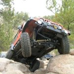
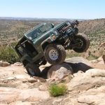
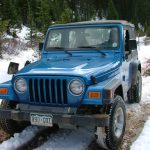
The trail was dry as we climbed the small rocky sections. The sun was out and there were only a few clouds. When we got to the rocky hill with the optional set of big rocks, almost everyone decided to try it.

The rocks are easy to avoid, but it's fun to try them. They are big and stick out enough to make them ledges, with soft dirt below them making it difficult to get traction.

Monica tried it first but couldn't get her front tires over the ledge. She ended up going over it a bit sideways instead. Gary gave it a good try but the dirt was too soft. Some rocks were stacked but it still wasn't enough so he had to go around.

Perry really looked like he was going to make it with his longer wheelbase but there wasn't enough for his tires to grab so he couldn't get up it either.

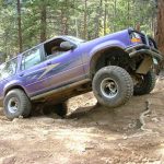
Rob stacked a few more rocks and though they slid away pretty easily he managed to fight his way up and over the rocks -- the first one of the group to make it through. Cheryl and Bob tried to follow Rob's line, stacking the same rocks, but it didn't happen for them.

Mike V. tackled it with his Cherokee and with spinning tires he made it up and through the obstacle without too much trouble. Nice job! Kendall had his big truck with him on this trip so he got a tire up on one of the smaller rocks and called it good.

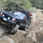
We were all wondering how Kendall's truck would do in the tight switchbacks with whoopdeedoos but he showed us we had nothing to worry about. It's a big truck but it made it through just fine.

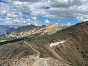
We finally came out of the trees and enjoyed our first view of Red Cone and our trail to the top of it. At this point, a Jeep full of people ran off the trail to get around us, going very fast and being very rude. We tried to get them to stop and get back on the trail but they were going too fast.

Another few Jeeps passed us whenever they could, so we ended up with a few strangers in the middle of our group on the way up. The trail seemed to be full of impatient people wanting to run the trail as fast as possible. On a good note, all of the ATV and motorcycle riders we saw were all very friendly and stayed on the trail (and we saw quite a few).

We watched the trail wrecking Jeep bounce its passengers all over the place and picked up the trash that fell out of it on the way up. Their karma finally caught up with them and they overheated right before getting to the top, blocking the trail for everyone.

We finally got to the top and headed down the first big hill. We were surprised to find it smoothed out all the way down, now with very few rocks on it. It made the trail much easier and safer, but unfortunately it took away the characteristic that made the trail such a memorable one. It was still beautiful, though, so we enjoyed it.

The next two hills were fun as always, and the last one still had its loose rocks, which made it now the scariest one of the three (though it still isn't too bad). When we got to Webster Pass we let the other Jeeps go ahead of us.

We worked our way over to Radical Hill, taking that brief part of Webster Pass that connects it to Red Cone. A few of us went down it fast enough to enjoy the bumps in the trail. It's always a good part! We saw quite a bit of traffic -- mostly ATVs and motorcycles.

We had a very late lunch at our usual spot, though by this point it was pretty chilly and the sun had left us for the day. It was still gorgeous, though. Then after a quick break we headed up to Radical Hill.

Red Cone is always one of our favorites, and even though it's much easier it's probably better now that it's also more safe.

almost_to_the_top
big_drop
big_view
bob_down_red_cone_part_1
bob_down_red_cone_part_2
bob_in_a_tight_turn
bob_on_rocks_part_1
bob_on_rocks_part_2
bob_on_rocks_part_3
bob_on_rocks_part_4
bob_on_the_trail
cheryl_down_red_cone_part_1
cheryl_down_red_cone_part_2
cheryl_on_rocks_part_1
cheryl_on_rocks_part_2
cheryl_on_rocks_part_3
cheryl_on_rocks_part_4
cheryl_on_rocks_part_5
climbing
clouds
colorful
creek
descent
down_from_red_cone
down_from_the_top
early_climb
eric_down_red_cone_part_1
eric_down_red_cone_part_2
eric_in_a_tight_turn
eric_on_the_trail
final_climb
first_descent
first_view_of_red_cone
gary_down_red_cone_part_1
gary_down_red_cone_part_2
gary_down_red_cone_part_3
gary_on_rocks_part_1
gary_on_rocks_part_2
gary_on_rocks_part_3
gary_on_rocks_part_4
gary_on_rocks_part_5
gary_on_the_trail
idiots
kendall_down_red_cone_part_1
kendall_down_red_cone_part_2
kendall_down_red_cone_part_3
kendall_in_a_tight_turn
kendall_on_rocks_part_1
kendall_on_rocks_part_2
kendall_on_the_trail
last_climb
last_hill_down_red_cone
mark_down_red_cone_part_1
mark_down_red_cone_part_2
mark_on_the_trail_part_1
mark_on_the_trail_part_2
mark_on_the_trail_part_3
middle_of_red_cone
mike_down_red_cone_part_1
mike_down_red_cone_part_2
mike_in_a_tight_turn
mike_on_rocks_part_1
mike_on_rocks_part_2
mike_on_rocks_part_3
mike_on_rocks_part_4
mike_on_rocks_part_5
mike_on_rocks_part_6
near_the_top
next_to_the_edge
on_the_trail
perry_down_red_cone_part_1
perry_down_red_cone_part_2
perry_on_rocks_part_1
perry_on_rocks_part_2
perry_on_rocks_part_3
perry_on_rocks_part_4
perry_on_rocks_part_5
perry_on_the_trail
red_cone_colors
red_cone_drop_off
red_cone_in_the_distance
red_cone_in_weather
red_cone_intersection
red_cone_on_the_other_side
red_cone
rob_down_red_cone_part_1
rob_down_red_cone_part_2
rob_on_rocks_part_1
rob_on_rocks_part_2
rob_on_rocks_part_3
rob_on_rocks_part_4
rocky_trail
see_for_miles
sign_at_trailhead
sign_near_the_start
snow
south_park
steepest_part
the_group
timberline
trail_in_the_distance
trailhead
up_the_hill
view_of_radical_hill
waiting_to_go_up_red_cone
walt_down_red_cone_part_1
walt_down_red_cone_part_2
walt_in_a_tight_turn
walt_on_rocks
webster_pass_and_radical_hill
webster_pass_valley
webster_pass

Reports from Other Days: 9

Use the arrows or dots to flip through the previews of the other reports for Red Cone. Click one of them to read more and see all of the photos from that day.

July 30, 2022

Led by Matt K.
Red Cone was the first trail of the day. We aired down at the start of the dirt road for a softer ride down the road. It looked like was going to be a great day with lots of sun, and no thunderstorms were forecasted. The start of the Red…
»
  • 1
  • 2
  • 3
  • 4
  • 5
  • 6
  • 7
  • 8
  • 9
Join Us!
If you aren’t a Member or Subscriber, you can’t see all of the content on this site. Get membership information to see why this site is best when you join and log in

Information for Subscribers

When you log in you’ll see more information here:

  • Recent Community Forum posts
  • Recent polls
  • Upcoming Events you can attend
  • Links to online users

© 2000-2023 · TrailDamage.com · Terms and Conditions · About · Contact
Trail information is only accurate on the date posted. Trails may have changed or closed since that date. Use this information for historical purposes only.
Contact the Forest Service or Bureau of Land Management for up-to-date trail information.

/* ----------------------------------------- */ /* View slug: reports-other-reports-for-same-trail-slider - start */ /* ----------------------------------------- */ /* place the prev/next controls on the sides */ .td-transition-controls .wpv-filter-next-link, .td-transition-controls .wpv-filter-previous-link { border: none; font-size: 300%; position: absolute; top: 70px; } .td-transition-controls .wpv-filter-previous-link { left: 0; } .td-transition-controls .wpv-filter-next-link { right: 0; } /* center the page selector horizonatally */ .td-transition-controls ul.wpv_pagination_dots { text-align: center; margin-top: 10px; } /* center the page selector horizonatally */ .td-transition-controls ul.wpv_pagination_dots li.wpv_pagination_dots_item, .td-transition-controls .wpv_pagination_dots li a { display: inline-block; float: none; } /* remove the default styles */ .td-transition-controls .wpv_pagination_dots li a { text-decoration: none; border-bottom: none; } .td-slider-container { padding: 0 25px; margin-bottom: 20px; position: relative; width:100%; display:table; } .td-slides { position: relative; } .td-slides-image { float:left; display:table-cell; } .td-slides-image img { border:1px solid #c0c0c0; } .td-slides-content { padding:4px 4px 4px 10px; border-top:1px solid #c0c0c0; border-right:1px solid #c0c0c0; border-bottom:1px solid #c0c0c0; display:table-cell; height:227px; overflow:hidden; } .td-slides-content h3 { margin-top:8px; } .td-slides-leader { font-size:smaller; margin-top:4px; } /* ----------------------------------------- */ /* View slug: reports-other-reports-for-same-trail-slider - end */ /* ----------------------------------------- */
/* ----------------------------------------- */ /* Content Template: Template for a Single Report - start */ /* ----------------------------------------- */ .entry-header { display:none; } .entry-content h1 { margin-top:16px; padding-top:0; } h1 a { color:#222; } h1 a:hover { color:#666; } p.entry-meta { font-size:small; } #report-body-spacer { clear:both; width:100%; height:20px; } #addtoany-bar { margin-bottom:2em; text-align:center; } .category-reports .post-info .author, .post-info .date { display: none; } .addthis_recommended_horizontal { text-align:center !important; } /* ----------------------------------------- */ /* Content Template: Template for a Single Report - end */ /* ----------------------------------------- */ /* ----------------------------------------- */ /* Content Template: Loop item in REPORTS Runners - start */ /* ----------------------------------------- */ #runners-container { width:100%; clear:both; } .runner { border:1px solid #c0c0c0; margin:0 6px 6px 0; float:left; width:49%; height:81px; } .runner-image { float: left; } .runner-image img { margin:2px 10px 0 2px; height:75px; width:75px; } .runner-name { text-transform:uppercase; } .runner-name a { color:#222; } .runner-name a:hover { color:#666; } .runner-vehicle { font-size:small; } @media only screen and (max-width: 768px) { .runner { width:100%; } } /* ----------------------------------------- */ /* Content Template: Loop item in REPORTS Runners - end */ /* ----------------------------------------- */