TrailDamage.com

Photos, videos and information about 4x4 trails in Colorado and Utah

  • Trails
    • Colorado
    • Utah
  • Reports
    • Featured Photos
    • Featured Videos
    • Reports Calendar
  • Members
  • Search
  • Trail Damage Winners
  • FAQ
  • Community
  • Upcoming Events
  • Membership
  • Log In
  • Facebook
  • Instagram
  • RSS
  • Twitter
  • YouTube

Red Canyon Ridge 210714

July 14, 2021 by Matt Kuczborski

Red Canyon Ridge

Trail Run on July 14, 2021
Report and photos by Matt K., Trail Leader
View trail information for Red Canyon Ridge

Matt K.
White 2016 Jeep Wrangler Unlimited Rubicon

There was construction at two bridges leading up to the Flaming Gorge dam, and Matt had to wait at one of the traffic lights controlling one-way sections of the road. Corrigan suddenly asked what number the trail had (it is FR 610) and said he saw the tiny white sign with that road number to the right of the road where we were stopped in traffic. Matt would have missed it if it wasn’t for Corrigan spotting the sign! So Matt turned onto the trail and left the construction gridlock.

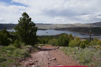
As Matt went up the steep hill at the start of Red Canyon Ridge, it started to rain. Well, drizzle and rain a bit. But we could still take in all the views going up. The trees didn’t form a thick forest. In fact, there were very many signs of previous fires or lightening strikes interspersed all over the area. We were trying to figure it if there had been one big fire or many individual small ones.

After some time, the trail started going downhill towards the northeast, and by this time the sun was starting to come out.

After the downhill section, Matt came up to small heavily treed canyon that had a sign that read the road is closed from August 15th to November 15th for big game protection. The gate was open to vehicles on that day, so Matt continued on. The trail was still around 3.5 miles longer after the gate.

The creek crossing was fun and was overgrown. After the creek crossing, the trail opened up.

The trail did go up and down hills with breaks of open fields. Soon after leaving the creek area, Dorit quipped “HELLO, BIG GAME!!! COME OUT AND LET US SEE YOU!” and just a minute or so later we came upon the first group of many cattle we would see along this area. It was really funny, but of course not the big game we had been hoping to see.

Near the end of Red Canyon Ridge, Matt came up to tree that fell over the trail, blocking it completely, but someone had cleared away a path around the fallen tree and it was clearly visible that vehicles had passed through there, so he continued on.

At the end of the Red Canyon Ridge trail, Matt stopped for lunch. We were right at “Lowline Trail,” a hiking trail going through these hills east to west. On our maps, it looked like Route 610 would stop at least a few hundred yards before the hiking trail, but we drove right up to it before we turned around for the drive back out. We had a great time on the way out, too, for a great day on the trail.

IMG_9271
IMG_9272
IMG_9273
IMG_9274
IMG_9276
IMG_9277
IMG_9278
IMG_9279
IMG_9280
IMG_9281
IMG_9282
IMG_9283
IMG_9284
IMG_9285
IMG_9286
IMG_9287
IMG_9288
IMG_9289
IMG_9290
IMG_9291
IMG_9292
IMG_9293
IMG_9294
IMG_9295
IMG_9296
IMG_9298
IMG_9299
IMG_9300
IMG_9301
IMG_9302
IMG_9303
IMG_9304
IMG_9305
IMG_9306
IMG_9307
IMG_9308
IMG_9309
IMG_9310
IMG_9311
IMG_9312
IMG_9314
IMG_9315
IMG_9316
IMG_9317

Report from a Different Day

May 14, 2018

Led by Monica I.
Sometimes a trail really sneaks up on us, even with the GPS coordinates.  Moonshine Arch jumped out of nowhere that morning, and this time we were really taken by surprise.  We were going slowly along Highway 191 because we knew it was coming up, but still we bunched up at…
Join Us!
If you aren’t a Member or Subscriber, you can’t see all of the content on this site. Get membership information to see why this site is best when you join and log in

Information for Subscribers

When you log in you’ll see more information here:

  • Recent Community Forum posts
  • Recent polls
  • Upcoming Events you can attend
  • Links to online users

© 2000-2022 · TrailDamage.com · Terms and Conditions · About · Contact
Trail information is only accurate on the date posted. Trails may have changed or closed since that date. Use this information for historical purposes only.
Contact the Forest Service or Bureau of Land Management for up-to-date trail information.

/* ----------------------------------------- */ /* View slug: reports-other-reports-for-same-trail-slider - start */ /* ----------------------------------------- */ /* place the prev/next controls on the sides */ .td-transition-controls .wpv-filter-next-link, .td-transition-controls .wpv-filter-previous-link { border: none; font-size: 300%; position: absolute; top: 70px; } .td-transition-controls .wpv-filter-previous-link { left: 0; } .td-transition-controls .wpv-filter-next-link { right: 0; } /* center the page selector horizonatally */ .td-transition-controls ul.wpv_pagination_dots { text-align: center; margin-top: 10px; } /* center the page selector horizonatally */ .td-transition-controls ul.wpv_pagination_dots li.wpv_pagination_dots_item, .td-transition-controls .wpv_pagination_dots li a { display: inline-block; float: none; } /* remove the default styles */ .td-transition-controls .wpv_pagination_dots li a { text-decoration: none; border-bottom: none; } .td-slider-container { padding: 0 25px; margin-bottom: 20px; position: relative; width:100%; display:table; } .td-slides { position: relative; } .td-slides-image { float:left; display:table-cell; } .td-slides-image img { border:1px solid #c0c0c0; } .td-slides-content { padding:4px 4px 4px 10px; border-top:1px solid #c0c0c0; border-right:1px solid #c0c0c0; border-bottom:1px solid #c0c0c0; display:table-cell; height:227px; overflow:hidden; } .td-slides-content h3 { margin-top:8px; } .td-slides-leader { font-size:smaller; margin-top:4px; } /* ----------------------------------------- */ /* View slug: reports-other-reports-for-same-trail-slider - end */ /* ----------------------------------------- */
/* ----------------------------------------- */ /* Content Template: Template for a Single Report - start */ /* ----------------------------------------- */ .entry-header { display:none; } .entry-content h1 { margin-top:16px; padding-top:0; } h1 a { color:#222; } h1 a:hover { color:#666; } p.entry-meta { font-size:small; } #report-body-spacer { clear:both; width:100%; height:20px; } #addtoany-bar { margin-bottom:2em; text-align:center; } .category-reports .post-info .author, .post-info .date { display: none; } .addthis_recommended_horizontal { text-align:center !important; } /* ----------------------------------------- */ /* Content Template: Template for a Single Report - end */ /* ----------------------------------------- */ /* ----------------------------------------- */ /* Content Template: Loop item in REPORTS Runners - start */ /* ----------------------------------------- */ #runners-container { width:100%; clear:both; } .runner { border:1px solid #c0c0c0; margin:0 6px 6px 0; float:left; width:49%; height:81px; } .runner-image { float: left; } .runner-image img { margin:2px 10px 0 2px; height:75px; width:75px; } .runner-name { text-transform:uppercase; } .runner-name a { color:#222; } .runner-name a:hover { color:#666; } .runner-vehicle { font-size:small; } @media only screen and (max-width: 768px) { .runner { width:100%; } } /* ----------------------------------------- */ /* Content Template: Loop item in REPORTS Runners - end */ /* ----------------------------------------- */