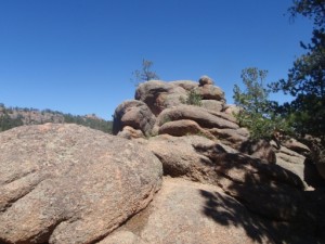
TrailDamage.com

Photos, videos and information about 4x4 trails in Colorado and Utah

  • Trails
    • Colorado
    • Utah
  • Reports
    • Featured Photos
    • Featured Videos
    • Reports Calendar
  • Members
  • Search
  • Trail Damage Winners
  • FAQ
  • Community
  • Upcoming Events
  • Membership
  • Log In
  • Facebook
  • Instagram
  • RSS
  • Twitter
  • YouTube

Rampart Range Road 060902

September 2, 2006 by Monica

Rampart Range Road

Trail Run on September 2, 2006
Report and photos by Monica I., Trail Leader
View trail information for Rampart Range Road

Cheryl W.
Orange 2006 Jeep Wrangler Unlimited Rubicon
Dane R.
Silver 2007 Jeep Wrangler Rubicon
Monica I.
Red 2010 Jeep Wrangler Rubicon
Mike S.
Silver 2004 Jeep Wrangler Rubicon
Jeff L.
Silver 2005 Jeep Wrangler Unlimited Rubicon
Bill S.
Yellow 2020 Jeep Wrangler Rubicon

It was chilly and raining as we worked our way through Sedalia and over to the north end of Rampart Range Road. We had big plans to finish Winding Stairs Road, and there were some mines we were hoping to check out on the way.

We aired down to save us from the massively bumpy washboards of Rampart Range Road. It was a good thing, because the road is definitely bumpy. When we got to the three roads we were hoping to follow to check out mines, we were disappointed to find that only one of them was actually open -- the one to the Little Eddy Mine and the Baldwin Pegmatite Mine.

We went down this little road and soon found a crossroads. We took the right fork first down to the Little Eddy Mine. You can tell that they did a lot of mining there at one point, but there weren't any buildings there that we could see. There were two turnaround areas so we turned around and went to explore the other fork.

The next fork soon came to a campsite that was trashed beyond belief. There were beer cans and bottles everywhere. We had a fairly big group of people, and we broke out the trash bags and got it cleaned up fairly quickly. There is still a big, steel trash can there but we didn't have a big enough vehicle to put it in so we could bring it with us.

Turning around was a bit difficult here, but we got around and back out. Then we headed south on Rampart Range Road some more.

When we got to the trailhead for Winding Stairs Road we turned and headed off on our mission to make it to the end. It was foggy and creepy out, but it kept the dust down. It was a nice, quiet trip.

bill_airing_down
cheryl_airing_down
cheryl_on_the_trail
creepy
curve
dane_airing_down
dane_on_the_trail
don_exploring
donations_welcome
down_to_the_mines_part_1
down_to_the_mines_part_2
down_to_the_mines_part_3
end_at_little_eddy_mine_part_1
end_at_little_eddy_mine_part_2
end_at_little_eddy_mine_part_3
foggy
gate
into_the_trees
jeff_airing_down
jeff_on_the_trail
left_fork_at_the_mines
light_fog
like_pavement
little_eddy_mine
mellow_trail
mellow_upper_trail
mike_airing_down
monica_airing_down
north_end_start
north_end_trailhead
not_like_colorado
really_foggy
sign_at_the_north_end
small_hill

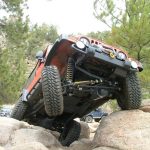
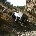
Reports from Other Days: 2

Use the arrows or dots to flip through the previews of the other reports for Rampart Range Road. Click one of them to read more and see all of the photos from that day.

June 12, 2011

Led by Matt K.
It was a nice, warm, sunny day. Matt’s new axle basically blew up in Moab last month and this was his test run with the new, replacement axle. Matt started Rampart Range Road from the south end. When he got to the Garden of the Gods the road was closed…
»
  • 1
  • 2
Join Us!
If you aren’t a Member or Subscriber, you can’t see all of the content on this site. Get membership information to see why this site is best when you join and log in

Information for Subscribers

When you log in you’ll see more information here:

  • Recent Community Forum posts
  • Recent polls
  • Upcoming Events you can attend
  • Links to online users

© 2000-2022 · TrailDamage.com · Terms and Conditions · About · Contact
Trail information is only accurate on the date posted. Trails may have changed or closed since that date. Use this information for historical purposes only.
Contact the Forest Service or Bureau of Land Management for up-to-date trail information.

/* ----------------------------------------- */ /* View slug: reports-other-reports-for-same-trail-slider - start */ /* ----------------------------------------- */ /* place the prev/next controls on the sides */ .td-transition-controls .wpv-filter-next-link, .td-transition-controls .wpv-filter-previous-link { border: none; font-size: 300%; position: absolute; top: 70px; } .td-transition-controls .wpv-filter-previous-link { left: 0; } .td-transition-controls .wpv-filter-next-link { right: 0; } /* center the page selector horizonatally */ .td-transition-controls ul.wpv_pagination_dots { text-align: center; margin-top: 10px; } /* center the page selector horizonatally */ .td-transition-controls ul.wpv_pagination_dots li.wpv_pagination_dots_item, .td-transition-controls .wpv_pagination_dots li a { display: inline-block; float: none; } /* remove the default styles */ .td-transition-controls .wpv_pagination_dots li a { text-decoration: none; border-bottom: none; } .td-slider-container { padding: 0 25px; margin-bottom: 20px; position: relative; width:100%; display:table; } .td-slides { position: relative; } .td-slides-image { float:left; display:table-cell; } .td-slides-image img { border:1px solid #c0c0c0; } .td-slides-content { padding:4px 4px 4px 10px; border-top:1px solid #c0c0c0; border-right:1px solid #c0c0c0; border-bottom:1px solid #c0c0c0; display:table-cell; height:227px; overflow:hidden; } .td-slides-content h3 { margin-top:8px; } .td-slides-leader { font-size:smaller; margin-top:4px; } /* ----------------------------------------- */ /* View slug: reports-other-reports-for-same-trail-slider - end */ /* ----------------------------------------- */
/* ----------------------------------------- */ /* Content Template: Template for a Single Report - start */ /* ----------------------------------------- */ .entry-header { display:none; } .entry-content h1 { margin-top:16px; padding-top:0; } h1 a { color:#222; } h1 a:hover { color:#666; } p.entry-meta { font-size:small; } #report-body-spacer { clear:both; width:100%; height:20px; } #addtoany-bar { margin-bottom:2em; text-align:center; } .category-reports .post-info .author, .post-info .date { display: none; } .addthis_recommended_horizontal { text-align:center !important; } /* ----------------------------------------- */ /* Content Template: Template for a Single Report - end */ /* ----------------------------------------- */ /* ----------------------------------------- */ /* Content Template: Loop item in REPORTS Runners - start */ /* ----------------------------------------- */ #runners-container { width:100%; clear:both; } .runner { border:1px solid #c0c0c0; margin:0 6px 6px 0; float:left; width:49%; height:81px; } .runner-image { float: left; } .runner-image img { margin:2px 10px 0 2px; height:75px; width:75px; } .runner-name { text-transform:uppercase; } .runner-name a { color:#222; } .runner-name a:hover { color:#666; } .runner-vehicle { font-size:small; } @media only screen and (max-width: 768px) { .runner { width:100%; } } /* ----------------------------------------- */ /* Content Template: Loop item in REPORTS Runners - end */ /* ----------------------------------------- */