TrailDamage.com

Photos, videos and information about 4x4 trails in Colorado and Utah

  • Trails
    • Colorado
    • Utah
  • Reports
    • Featured Photos
    • Featured Videos
    • Reports Calendar
  • Members
  • Search
  • Trail Damage Winners
  • FAQ
  • Community
  • Upcoming Events
  • Membership
  • Log In
  • Facebook
  • Instagram
  • RSS
  • Twitter
  • YouTube

Pole Canyon Rim 090523

May 23, 2009 by Monica

Pole Canyon Rim

Trail Run on May 23, 2009
Report and photos by Monica I., Trail Leader
View trail information for Pole Canyon Rim

Mike S.
Silver 2004 Jeep Wrangler Rubicon
Monica I.
Red 2010 Jeep Wrangler Rubicon
Walt S.
Gray 2022 Jeep Wrangler Unlimited Rubicon 392
Jeffrey M.
Khaki 2006 Jeep Wrangler Unlimited Rubicon
Matt K.
White 2016 Jeep Wrangler Unlimited Rubicon
Bill S.
Yellow 2020 Jeep Wrangler Rubicon
Bob S.
Green 1997 Jeep Wrangler

This was our first time on this trail, one that had been on our to-do list for quite awhile. It turned out to be almost the perfect trail -- a mix of fabulous scenery and fun challenges on a short trail very near the pavement. We'll be on this trail again, probably every time we're in the area.

But Pole Canyon Rim wasn't what we had planned for the day. We woke up to more rain, but at least Bill was fixed and with us again. Gary was riding along, and we headed out to do Thompson Canyon and explore the La Sal Mountains a bit.

The closer we got to the mountains the foggier and chillier it got. When we finally got there, we drove a little way in to the trail, slipping and sliding over lots and lots of mud. We parked at the first semi-dry area to have a discussion, and we realized that we could spend all day and not even finish a trail that muddy, and we could easily get ourselves into trouble. After some discussion we decided we'd have to save that trail for another day, so we turned around and went back to the highway.

We figured that the wet weather was also making Onion Creek a muddy mess, so we figured that the area near the Dewey Bridge might be okay. It's more rocky and on higher ground, so it sounded good. We made it to the Dewey Bridge and aired down a bit before lunch time and as the sun was coming out.

We headed out, and Bill announced over the CB that he had lost his Jeep keys. We waited for a bit on the side of the road, but then realized that they were very lost and he needed our help. We all got out and searched for his keys for quite awhile. Then Bill's son, Tom, found the keys in his pocket.

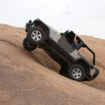
We started going again, and we finally ended up on a trail. It was mostly dry and it started out fun, so it looked like we made a good choice. It was rocky and festive at first, and then we got to the bottom of Pole Vault.

Monica looked up it and decided just to go for it. It was bouncy fun! Everyone else took turns coming up the hill and everyone else enjoyed it. Walt had a bit of difficulty when he got off of his line and forgot he had lockers, but then once he got straightened out it worked out fine.

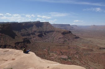
We got up to the top and the 4-way intersection, and then we went straight through it simply because that was the quickest way to an overlook. It was a great place and we stopped for lunch. It provided amazing scenery, even though we were surrounded by powerlines.

Once we were all settled, Gary presented Tom with the "Dumb as a Red Rock Award" for being dumb as a rock. Gary had won it himself many years before for flopping his Jeep over, and it was presented to him by another group of wheelers. Tom took it all in stride. To add to our lunch festivities, Bill made a tinfoil hat for himself.

We had some good laughs, and various people had their keys hidden throughout the day if they weren't watching them. It was definitely the running joke.

We headed back and over to the river overlook where we spent just a bit of time enjoying the view. You could see the traffic below but barely hear it.

We went back to the intersection and explored the last of the trail. It wasn't nearly as scenic or interesting. It also wasn't very long, so it was a short time before we were heading back. We took other spurs on the way back and soon found ourselves at the main road again.

Mike had to head back to town so he left us there. The rest of us headed off to see what else we could find.

big_view
bill_making_a_tin_foil_hat
bill_up_pole_vault_part_1
bill_up_pole_vault_part_2
bob_and_loretta
bob_likes_carrots
bob_muddy
bob_on_the_trail
bob_up_pole_vault_part_1
bob_up_pole_vault_part_2
bob_up_pole_vault_part_3
bumpy
chunky_section
cool_rock
curve_of_steps
early_trail
easy_trail
gary_as_superman
group_at_the_river_overlook
jeeps_on_the_trail
jeffrey_up_pole_vault_part_1
jeffrey_up_pole_vault_part_2
jeffrey_up_pole_vault_part_3
jeffrey_up_pole_vault_part_4
lunch_part_1
lunch_part_2
lunch_part_3
matt_muddy
matt_up_pole_vault
mike_up_pole_vault_part_1
mike_up_pole_vault_part_2
mike_up_pole_vault_part_3
mike_up_pole_vault_part_4
monica_at_the_river_overlook
monica_muddy
pointing_stuff_out
pole_vault
pretty_view
rental_jeeps
river_overlook_part_1
river_overlook_part_2
river_overlook_part_3
river_overlook_part_4
slanted
snowy_mountain_view
straight_track
striped
tom_and_bill
walt_up_pole_vault_part_1
walt_up_pole_vault_part_2
walt_up_pole_vault_part_3
walt_up_pole_vault_part_4

Reports from Other Days: 2

Use the arrows or dots to flip through the previews of the other reports for Pole Canyon Rim. Click one of them to read more and see all of the photos from that day.

May 23, 2020

Led by Monica I.
We weren’t sure our Moab trip was going to work out until what felt like the last minute.  The coronavirus had the town practically closed until just before we got there, and we were happy to find trails open.  The town was filled with people, very few wearing masks, so…
»
  • 1
  • 2
Join Us!
If you aren’t a Member or Subscriber, you can’t see all of the content on this site. Get membership information to see why this site is best when you join and log in

Information for Subscribers

When you log in you’ll see more information here:

  • Recent Community Forum posts
  • Recent polls
  • Upcoming Events you can attend
  • Links to online users

© 2000-2022 · TrailDamage.com · Terms and Conditions · About · Contact
Trail information is only accurate on the date posted. Trails may have changed or closed since that date. Use this information for historical purposes only.
Contact the Forest Service or Bureau of Land Management for up-to-date trail information.

/* ----------------------------------------- */ /* View slug: reports-other-reports-for-same-trail-slider - start */ /* ----------------------------------------- */ /* place the prev/next controls on the sides */ .td-transition-controls .wpv-filter-next-link, .td-transition-controls .wpv-filter-previous-link { border: none; font-size: 300%; position: absolute; top: 70px; } .td-transition-controls .wpv-filter-previous-link { left: 0; } .td-transition-controls .wpv-filter-next-link { right: 0; } /* center the page selector horizonatally */ .td-transition-controls ul.wpv_pagination_dots { text-align: center; margin-top: 10px; } /* center the page selector horizonatally */ .td-transition-controls ul.wpv_pagination_dots li.wpv_pagination_dots_item, .td-transition-controls .wpv_pagination_dots li a { display: inline-block; float: none; } /* remove the default styles */ .td-transition-controls .wpv_pagination_dots li a { text-decoration: none; border-bottom: none; } .td-slider-container { padding: 0 25px; margin-bottom: 20px; position: relative; width:100%; display:table; } .td-slides { position: relative; } .td-slides-image { float:left; display:table-cell; } .td-slides-image img { border:1px solid #c0c0c0; } .td-slides-content { padding:4px 4px 4px 10px; border-top:1px solid #c0c0c0; border-right:1px solid #c0c0c0; border-bottom:1px solid #c0c0c0; display:table-cell; height:227px; overflow:hidden; } .td-slides-content h3 { margin-top:8px; } .td-slides-leader { font-size:smaller; margin-top:4px; } /* ----------------------------------------- */ /* View slug: reports-other-reports-for-same-trail-slider - end */ /* ----------------------------------------- */
/* ----------------------------------------- */ /* Content Template: Template for a Single Report - start */ /* ----------------------------------------- */ .entry-header { display:none; } .entry-content h1 { margin-top:16px; padding-top:0; } h1 a { color:#222; } h1 a:hover { color:#666; } p.entry-meta { font-size:small; } #report-body-spacer { clear:both; width:100%; height:20px; } #addtoany-bar { margin-bottom:2em; text-align:center; } .category-reports .post-info .author, .post-info .date { display: none; } .addthis_recommended_horizontal { text-align:center !important; } /* ----------------------------------------- */ /* Content Template: Template for a Single Report - end */ /* ----------------------------------------- */ /* ----------------------------------------- */ /* Content Template: Loop item in REPORTS Runners - start */ /* ----------------------------------------- */ #runners-container { width:100%; clear:both; } .runner { border:1px solid #c0c0c0; margin:0 6px 6px 0; float:left; width:49%; height:81px; } .runner-image { float: left; } .runner-image img { margin:2px 10px 0 2px; height:75px; width:75px; } .runner-name { text-transform:uppercase; } .runner-name a { color:#222; } .runner-name a:hover { color:#666; } .runner-vehicle { font-size:small; } @media only screen and (max-width: 768px) { .runner { width:100%; } } /* ----------------------------------------- */ /* Content Template: Loop item in REPORTS Runners - end */ /* ----------------------------------------- */