TrailDamage.com

Photos, videos and information about 4x4 trails in Colorado and Utah

  • Trails
    • Colorado
    • Utah
  • Reports
    • Featured Photos
    • Featured Videos
    • Reports Calendar
  • Members
  • Search
  • Trail Damage Winners
  • FAQ
  • Community
  • Upcoming Events
  • Membership
  • Log In
  • Facebook
  • Instagram
  • RSS
  • Twitter
  • YouTube

Peak 10 160730

July 30, 2016 by Monica

Peak 10

Trail Run on July 30, 2016
Report and photos by Monica I., Trail Leader
View trail information for Peak 10

Julie M.
Green 2012 Jeep Wrangler Unlimited Rubicon
Monica I.
Red 2010 Jeep Wrangler Rubicon
Holly P.
Gray 2013 Jeep Wrangler Unlimited Rubicon

Peak 10 is such an interesting trail, because it's basically two trails in one. It starts with an easy trip through the Breckenridge Ski Resort and ends with a steep and rocky climb to the top of a mountain. We enjoyed the whole thing.

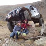
Though we'd been wheeling for 14 years, we never had a "girls run" without any guys driving. Bryan was with us for the first part of the day, but he had to go before we got to Peak 10. That left only female drivers, and it was a fun change.

It was cooling off as the sun started setting, and it was probably going to be cold at the top. As we drove under ski lifts and around padded poles, however, the weather was still nice. We saw quite a few passenger cars and stock trucks filled with people out enjoying the scenery.

We drove past the Overlook Restaurant and didn't see anyone there. It wasn't long after driving by that Monica's "hot oil" warning came on. Her Jeep doesn't enjoy long, slow climbs uphill. We pulled over at the top of the ski lifts to let her Jeep cool off. This is where the trail turns bumpy because the resort doesn't need the road for maintenance anymore. There were cars parked, and people were probably off hiking. We enjoyed the views and put on jackets because we knew it was going to get chilly.

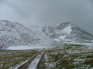
It got windier and colder the higher we climbed. We saw a few bicycles and hikers on their way down as we worked our way up. The first set of switchbacks that took us above timberline were fun.

The long stretch where it is flat was empty. The puddle in the middle of it was actually pretty deep. We took our time going through it.

As we approached the last set of switchbacks we could see the Briar Rose cabin and the weather station high above us. we could also barely see two hikers at the very top of Peak 10.

Those last switchbacks are definitely intimidating, but we had a great time climbing the mountain. Everything is loose and narrow, and the curves are tight. We went up carefully and no one had any issues. When we got to the top, we parked and got out for a long time.

The views were absolutely incredible. We could see Breckenridge below us and Peak 10 next to us. Peak 9 and Father Dyer Peak were on both sides. We took a lot of photos, including of people who were parked on the Crystal Lakes trail to hike to Upper and Lower Crystal Lakes. It was amazingly scenic and we didn't want to leave.

We watched the hikers come down off of Peak 10 and toward us. There was a large patch of snow that they were skiing down on their hiking shoes, and we watched to make sure no one fell. The two hikers were good on their feet, and soon they were down where we were.

We talked to them for a bit, and it turned out they had just hiked the entire range that day. Peak 10 was the end of their hike and they were exhausted. Rather than hiking all the way down the mountain, they rode with us to where the trail got easier, where they parked their own Jeep. It was really interesting to hear their stories.

The trip down the mountain was fairly uneventful, but very scenic right up to the end. We had dinner in Breckenridge before heading for Denver. It was the perfect day.

above_the_resort
above_the_switchbacks
around_a_bend
at_the_weather_station
basin_up_close
between_trees
breckenridge_below
briar_rose_building_part_1
briar_rose_building_part_2
briar_rose_building_part_3
briar_rose_building_part_4
briar_rose_building_part_5
chilly_jeeps
climbing_curve
clouds
cornice
deep_puddle
early_breckenridge_view
early_lift
easy_run
exposed
first_switchback
flat_before_the_switchbacks
forest_hills_drive
getting_rougher
green_ski_runs
group_selfie
happy_hiker
hikers_part_1
hikers_part_2
hikers_part_3
holly_above_timberline
holly_and_her_jeep
holly_and_julie_next_to_the_building
holly_and_julie
holly_and_monica
holly_at_the_top
holly_climbing
holly_on_the_trail
holly_parked_at_the_top
holly_parked
holly_through_the_deep_puddle
jeep_tires
jeeps_at_the_top
jeeps
julie_above_timberline
julie_enjoying_scenery
julie_on_the_trail
julie_parked_at_the_top
julie_parked
julie_up_the_final_switchbacks
lake_below
lift_and_breckenridge
lift_chairs
lift_over_the_road
lift_pole
lift_up_the_hill
longer_shadows
lower_crystal_lake
mellow
mercury_superchair_top
monica_and_julie
monica_and_the_flag
monica_at_the_top
monica_cooling_down
monica_parked_at_the_top
monica_parked
mountain_rocks
near_the_top
needs_snow
next_to_mercury_superchair
open_space
overlook_restaurant
padded_poles
parking_with_a_view
patriotic
peak_8_lift_part_1
peak_8_lift_part_2
peak_9
rain_in_the_distance
rolling_hills
ski_lift_over_grass
ski_scene
ski_sign
snowy_peak
snowy
start_of_the_bumps
start_of_the_trail
sun_setting
taking_a_break
ten_mile_station_intersection
timberline
top_of_the_lift
trail_with_a_view
trailhead_part_1
trailhead_part_2
uphill
upper_crystal_lake
valley
view_from_the_top_part_1
view_from_the_top_part_2
view_from_the_top_part_3
view_from_the_top_part_4
view_from_the_top_part_5
view_from_the_top_part_6
view_from_the_top_part_7
view_from_the_top_part_8
we_made_it
weather_station_flag
weather_station_in_the_distance
weather_station_part_1
weather_station_part_2

Report from a Different Day

August 16, 2008

Led by Monica I.
We were really looking forward to doing this trail. It’s a cool feeling to be on a ski mountain in the summer, surrounded by equipment that is usually reserved for winter. It’s a new way of seeing something you normally see covered in snow. We had a very hard time…
Join Us!
If you aren’t a Member or Subscriber, you can’t see all of the content on this site. Get membership information to see why this site is best when you join and log in

Information for Subscribers

When you log in you’ll see more information here:

  • Recent Community Forum posts
  • Recent polls
  • Upcoming Events you can attend
  • Links to online users

© 2000-2021 · TrailDamage.com · Terms and Conditions · About · Contact
Trail information is only accurate on the date posted. Trails may have changed or closed since that date. Use this information for historical purposes only.
Contact the Forest Service or Bureau of Land Management for up-to-date trail information.

/* ----------------------------------------- */ /* View slug: reports-other-reports-for-same-trail-slider - start */ /* ----------------------------------------- */ /* place the prev/next controls on the sides */ .td-transition-controls .wpv-filter-next-link, .td-transition-controls .wpv-filter-previous-link { border: none; font-size: 300%; position: absolute; top: 70px; } .td-transition-controls .wpv-filter-previous-link { left: 0; } .td-transition-controls .wpv-filter-next-link { right: 0; } /* center the page selector horizonatally */ .td-transition-controls ul.wpv_pagination_dots { text-align: center; margin-top: 10px; } /* center the page selector horizonatally */ .td-transition-controls ul.wpv_pagination_dots li.wpv_pagination_dots_item, .td-transition-controls .wpv_pagination_dots li a { display: inline-block; float: none; } /* remove the default styles */ .td-transition-controls .wpv_pagination_dots li a { text-decoration: none; border-bottom: none; } .td-slider-container { padding: 0 25px; margin-bottom: 20px; position: relative; width:100%; display:table; } .td-slides { position: relative; } .td-slides-image { float:left; display:table-cell; } .td-slides-image img { border:1px solid #c0c0c0; } .td-slides-content { padding:4px 4px 4px 10px; border-top:1px solid #c0c0c0; border-right:1px solid #c0c0c0; border-bottom:1px solid #c0c0c0; display:table-cell; height:227px; overflow:hidden; } .td-slides-content h3 { margin-top:8px; } .td-slides-leader { font-size:smaller; margin-top:4px; } /* ----------------------------------------- */ /* View slug: reports-other-reports-for-same-trail-slider - end */ /* ----------------------------------------- */
/* ----------------------------------------- */ /* Content Template: Template for a Single Report - start */ /* ----------------------------------------- */ .entry-header { display:none; } .entry-content h1 { margin-top:16px; padding-top:0; } h1 a { color:#222; } h1 a:hover { color:#666; } p.entry-meta { font-size:small; } #report-body-spacer { clear:both; width:100%; height:20px; } #addtoany-bar { margin-bottom:2em; text-align:center; } .category-reports .post-info .author, .post-info .date { display: none; } .addthis_recommended_horizontal { text-align:center !important; } /* ----------------------------------------- */ /* Content Template: Template for a Single Report - end */ /* ----------------------------------------- */ /* ----------------------------------------- */ /* Content Template: Loop item in REPORTS Runners - start */ /* ----------------------------------------- */ #runners-container { width:100%; clear:both; } .runner { border:1px solid #c0c0c0; margin:0 6px 6px 0; float:left; width:49%; height:81px; } .runner-image { float: left; } .runner-image img { margin:2px 10px 0 2px; height:75px; width:75px; } .runner-name { text-transform:uppercase; } .runner-name a { color:#222; } .runner-name a:hover { color:#666; } .runner-vehicle { font-size:small; } @media only screen and (max-width: 768px) { .runner { width:100%; } } /* ----------------------------------------- */ /* Content Template: Loop item in REPORTS Runners - end */ /* ----------------------------------------- */