TrailDamage.com

Photos, videos and information about 4x4 trails in Colorado and Utah

  • Trails
    • Colorado
    • Utah
  • Reports
    • Featured Photos
    • Featured Videos
    • Reports Calendar
  • Members
  • Search
  • Trail Damage Winners
  • FAQ
  • Community
  • Upcoming Events
  • Membership
  • Log In
  • Facebook
  • Instagram
  • RSS
  • Twitter
  • YouTube

Onion Creek 120518

May 18, 2012 by Monica

Onion Creek

Trail Run on May 18, 2012
Report and photos by Monica I., Trail Leader
View trail information for Onion Creek

Eric S.
Yellow 2004 Nissan Xterra
Walt S.
Gray 2022 Jeep Wrangler Unlimited Rubicon 392
Monica I.
Red 2010 Jeep Wrangler Rubicon
Mike S.
Silver 2004 Jeep Wrangler Rubicon
Matt K.
White 2016 Jeep Wrangler Unlimited Rubicon
Julie M.
Green 2012 Jeep Wrangler Unlimited Rubicon

Monica and Eric joined the group in the morning and we all headed out to Onion Creek. It was a big cloudy and windy but not too bad. It was a nice drive on the pavement to the turn-off where we aired down.

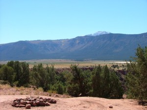
Onion Creek was mellow and the water crossings weren't very deep. We stopped at a wide spot to stand in the water and enjoy the scenery. The water was barely cool, almost room temperature. Summer came early to Moab. While we were there, a group went by with Fred in a long line of Jeeps. We'd spend more time with them by the time the day was over, but this time they passed us as we hung out at the water.

It was really nice on the trail, with perfect temperatures and big scenery. We had plans to do Onion Creek along with Rose Garden Hill and Top of the World, so we turned at the Rose Garden Hill trailhead when we got there.

We ran across Fred's group again as they were taking a break. They let us pass this time, so we got to the base of Rose Garden Hill before they did. They soon caught up and we were all parked at the bottom of the hill.

The hill has really changed since we were there last. It's very dug up, making the ledges much bigger. Someone from Fred's group went up the hill first and he had trouble finding a good line in many places. He made it up eventually, and we broke for lunch to watch the action.

About half of Fred's group went up the obstacle and we watched as none of them had an easy time doing it. We decided not to split up our group, so we changed our plans. Mike went up Rose Garden Hill, and then turned around and came back down it. He said it was tough, so we'd have to try it again when we have a different group. There's always more to do!

After lunch we headed back out the way we came and drove out to the granary near the Rose Garden Hill trailhead. We snapped a couple pictures but didn't get out. When we got back to Onion Creek we drove to the end to find Thompson Canyon instead, a new trail for the group. It all worked out just fine.

airing_down
along_a_ridge
big_sky
cinnamon_tire
climb
crazy_colors
curve
desert
enjoying_the_creek
eric_and_mike
eric_at_the_start
first_crossing
flower
green_and_red
interesting_features
julie_at_the_start
julie_wants_to_go_wheeling
layers
little_hills
little_water
long_stretch
matt_at_the_start
mellow_trail
mesa
mike_at_the_start
monica_at_the_start
monica_in_scenery
monica_on_the_trail
narrow_trail
near_the_end
next_to_the_creek
scraggley
standing_in_the_creek
start_of_the_trail
sunshine_climb
trail_ahead
up_and_over
valley_ahead
view_from_the_top
walt_at_the_start
wavy

Report from a Different Day

October 5, 2005

Led by Monica I.
We ran this trail as the first one of our Fall trip to Moab, and the weather was gorgeous. We were surrounded by reds and greens, with a nearly cloudless blue sky above us. We started out trying to not get muddy, but eventually we just gave up. There was…
Join Us!
If you aren’t a Member or Subscriber, you can’t see all of the content on this site. Get membership information to see why this site is best when you join and log in

Information for Subscribers

When you log in you’ll see more information here:

  • Recent Community Forum posts
  • Recent polls
  • Upcoming Events you can attend
  • Links to online users

© 2000-2022 · TrailDamage.com · Terms and Conditions · About · Contact
Trail information is only accurate on the date posted. Trails may have changed or closed since that date. Use this information for historical purposes only.
Contact the Forest Service or Bureau of Land Management for up-to-date trail information.

/* ----------------------------------------- */ /* View slug: reports-other-reports-for-same-trail-slider - start */ /* ----------------------------------------- */ /* place the prev/next controls on the sides */ .td-transition-controls .wpv-filter-next-link, .td-transition-controls .wpv-filter-previous-link { border: none; font-size: 300%; position: absolute; top: 70px; } .td-transition-controls .wpv-filter-previous-link { left: 0; } .td-transition-controls .wpv-filter-next-link { right: 0; } /* center the page selector horizonatally */ .td-transition-controls ul.wpv_pagination_dots { text-align: center; margin-top: 10px; } /* center the page selector horizonatally */ .td-transition-controls ul.wpv_pagination_dots li.wpv_pagination_dots_item, .td-transition-controls .wpv_pagination_dots li a { display: inline-block; float: none; } /* remove the default styles */ .td-transition-controls .wpv_pagination_dots li a { text-decoration: none; border-bottom: none; } .td-slider-container { padding: 0 25px; margin-bottom: 20px; position: relative; width:100%; display:table; } .td-slides { position: relative; } .td-slides-image { float:left; display:table-cell; } .td-slides-image img { border:1px solid #c0c0c0; } .td-slides-content { padding:4px 4px 4px 10px; border-top:1px solid #c0c0c0; border-right:1px solid #c0c0c0; border-bottom:1px solid #c0c0c0; display:table-cell; height:227px; overflow:hidden; } .td-slides-content h3 { margin-top:8px; } .td-slides-leader { font-size:smaller; margin-top:4px; } /* ----------------------------------------- */ /* View slug: reports-other-reports-for-same-trail-slider - end */ /* ----------------------------------------- */
/* ----------------------------------------- */ /* Content Template: Template for a Single Report - start */ /* ----------------------------------------- */ .entry-header { display:none; } .entry-content h1 { margin-top:16px; padding-top:0; } h1 a { color:#222; } h1 a:hover { color:#666; } p.entry-meta { font-size:small; } #report-body-spacer { clear:both; width:100%; height:20px; } #addtoany-bar { margin-bottom:2em; text-align:center; } .category-reports .post-info .author, .post-info .date { display: none; } .addthis_recommended_horizontal { text-align:center !important; } /* ----------------------------------------- */ /* Content Template: Template for a Single Report - end */ /* ----------------------------------------- */ /* ----------------------------------------- */ /* Content Template: Loop item in REPORTS Runners - start */ /* ----------------------------------------- */ #runners-container { width:100%; clear:both; } .runner { border:1px solid #c0c0c0; margin:0 6px 6px 0; float:left; width:49%; height:81px; } .runner-image { float: left; } .runner-image img { margin:2px 10px 0 2px; height:75px; width:75px; } .runner-name { text-transform:uppercase; } .runner-name a { color:#222; } .runner-name a:hover { color:#666; } .runner-vehicle { font-size:small; } @media only screen and (max-width: 768px) { .runner { width:100%; } } /* ----------------------------------------- */ /* Content Template: Loop item in REPORTS Runners - end */ /* ----------------------------------------- */